Monthly Archives: June 2017
Forecast for Friday, June 30, 2017
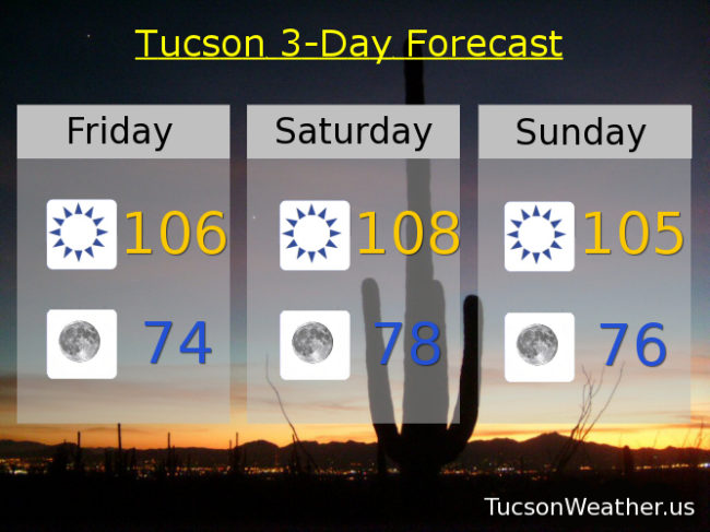
Refreshingly cool this morning! Dewpoint is in the teens and that has allowed us to cool off considerably. Low 70s right now at the airport with 66 on my deck thermometer! Dry air also warms quickly so it looks like our streak of days over 105 will continue today and keep going through Sunday. Moisture increasing for slight thunderstorm chances for the 4th and into next week. Stay tuned!
Sunny today with a high near 106.
Clear tonight with a low in the mid 70s.
Sunny tomorrow near 108ish. 105 Sunday. 103 Monday. Slight chance for storms Tuesday through Thursday with highs near 104, 105 and 107 respectively.
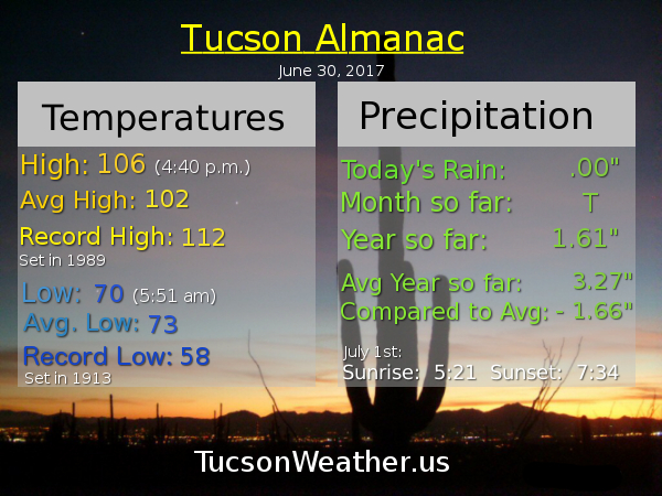
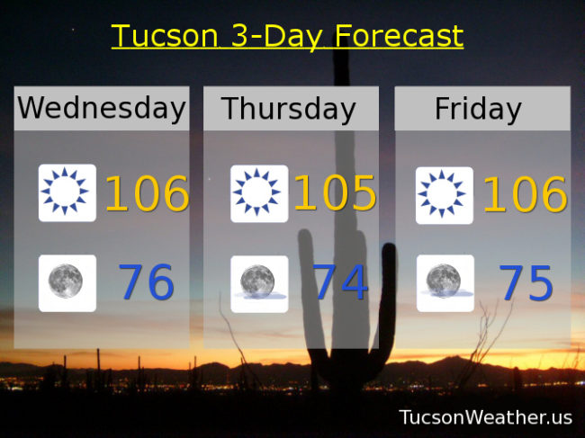
Almanac for Thursday, June 29, 2017
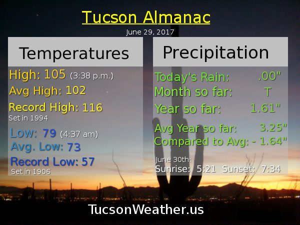
Forecast for Thursday, June 29, 2017
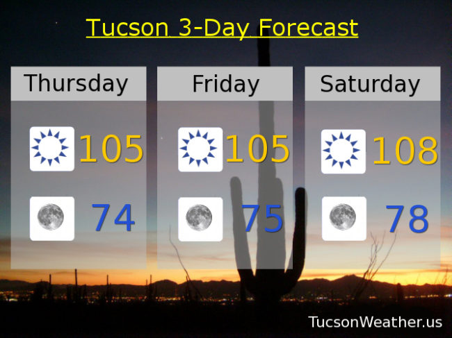
At least we broke the streak of record days in a row of lows at or above 80 degrees. 79 this morning is refreshingly “cool”! Hot and dry through the weekend. I found out yesterday that we are like number 5 all time for consecutive days over 105! That streak will continue for another 4 days if the forecast comes exactly true. I’ll hunt down the specifics, but all this record heat is making me feel good about my urban survival skillz! Moisture on the increase next week for a chance of storms especially south and east of Tucson.
Sunny today with a high near 105.
Clear tonight with a low in the mid 70s.
Sunny tomorrow 105ish. 108 Saturday. 105 Sunday. 104 Monday and for the 4th. Slight chance for storms Wednesday 104.
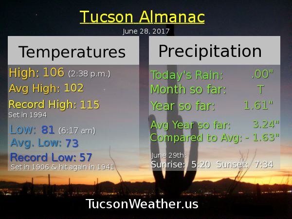
Almanac for Wednesday, June 28, 2017
Forecast for Wednesday, June 28, 2017
I feel like after last week’s heatwave 105-108 isn’t that bad. I’m still not hiking in the afternoon. Dry westerly flow for the next few days and then a moisture return possible starting early next week. Perhaps a few storms starting then. Stay tuned!
Sunny today with a high near 106.
Clear tonight with a low in the mid 70s.
Sunny tomorrow near 105ish. 106 Friday. 108 Saturday. 105 Sunday. Slight chance of storms Monday 104. Mostly sunny 4th of July 105.
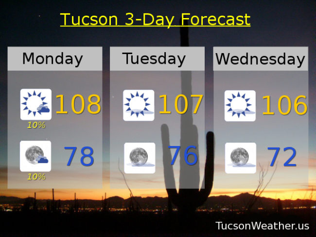
Almanac for Tuesday, June 27, 2017

Forecast for Tuesday, June 27, 2017

Yesterday morning we started the morning with a new record high minimum temperature for the date with a not so low low of 83. We followed that up with a high of 107. Somewhat similar temperatures today with a degree or three cooler to start the day and perhaps a degree warmer this afternoon. Drier air is moving in and high pressure moving south for slightly cooler weather this week, but it’s still hot. Moisture to start to increase from the south by the end of the weekend. Will it make it far enough north for storm chances in Tucson by the 4th? Maybe. We’ll all have to stay tuned!
Sunny today with a high near 108.
Mostly clear skies tonight with a low in the upper 70s.
106 tomorrow. 105 Thursday and Friday. 107 Saturday. 105 Sunday. Slight chance for a storm or two Monday 103.
Almanac for Monday, June 26, 2017

Forecast for Monday, June 26, 2017
Lingering moisture today for a few afternoon/evening storms possible. Hopefully near you!, but they will be few and far between. High pressure weakening and moving south opening the door for a drying and cooling trend this week. It’ll still be hot! Just not over 110 hot. Looks like a moisture surge will start Sunday/Monday just in time for the 4th of July. Viva Monsoon 2017!
Mostly sunny today with a slight chance of a storm and a high near 108.
Mostly clear tonight with a slight chance of a storm before midnight and a low near 78.
Sunny Tuesday 107ish. 106 Wednesday. 104 Thursday. 105 Friday. 106 Saturday. Isolated storms Sunday 105.