Monthly Archives: July 2017

Forecast for Wednesday, July 26, 2017

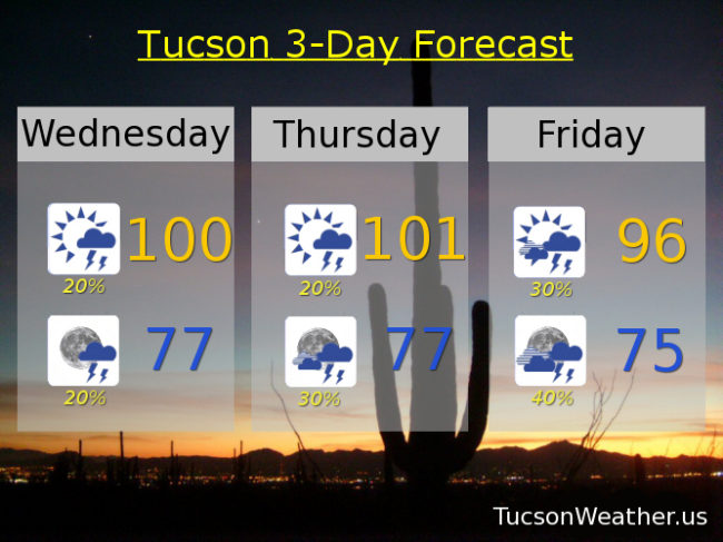
No rain across the area yesterday.  It’s been awhile since we could say that!  The good news is Monsoon 2017 is cutting its vacation short!  Moisture on the increase today and storm chances will be ramping up as we approach the weekend.  Friday afternoon into overnight Friday night/Saturday morning looks particularly interesting.  If the forecast comes true today’s high of 100 will be the first time we’ve hit 100 since July 15th!  There will be a few storms around this afternoon/evening as well.  Hopefully near you.  Viva Monsoon 2017!

Mostly sunny today with a chance for afternoon storms and a high near 100.

Partly cloudy tonight with a chance for a few storms before midnight and a low in the upper 70s.

Mostly sunny tomorrow with a chance for afternoon and evening storms with a high near 101.  Scattered storms Friday, Saturday and Sunday with highs in the mid 90s.  A chance for storms Monday and Tuesday with highs in the upper 90s to near 100.

Forecast for Tuesday, July 25, 2017

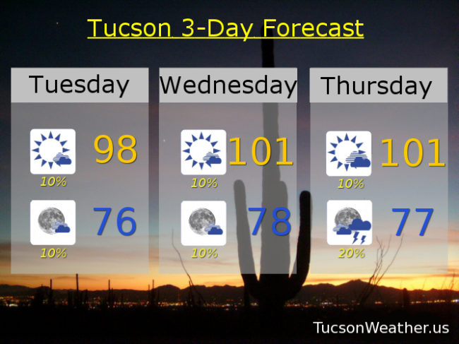
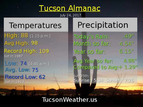
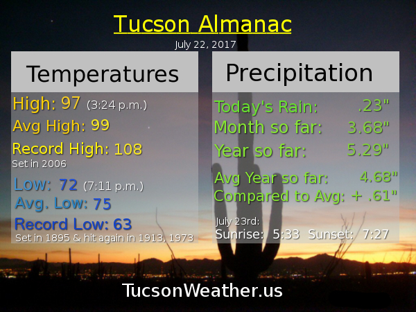
Yesterday was the first July day not to hit 90 degrees since 2010!  A high of 88 and a half inch of rain at the airport.  Just lovely 🙂  Monsoon 2017 will be taking a much deserved break for a few days with drier air and higher highs today through Thursday.  Our Monsoon high then moves to northern Arizona giving us a SE flow and right back to more moisture and more storms.  Best Monsoon Evah!

Mostly sunny today with a slight chance of a storm or two, hopefully near you, and a high in the upper 90s.

Mostly clear tonight with a slight chance of a storm before midnight and a low in the mid 70s.

Slight chance of a storm or two Wednesday and Thursday with highs near 101.  Scattered afternoon and evening storms Friday through Monday with highs in the mid to upper 90s.  Enjoy!

Forecast for Monday, July 24, 2017

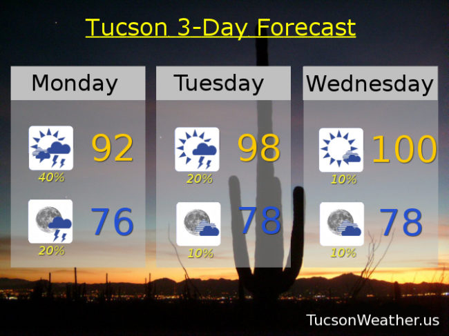
What a Monsoon!  The airport picked up another third of an inch yesterday.  We are now officially over 4 inches so far this month!  The average for the entire Monsoon is just over 6 inches so we are well on our way.  Our disturbance in the force is north of us today so best chances of rain will be to our north, but we still have plenty of moisture around for scattered storms this afternoon.  More of a southerly flow today so storms that do form will be moving to the north so the threat of heavy rain is somewhat diminished.  We start to dry out and subsequently warm up tomorrow into Thursday but still a storm or two, hopefully near you.  Moisture surges again Friday into the weekend with an uptick in storms expected.  Viva Monsoon 2017!

Partly sunny today with scattered afternoon and evening storms and a high in the low 90s.

Becoming partly cloudy tonight with a few storms before midnight and a low in the mid 70s.

Mostly sunny with isolated storms Tuesday, Wednesday and Thursday with highs near 98, 100 and 99 respectively.  Scattered storms possible Friday, Saturday and Sunday with highs near 97, 95 and 96.

Forecast for Sunday, July 23, 2017

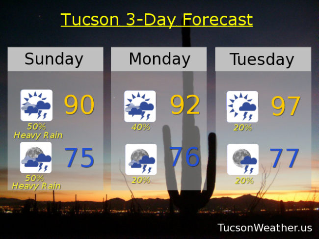
Get ready for an interesting 24-36 hours.  Looks like an upper level low will be moving across the area today into tomorrow morning.  That should lead to pretty widespread heavy rainfall.  Worst case scenario we will have widespread flooding to go with it.  Confidence is pretty high that there will be some flooding rain in the area.  As a result of the clouds and rain potential we could see a high only in the upper 80s to near 90.  If we stay below 90 for a high today it will be the first July day below 90 since 2010.  Let’s make it happen!  Drying out quite a bit by Tuesday with less storm activity and warmer temperatures into next weekend.  Looks like the wetter weather returns next week!  Best Monsoon Evah!

Mostly cloudy today with showers and storms likely, some with heavy rain, and a high near 90.

Mostly cloudy tonight with showers and storms likely, some with heavy rain, and a low in the mid 70s.

Partly sunny tomorrow with scattered showers and storms and a high in the low 90s.

Partly cloudy Tuesday through Saturday with isolated storms and highs in the upper 90s.

Forecast for Saturday, July 22, 2017

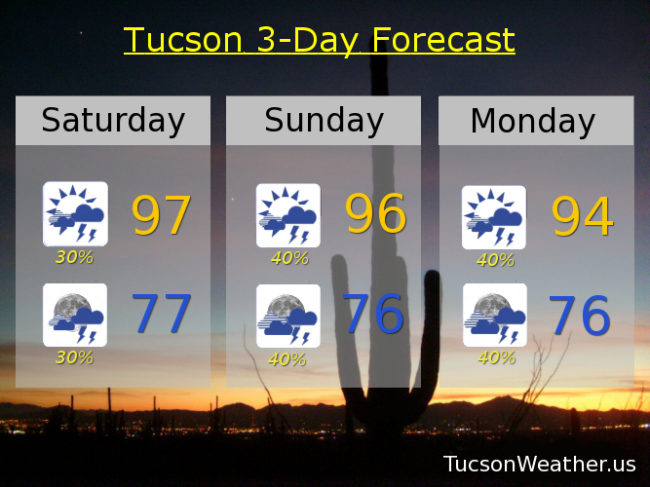
Heavy rain the biggest threat from storms today as storms that form won’t be in a hurry to go anywhere.  Chance of storms goes up tomorrow as an upper level low moves through from the SE.  The inverted trough as it’s called will be giving us numerous storms in the forecast Sunday and Monday.  Then we dry out a bit, but still keep widely scattered showers and storms in the forecast.  Viva Monsoon 2017!

Scattered afternoon and evening storms today with a high in the upper 90s.

Scattered showers and storms tonight with a low in the upper 70s.

Scattered to numerous showers and storms Sunday and Monday with highs in the mid 90s.

A 20% chance for afternoon and evening storms Tuesday through Friday with highs in the mid to upper 90s.