Monthly Archives: December 2017

Forecast for Sunday, December 31, 2017

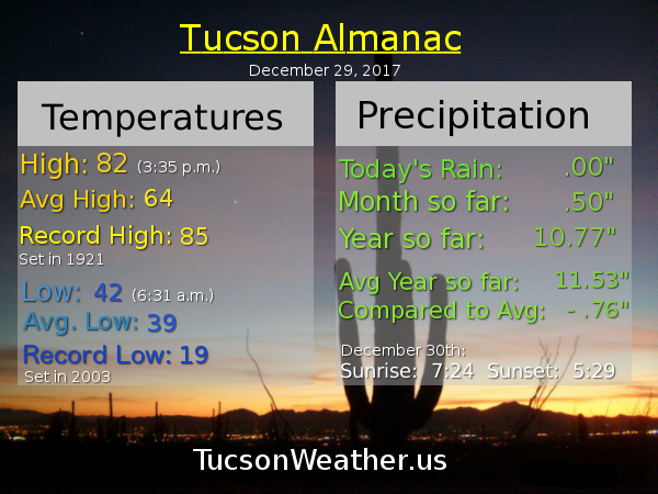
Last day of the hottest year ever recorded in Tucson’s 123 years of record keeping. The 4.5 billion years before that? Who knows! Anyway. We are the envy of a frozen nation once again with high pressure keeping our highs high and our lows not so low. A disturbance in the force undercutting the high is expected to bring us increasing high cloudiness for possible sunrise and sunset enhancement. Still looking past the 7 day forecast for a possible change in the weather pattern. That could be good for a rain starved desert. You know. If it happens. Stay tuned!

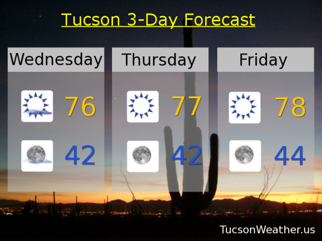
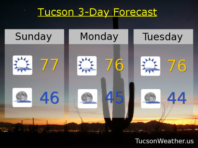
Increasing clouds today with a high in the upper 70s.

Mostly cloudy tonight with a low in the mid 40s.

Mostly sunny tomorrow with a high in the mid 70s. Mid 70s Tuesday, Wednesday, Thursday and Friday. Low 70s Saturday.

Forecast for Saturday, December 30, 2017

All righty then. 82 yesterday! 82ish expected today. The difference is yesterday’s record high is 85 set in 1921. Today’s record is 81 set in 1917. Looks like that is gonna fall by the wayside. The wayside. Where stuff falls, I guess. Anyway. It’s warm. Good day to play frisbee and other fun outdoor activities. “Cooling” off a bit as 2018 approacheth. Mid 70s by New Year’s Day. Mid 70s Tuesday, Wednesday, Thursday and Friday too. The models think that maybe the pattern will change by the end of next week or weekend. Storm(s) headed our way? Stay tuned!

Forecast for Friday, December 29, 2017

80?! Why not. High pressure doin’ it’s thing and we are Under the Doom. 80 yesterday was wonderful if you are into that sort of thing for late December. Even got close to the record of 82! Today we should venture into the low 80s, but the record of 85 should stay safe. 80ish tomorrow and upper 70s Sunday. A storm off the California coast approaceth next week but it looks like just more clouds and cooler temperatures. Even then still above average to start 2018. Mostly sunny New Year’s Day and Tuesday low 70s. Mid 70s Wednesday and Thursday. Party like it’s 2018!

Forecast for Thursday, December 28, 2017

I mean, we could hit 80. Why not?! Just don’t show this to your friends and family in the rest of the country. Right now in Spokane it is 19 with freezing fog. Chicago it is 5 degrees with snow in the forecast. It’s sunny and 13 in New York City. 17 in Memphis right now with a high near freezing expected. 38 in Dallas right now with a wintry mix possible Sunday. 8 currently in Indianapolis with a forecast high near 19 and snow showers tonight. So, why not 80?! Cooling off a little to start the new year, but we will stay high and dry until further notice. Enjoy!

Sunny today upper 70s. Near 80ish tomorrow and Saturday. Upper 70s Sunday. Mid 70s New Year’s Day. Low 70s Tuesday and Wednesday. Lows in the mid to low 40s.

Forecast for Wednesday, December 27, 2017

High clouds overnight acting like a blanket to keep some of the heat from escaping into space (echo: space space space) therefore our low temperatures are warmer this morning. Look for the high clouds to stick around today, but start thinning by this afternoon. Still a chance for sunrise and sunset enhancement! Meanwhile our highs will stay high for this time of year. Mid 70s today. Upper 70s tomorrow, Friday and Saturday. The big question by Sunday into next week (year) is the low currently south of Baja California. Will it bring us moisture for a slight chance of showers? Right now the answer is no for Tucson and probably no for international border areas. Stay tuned! Sunday’s high mid 70s. Low 70s New Year’s Day. Upper 60s Tuesday.