Monthly Archives: February 2018

Forecast for Wednesday, February 28, 2018

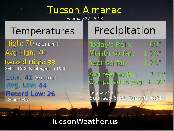
Showers winding down in the Metro as I write this at 5:46 in the a.m. Still snowing in the surrounding mountains and as low as Oracle. Sorry Vail and Saddlebrooke, looks like you missed out on the snow showers although I suppose it could still happen briefly in the next hour or two. The airport picked up .17″ so far and that will likely be the total for this last day of February. That brings us to 1.93″ for the month and 1.95″ for the year. That’s .16″ above average for the year to date. We’ll take it! Thank you February for reversing our Winter precipitation fortunes.

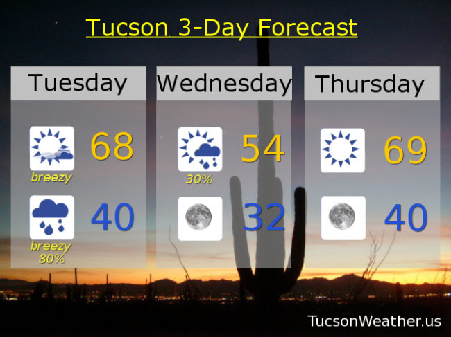
The storm exits stage east today with clearing skies and a high near 55ish. Dry enough by tonight with clear skies that tomorrow morning’s low will be near freezing. You may want to consider letting the teenagers crash inside tonight. Maybe.

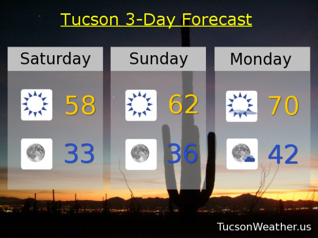
Warming up with sunshine tomorrow as March comes in like a lamb. High in the upper 60s to near 70, just a degree or two below average for this time of year.

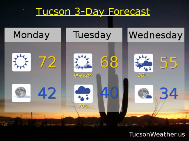
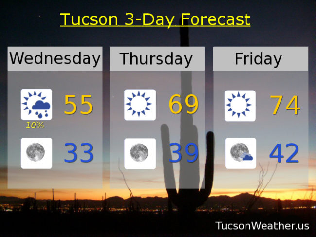
Sunny and warmer Friday mid 70s. Low 70s Saturday. Mid 60s Sunday. Near 70 Monday. Mid 70s Tuesday. Enjoy!

Forecast for Tuesday, February 27, 2018

If you have hatches you might want to batten them down. A Winter Storm is barreling our way with gusty winds today and tonight and rain and low mountain snow tonight into tomorrow morning. The storm has slowed slightly which is good news for rain and snowfall amounts. Those expected values have been bumped up slightly. The other big news is the snow level. How low will it go before the storm moves on Wednesday? The National Weather Service has issued a WINTER WEATHER ADVISORY above 4,500 feet starting at 11:00 tonight until 11:00 tomorrow morning, so be advised, there will be Winter weather. Up to 3 inches of snow possible between 4,500 – 6,000 feet and 4 to 8 inches above 7,000 feet. Rain in valley locations expected between .15″ – .30″ ish for most of us. The snow level is expected to go as low as 3,500 feet Wednesday morning, so it’s completely possible that Catalina and Corona de Tucson could see some snow falling, but not expecting any accumulations. Saddlebrooke and Vail maybe?! After the storm blows through tonight and tomorrow we’ll see a warm up Thursday through Saturday and then a little cooler Sunday and Monday.

Mostly sunny today with increasing clouds. Windy with SSW winds 15-25 mph gusting over 35 by this afternoon and a high near 68ish

Breezy tonight with rain and mountain snow likely. West winds 15-25 mph relaxing after midnight and a low near 40.

Scattered showers tomorrow morning becoming mostly sunny and a high near 54.

Near freezing Thursday morning with sunshine and an afternoon high near 69. Mid 70s Friday. Low 70s Saturday. Mid 60s Sunday. Upper 60s Monday.

Forecast for Monday, February 26, 2018

Winter in Arizona! It’s been shorter than even our normal, but it is here for less than one more week. More accurately, it is here for one more storm! Will there be others in March? Too far out to tell right now, but we do have a good handle on Tuesday night/Wednesday.

Sunny today with a high near 72ish.

Mostly clear tonight with a low near 42.

Breezy tomorrow as our storm approacheth with winds becoming SSW in the afternoon 15-25 mph gusting to near 35 (OK, that’s windy) and a high in the upper 60s.

Rain likely tomorrow night with snow levels starting around 6,000 feet falling as low as 3,000 feet by morning! Valley locations should see between .1″ and .5″ of rain with 2 to 6 inches of snow above 5,000 feet. Low in the metro near 40.

Scattered showers Wednesday, mainly in the morning, with a high in the mid 50s.

Sunny Thursday near 70. Mid 70s Friday. Low 70s Saturday. Upper 60s Sunday. Enjoy!

Forecast for Sunday, February 25, 2018

Our Tuesday night/Wednesday storm is coming into focus as we get closer. Looks like a tenth to a quarter inch of rain for valley locations around the metro with two to five inces of snow in the mountains. Snow levels starting out around 6,500 feet crashing to 3,500 feet by Wednesday morning.

Right now we are between systems and that means sunshine and warming temperatures. A few degrees warmer than yesterday today with a high in the low 60s. Low tonight in the mid 30s. A degree or two above average for this time of year tomorrow with a high in the low 70s.

Breezy with increasing clouds Tuesday as the storm approacheth with a high in the mid 60s. Showers likely Tuesday night with a low near 40. Scattered showers mainly in the morning Wednesday with a high in the mid 50s.

Sunny and warming up Thursday with a high in the upper 60s. Low 70s Friday and Saturday. Enjoy!

Forecast for Saturday, February 24, 2018

Some frost out there this morning with a low of 35 so far. Yesterday’s high was a good 6 degrees below the average of 70 for this time of year and today will be cooler. It may not feel as cold since the wind will be lighter. In any event, our active weather pattern is remaining rather active with another weak system missing us to the north today. We’ll stay sunny but cool with a high in the upper 50s.

Clear skies tonight with a low near freezing to start your Sunday. Tomorrow’s high recovering to the low 60s.

Sunny Monday near 70!

A storm approacheth Tuesday with a slight chance for showers and breezy with a high in the mid 60s. Best chance for rain and mountain snow will be Tuesday night into Wednesday with a low near 40 and a high in the upper 50s.

Back to sunshine Thursday with a high in the upper 60s. Low 70s Friday.