Tag Archives: Excessive Heat Warning

Forecast for Wednesday, April 29, 2020

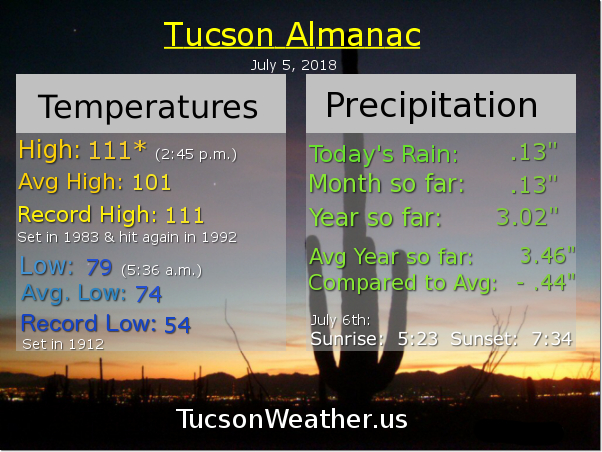
Mike Mike Mike Mike Mike. What day is it Mike? Another record high tying day. That’s what day it is!

The year was 1992. The high was 102. It was the hottest it had ever been on an April 29th. That is. Until 2020. It’s the return of 102. This time it’s personal. (not in theaters anywhere)

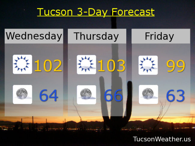
Yep. If the forecast comes exactly true we will tie the record high. Today should be the first 100 of the year which will be the 5th earliest first 100 in Tucson’s history. Additionally, tomorrow’s forecast has dropped a degree, but 103 will break the record of 102. That will fall short of the all time high for April of 104 which is still within reach. (I’m not sayin’ I’m just sayin’) An EXCESSIVE HEAT WARNING is still in effect for tomorrow so be warned, the heat will be excessive. Sounds like fun! Stay tuned to Tucson Weather for all the drama.

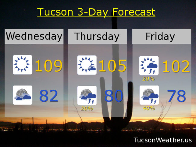
Sunny today 102. Mid 60s tonight. 103 tomorrow. Breezy and 99 (i’ve been waiting so long) Friday. Mid 90s Saturday. Upper 90s Sunday, Monday, and Tuesday. Enjoy!

Forecast for Tuesday, April 28, 2020

Nice! Only 96 today. Sure, that’s 10 degrees above average for this time of year, but it is 1 degree cooler than yesterday (so there’s that) and much better than the insanity ahead. Low 60s to start the day tomorrow. Tomorrows high near 101 which is 1 short of the record. Thursday will set a new record for April 30th and if 104 comes true then it will tie the hottest day ever recorded in April in Tucson’s recorded history. (I guess no one had pens or thermometers before 1896?) No wonder the National Weather Service has issued an EXCESSIVE HEAT WARNING for Thursday. Be warned. The heat will be excessive. Cooling off to near 100ish on Friday. Upper 90s Saturday. Mid 90s Sunday and Monday. Enjoy!

Forecast for Tuesday, August 7, 2018

I had a weird dream that my cell phone woke me up with an EXCESSIVE HEAT WARNING warning at 3:00 a.m. Then I woke up and saw that it wasn’t a nightmare, it was true! Be warned. There will be excessive heat. Yesterday we tied the record high of 109. A couple of stray storms made it’s way across town last night, hopefully near you! The airport picked up .05″ which beats a swift kick (don’t ask me how I know that). Moisture is increasing across the area, so today’s expected high of 106 will be a bit uncomfortable. The good news is storms should fire earlier today and by this evening more of us will have a chance of getting wet. Tonight’s low in the upper 70s.

High pressure moving northward with an inverted trough riding our way from the east. Lots of moisture including a couple of hurricanes south of Baja California that will help push more our way. It all adds up to what should be an active week for Monsoon 2018! Early indications are that prime time will be tomorrow night and storm chances remain good into the weekend!

Partly sunny tomorrow with a 30% chance for storms and a high near 99ish. Mostly cloudy tomorrow night with a 50% chance for storms mid 70s. 30%/40% Thursday low 90s. 20%/40% Friday mid 90s. 30%/40% Saturday mid 90s, 20%/30% Sunday mid 90s. 20% Monday mid 90s.

Forecast for Monday, August 6, 2018

Must survive. One. More. Day. 107 yesterday meaning the record of 108 remains. Not quite excessive heat since that threshold is 108 in these parts. Still. 109 today, if it comes true, will tie the record set in 1995. I’m thinking we’ll be just shy, but still, an EXCESSIVE HEAT WARNING remains until 8:00 tonight.

The really good news is Monsoon 2018 is fixin’ to return to us! High pressure moving off to the north opening the door for more moisture by tomorrow afternoon. A couple of tropical systems south of Baja California will push a Gulf of California surge of moisture into southern Arizona. Add an inverted trough and storms should be firing starting tomorrow evening with daily activity expected through the weekend! Viva Monsoon 2018!

20% chance for storms tonight with a low near 80.

10% chance tomorrow near 104ish. 30% tomorrow night upper 70s. 20%/40% Wednesday 98. 20%/40% Thursday 96. 30%/50% Friday 95. 30%/40% Saturday 94. 20% Sunday 95.

Forecast for Sunday, August 5, 2018

Run to the hills! You know. Because it’s cooler up there. They don’t call it Summerhaven for nothin’! High pressure is large and in charge and bringin’ the heat. EXCESSIVE HEAT WARNING from 10:00 this morning until tomorrow night at 8:00. Be warned, the heat will be excessive. Please make sure you stay hydrated lest you burst into flames. Never leave living things unattended in the car (oven) and walking the dog on hot asphalt is just cruel.

Today’s expected high of 108 would tie the record last set in 2009. Enough moisture around for a chance of an isolated storm this evening! Hopefully one near you, but it’s just a slight chance with a low tomorrow morning near 80.

Tomorrow’s record high is 109. We’ll be close! with an expected high of 108. Again, enough moisture trapped under the high for a 20% chance of storms tomorrow evening and a low in the upper 70s.

Our fortunes begin to reverse themselves as the high moves to the north. A tropical system near Baja California may even get into the act! Slight chance for a storm Tuesday afternoon with a high near 105. 20% chance Tuesday night upper 80s. Slight chance for a storm Wednesday 102. Wednesday night looks very promising with a 40% chance for storms mid 70s. 10%/30% Thursday 99ish. 20%/50% Friday 98. 30% Saturday mid 90s. Be cool!

Forecast for Wednesday, July 25, 2018

Congratulations! You survived the record heat yesterday. 112 was just two degrees from the all-time July record of 114. Yikes! The good news is the dewpoint fell into the low 40s yesterday so 112 felt like 112 with a relative humidity of just 9%. One more day of excessive heat with the EXCESSIVE HEAT WARNING expiring at 8:00 tonight. 109 this afternoon would tie the record if it comes exactly true. Be cool!

Still kinda hot the next couple of days with 105ish tomorrow and 102 Friday. As the high pressure moves to the NW moisture will be increasing and so will the chance for storms. 20% chance for storms as early as tomorrow night. 20% Friday and 40% Friday night!

Scattered storms continue this weekend into next week as temperatures fall to near our average of 98 for this time of year. 20% Saturday and 30% Saturday night 98. 20% Sunday and 30% Sunday night 97. 20% Monday and 40% Monday night near 100. 30% Tuesday 100.

Forecast for Tuesday, July 24, 2018

EXCESSIVE HEAT WARNING continues until tomorrow night at 8:00, so be warned, the heat will be excessive. A couple storms popping up this morning near Catalina to near Oracle. Nice light show from the deck from about 3:30 until after 4:00. Another isolated storm right now (6:10 a.m.) over the Rincons. We’ll keep isolated storms in the forecast today, but the weather headline is the head. High pressure over SE Arizona basically trying to kill us. Today’s forecast high of 111 will break the daily record of 109 and is just 3 degrees shy of the all-time record high for July. Let’s hope it doesn’t come to that! Tonight any stray storms that form will dissolve leaving partly cloudy skies and a not so low low in the low 80s.

109 tomorrow will tie the record high if it comes exactly true.

High pressure moving to the NW will open the door for a return of deeper moisture. That means a better chance for storms starting Thursday evening and increasing this weekend. Thursday’s high 104ish. 20% chance for storms Friday 101. 30% Saturday 98. 20% Sunday upper 90s. 30% Monday upper 90s. Be cool!

Forecast for Monday, July 23, 2018

Pretty nice on the deck this morning with an amazing sunrise! Don’t fall for it. It’s a trap! EXCESSIVE HEAT WARNING in effect starting at 10:00 this morning and lasting until Wednesday at 8:00 p.m. Be warned, the heat will be excessive! 109 is today’s record high and we are expected to be right there. Tomorrow’s record of 109 is gonna fall with an expected high of a scorching 112! Wednesday’s record high, also 109, is also expected to fall with an expected high of 110ish. A bit drier than last week with dewpoints in the mid 50s, but still enough moisture for a very slight chance for a storm in the evenings the next few days.

Then our fortunes start to turn as Monsoon 2018 roars back into SE Arizona! A moisture surge from the south overnight Wednesday into Thursday morning will give us a better chance for storms. The flow becomes SEasterly by the weekend with an even better chance for storms, even in the overnight hours. Hang in there! This heat too shall pass.

Sunny today 109. 112 tomorrow. 110 Wednesday. 10% Thursday 104. 20% Friday 99. 30% Saturday 98. 40% Sunday upper 90s.

Forecast for Thursday, July 5, 2018

So you’re saying there’s a chance! Before we dive in to a busy forecast let’s start with yesterday. 103 for the third day in a row with a bit of an afternoon breeze. Those temperatures and wind speeds are on the way up along with storm chances. EXCESSIVE HEAT WARNING today from 10:00 a.m. until 9:00 p.m. so be warned, the heat will be excessive. Make sure you stay hydrated lest you burst into flames! Today’s expected of high of 108 is getting too close for comfort to the record of 111. Also. A slight chance for an isolated storm or two this afternoon and evening. It’s still too dry at the surface so IF we see a storm it’s likely to create some strong gusty winds and maybe mostly dry lightning.

Any storms that form will die with the setting sun and the east winds will start to increase overnight keeping our morning low not so low in the low 80s. East winds could gust to 40 mph and so we have a WIND ADVISORY from 3:00 a.m. until 3:00 p.m.. Be advised, it’s gonna be windy.

Mostly sunny and windy tomorrow like I just mentioned with a high near 104ish.

Moisture on the increase this weekend into next week. Storm chances on the rise! Singing in the rain and dancing in the streets! 10% chance for storms Saturday 105. 30% chance for storms Saturday night! 20% chance for storms Sunday 102 and 40% Sunday night. 40% chance for storms Monday 100. 40% chance for storms Tuesday upper 90s. 40% chance for storms Wednesday mid 90s.