Tag Archives: Excessive Heat Watch

Forecast for Monday, June 1, 2020

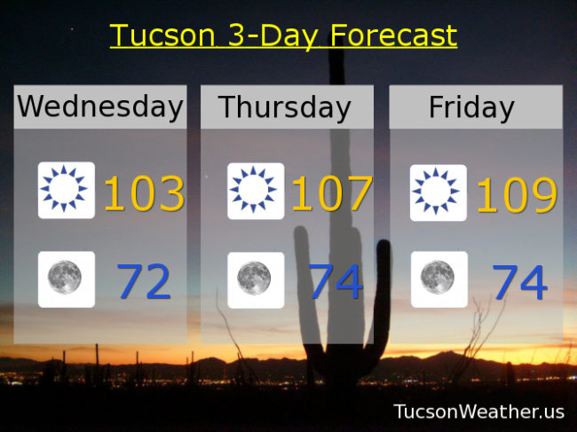
Welcome to June! The start of Summer, meteorologically speaking. The weather has been more like late June lately. Normally when Monsoon starts to clear its throat we’ll have thunderstorms form that rain into dry air and provide gusty winds near showers with a few getting a nice brief soaking. One more day of early type “Monsoon” action. Then it’s back to early June weather and an EXCESSIVE HEAT WATCH later this week. Watch out! The heat will be excessive (again)! Here’s what I’m talkin’ about…

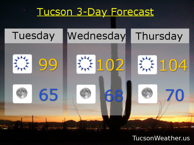
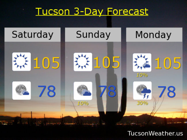
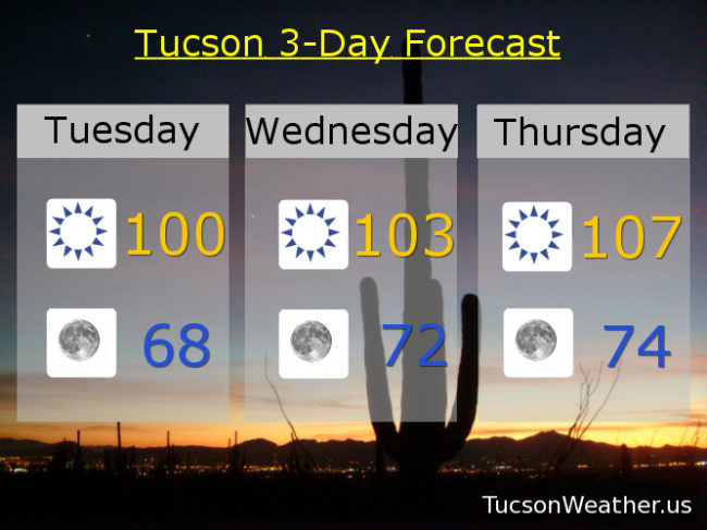
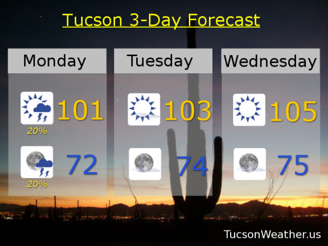
Mostly sunny today with isolated showers possible and a high of 101. Isolated showers this evening becoming mostly clear low 70s. Mostly sunny tomorrow 103. EXCESSIVE HEAT WATCH Wednesday and Thursday with highs of 105 & 107 respectively. Mostly sunny 103 Friday. Upper 90s Saturday. 101 Sunday. Be Cool

Forecast for Tuesday, May 26, 2020

Heat so excessive the National Weather Service has expanded the EXCESSIVE HEAT WATCH from Thursday now through Saturday. Watch out! The heat will be rather excessive. Comfortable in the morning though. One of the benefits of a dry heat.

99 (I’ve been waiting so long) this afternoon with nuttin’ but Sun. Mid 60s tomorrow morning. 102 para tu manana. 104 Thursday. 106 Friday. 105 Saturday. 104 Sunday. 101 Monday. Be Cool!

Forecast for Saturday, August 4, 2018

I can’t even. I have no words. Monsoon 2018 what are you thinking? EXCESSIVE HEAT WATCH for Sunday starting at 10:00 a.m. until Monday night at 8:00? Really? Really. High pressure moving over our head suppressing storm chances and bringing the heat. But I thought Excessive Heat was defined in our area with temperatures of 108 and above? The forecast for Sunday and Monday “only” calls for 105. Yeah, well, moisture trapped under the high will make it feel like 108ish. So much for a dry heat! At least storm chances return to the forecast Monday night  with isolated storms back in the forecast the rest of the week as the high retreats northward. We will rebuild!

Mostly sunny today with a high near 105. Partly cloudy tonight upper 70s.

Hot and humid tomorrow with a high near 105 feeling hotter. 10% chance for a storm tomorrow evening low in the upper 70s.

10%/30% Monday 105 with a 108ish feels. 10%/20% Tuesday 103. 10%/20% Wednesday 101. 10%/20% Thursday 100. 20% Friday 98.

Forecast for Wednesday, June 20, 2018

Roses are red
Violets are not
It’s June in Tucson
It’s gonna be hot

Everybody into the pool
One great way to be cool
Or go to the movies
and see The Incredibles 2

Tomorrow, the first day of Summer
Astronomically speaking
3:07 a.m.
The Sun’s northern trek peaking

Summer in Tucson
This life we chose
Monsoon rains will get here when they do
That’s just how it goes

Sunny today 103. 107 tomorrow. 109 Friday with an EXCESSIVE HEAT WATCH. 103 Saturday. 100 Sunday. 101 Monday. 104 Tuesday.


Forecast for Tuesday, June 19, 2018

Bud, you were the best! But now you’re gone. Thank you for the rain and greening up the place a bit! We miss you. Now it’s just gonna get hot. So hot that the National Weather service has issued an EXCESSIVE HEAT WATCH for Friday, so watch for excessive heat. High pressure building in is the culprit. Still, a forecast high of 109 on Friday is still shy of the record of 114 set in 1988. It does get hot this time of year, but the morning’s are amazing for coffee on the deck. High pressure loosens it’s grip by the weekend for “cooler” temperatures. No rain in sight… yet. Stay tuned!

Sunny today with a high near 100.

Clear skies tonight with a low in the upper 60s.

103ish tomorrow. 107 Thursday. 109 Friday. 104 Saturday. 100 Sunday. 102 Monday.

Forecast for Tuesday, June 13, 2017

Refreshingly cool on the deck this morning with 65 degrees on both my thermometer and officially at the Tucson International Airport.  Very nice with my first cup of coffee and first light of day!  One more “cool” day and morning before we all scurry in to our AC to avoid the scorching Sun.  Our average high for this time of year is 100 and yesterday’s 96 and today’s expected 98 is pretty nice considering.  High pressure building in will have us melting or bursting into flames if we don’t stay hydrated and take other safety precautions.  We all remember the hikers that died in the heat last year, so even though I like to have some fun with stuff, please take it seriously enough to live!  An EXCESSIVE HEAT WATCH is in effect Saturday, Sunday and Monday so watch for excessive heat.  We could be in the 1-teens, so yeah, excessive.  Enough moisture next week for a few storms?  We’ll keep an eye on it and keep you posted.

Sunny today with a high in the upper 90s.

Clear skies tonight with a low in the mid 60s.

Sunny tomorrow near 104ish.  107 Thursday.  108 Friday.  109 Saturday.  111 Father’s Day.  114 Monday.

Forecast for Monday, June 12, 2017

Cooler weather is upon us!  Amazing mornings and not too hot in the afternoon today and tomorrow, but don’t get used to it.  Real deal heat is headed our way by the end of this week and the National Weather Service has issued an EXCESSIVE HEAT WATCH for Friday into Monday!  Basically you have until then to get your affairs in order and hoard as much water as you can.  Temperatures approaching or exceeding 110 by this weekend.  Stay tuned!

Sunny and bit breezy this afternoon with NW breezes 5-15 mph and gusty with a high in the mid 90s.

Clear skies tonight with a low in the mid 60s.

Sunny tomorrow with a high in the upper 90s.  Near 104ish Wednesday.  107 Thursday.  108 Friday.  109 Saturday.  110 Sunday.