Tag Archives: Red Flag Warning

Forecast for Monday, June 29, 2020

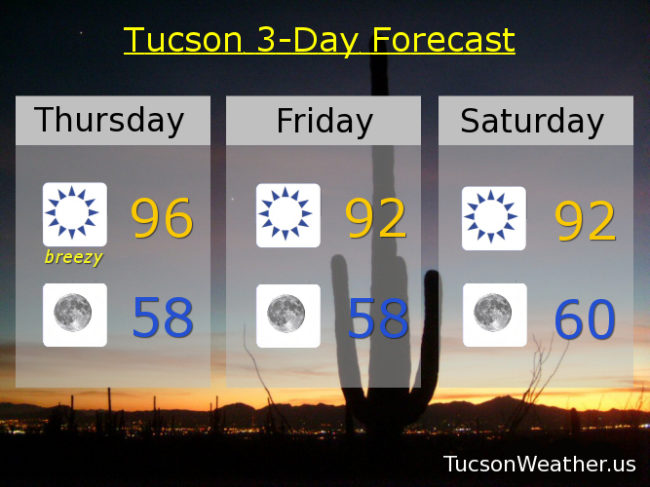
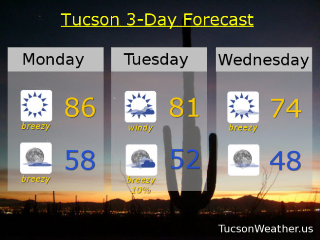
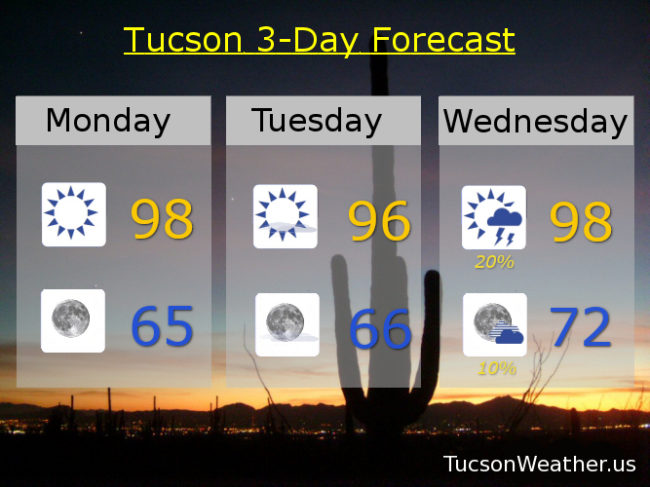
Another blustery day in the thousand acre desert… A RED FLAG WARNING AND a WIND ADVISORY (so be advised… it’s gonna be windy) have been issued for today. Perhaps a bit repeatedly redundant, but it gets the idea across. Gusty winds and a high fire danger. If you smoke, keep your butt(s) in your car! Increasing moisture and a chance for storms Wednesday and a better chance Thursday. It’s getting to be that time of year! Kinda hot for the 4th… and the 5th.

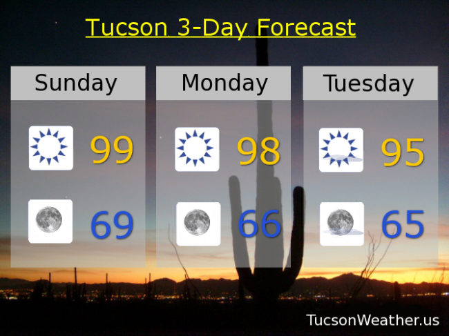
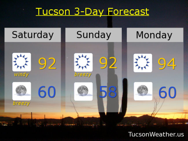
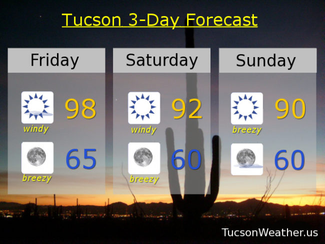
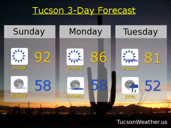
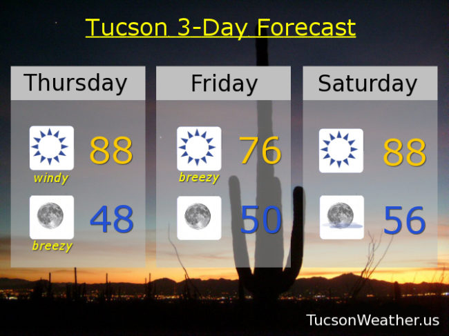
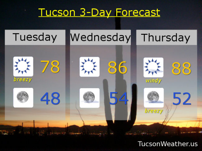
Sunny and windy today with SW winds 20-30 mph gusting to 40 and a high in the upper 80s. Winds relax tonight especially after midnight mid 60s. Still breezy fo sheezy tomorrow with WSW winds 15-20 mph gusting to 30 with a high “only” in the mid 90s. A 20% chance for afternoon and evening storms Wednesday (hopefully near you) upper 90s. A 30% chance Thursday upper 90s. Mostly sunny Friday 101. 10% chance for storms on the 4th 104. 10% Sunday 105. Enjoy!

Forecast for Sunday, June 28, 2020

Another good news bad news kinda day. First the bad news.. A RED FLAG WARNING has been hoisted for today and tomorrow. Windy, warm, and dry equals a high fire danger. Seriously 2020. Just stop. There is good news… Cooler! Highs below 100 and lows in the upper then mid 60s! Overspray that VO5 and enjoy the rest of the weekend!

Sunny and windy today with a high of 99 (I’ve been waiting so long) SW winds 20-30 mph gusting to near 40. Winds relaxing after midnight tonight with a low in the upper 60s. Sunny and windy tomorrow upper 90s. SW winds 20-30 mph gusting over 40. Breezy fo Sneezy Tuesday with SW winds 10-20 mph gusting over 25 and a high in the mid 90s. Sunny Wednesday (but not Windsday) upper 90s. A slight chance for a storm maybe Thursday upper 90s. Sunny Friday 102 para tu. Mostly sunny for the 4th 105. Hang in there!

Forecast for Thursday, May 17, 2018

Shocker! A RED FLAG WARNING is in effect from 11:00 this morning until 7:00 tonight. The winds won’t be all that bad. WSW 10-20 mph and gusty, but it’s just so stinkin’ dry one cigarette butt out of the car and the whole place could go up. Remember. The world is not your ash tray. (of course you already knew that, it’s just me being PC) Meanwhile, temperatures will moderate somewhat. Down a couple of degrees today and right at seasonal norms tomorrow and Saturday. More wind early next week with an increase of moisture well to our east. I only mention it because it’s a good sign of things eventually to come! Eventually. Until then, take it breezy!

Sunny and breezy today with a high of 96ish.

Clear skies tonight with a low in the upper 50s. (nice!)

Sunny and a bit breezy tomorrow with WNW winds 5-15 mph and gusty and a high in the low 90s.

Sunny Saturday low 90s. Mid 90s Sunday. Breezy Monday and Tuesday mid 90s. Mid 90s Wednesday.

Forecast for Sunday, May 13, 2018

Today’s Mother’s Day Special is sunshine and not as windy today, but still kinda windy. WSW winds this afternoon 15-25 mph gusting over 30. The last RED FLAG WARNING for awhile today, so if you are a hot Mom, be careful not to spark something! Today’s high right at average if it comes exactly true at 91.

Winds relaxing overnight tonight but still a WSW breeze 5-15 mph and a low a couple of degrees below average at 58ish.

A bit of a warming trend this week before our next “breeze” maker Friday and Saturday. Sunny tomorrow and Tuesday low 90s. Mid 90s Wednesday. Upper 90s Thursday. Mid 90s Friday. Low 90s Saturday. Enjoy!


Forecast for Saturday, May 12, 2018

If you liked yesterday you’re gonna love today! (hey, it could happen) A storm in northern Nevada is sorta stuck there and that will generate winds again today. It’s a weakening low, but still windy enough today for a WIND ADVISORY (so be advised, it’s gonna be windy) from 11:00 this morning until 8:00 tonight and a RED FLAG WARNING during the same time period. Please be careful setting stuff on fire lest you burn it all down! Plenty of sunshine to go with our wind and a bit cooler too. Just a couple of degrees above our average for this time of year of 90. Warming up with sunshine as we head through next week. Here we go!

Sunny and windy today with SW winds increasing to 20-25 mph gusting over 35 and a high in the low 90s.

Breezy tonight SW 10-20 mph gusting to 25 but relaxing some after midnight and a low near 60.

Breezy tomorrow with sunshine. SW winds 15-20 mph gusting over 30 and a high in the low 90s.

Sunny Monday and Tuesday mid 90s. Upper 90s Wednesday, Thursday and Friday.

Forecast for Friday, May 11, 2018

If you have hatches, batten them down! It’s gonna be windy. So windy in fact that the National Weather Services has issued a RED FLAG WARNING from 10:00 this morning until 8:00 tonight AND a WIND ADVISORY from 1:00 this afternoon until 8:00 tonight. They are doubling down on the wind so so are we. Areas of blowing dust in the usual places with SE winds this morning becoming SSW this afternoon 20-30 mph gusting to around 40. Today’s high in the upper 90s.

Breezes hanging in there tonight with SW winds 15-25 gusting over 30 but relaxing abit after midnight with a low in the mid 60s.

Windy again tomorrow and cooler with a FIRE WEATHER WATCH in effect. SW winds 15-25 mph gusting to near 40 and a high in the low 90s.

We’ll call it breezy Sunday although some may classify SW winds 10-20 mph gusting to 30 as on the windy side. Sunday’s high near 90.

Sunny Monday low 90s. Mid 90s Tuesday and Wednesday. Upper 90s Thursday. Hang in there!

Forecast for Monday, April 30, 2018

Another day. Another RED FLAG WARNING. Yesterday’s peak wind gust at the airport was 36 mph out of the west. We should experience similar conditions today albeit a little cooler and not quite as windy. Winds becoming WSWesterly 15-20 mph gusting to around 30 with a high in the mid 80s.

Our storm approacheth even closer tomorrow for a windier day with more clouds and cooler too. A FIRE WEATHER WATCH for tomorrow for SW winds 20-25 mph gusting to near 40 and a high in the low 80s.

A slight chance for showers or a thunderstorm Tuesday night! Snow levels may even drop below 7,000 feet. Breezy too with SW winds gusting to near 30 and relaxing after midnight and a low in the low 50s.

The storm clears out exit stage east Wednesday with some lingering breezes gusting to around 25 and a high in the mid 70s.

Fast warm up through the weekend. Sunny upper 70s Thursday. Upper 80s Friday. Mid 90s Saturday. Upper 90s Sunday. Enjoy and Good Luck!

Forecast for Sunday, April 29, 2018

There’s a lot of wind in this forecast as a strong system to our north approacheth from the Pacific Northwest. So much so that the National Weather Service has issued a RED FLAG WARNING starting at Noon today until 7:00 tonight. Not quite as windy tomorrow but a FIRE WEATHER WATCH has been issued from Noon tomorrow until 7:00 p.m. Please be careful setting stuff on fire lest you burn it all down! By Tuesday a secondary low travels further south around the backside of the first low. Looks like we might get into a chance for thunderstorms and/or showers Tuesday night situation! Maybe even a little snow above 6,500 feet!!! Turning much cooler with highs Wednesday and Thursday in the 70s. Looks like April will end with no rain for the month. Zero. Zip. Nada. May may be a different story!

Sunny and windy today with areas of blowing dust and human misery. Winds becoming SW this afternoon 15-25 mph gusting to near 40 and a high in the low 90s.

Breezy tonight with SW winds 10-20 mph gusting to near 30 relaxing after midnight and a low in the upper 50s.

Sunny and breezy tomorrow with WSW winds 10-20 mph gusting to near 30 and a high in the mid 80s.

Partly sunny and breezy Tuesday with SW winds 15-25 mph gusting to near 35 and a high in the low 80s.

Chance for thunderstorms Tuesday evening and a chance for showers overnight with a low in the low 50s.

Mostly sunny Wednesday 75ish. Upper 70s Thursday. Upper 80s Friday. Mid 90s Saturday.

Forecast for Thursday, April 19, 2018

It’s a beautiful morning! Don’t fall for it. It’s a trick! A storm tracking through Arizona today and tomorrow won’t bring us rain, but it will bring us strong gusty winds, areas of blowing dust and human suffering not seen since Tuesday. The National Weather service has issued yet another RED FLAG WARNING for high fire danger. Please. For the love of everything that is right and good be careful not to set anything on fire. SW winds this afternoon 20-30 mph gusting to near 40. Just great. Today’s high in the upper 80s.

Breezy tonight but the winds will relax after midnight. Low in the upper 40s.

NW breezes tomorrow and cooler with a high in the mid 70s. Sunny Saturday upper 80s. Low 90s Sunday, Monday and Tuesday. Near 90 Wednesday. Probably more wind Thursday. Hang in there! Summer and 100+ is coming soon…

Forecast for Tuesday, April 17, 2018

Another breezy day although not quite as bad as yesterday. Still, our exiting system is close enough for west breezes 10-20 mph and gusty. Stronger winds as you head east of town. Since we are so dry the National Weather Service has issued a RED FLAG WARNING from 10:00 this morning until 7:00 tonight. It’ll be cooler too with a high in the upper 70s.

Winds relax tonight with clear skies and a low in the upper 40s.

In between systems tomorrow and warming up into the mid 80s.

A stronger storm will move through northern Arizona on Thursday with strong gusty winds for us (what else is new?!). Expect areas of blowing dust again with this one. The National Weather Service has already issued a FIRE WEATHER WATCH for Thursday. Hopefully there won’t be any fires to watch!

Breezy overnight Thursday with sunshine Friday and cooler behind the storm in the mid 70s. Warming up for the weekend. Mid 80s Saturday. Near 90 Sunday. Low 90s Monday.