
Monthly Archives: May 2017
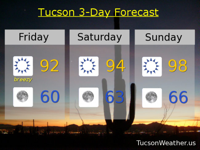
Forecast for Friday, May 26, 2017
It’s Friiiiidaaaayy! Heading into a three day weekend to boot. Another breezy “cool” day before high pressure builds back in for a warmer Memorial Day weekend. Increasing moisture and a weak low will give areas to our east a slight chance of a storm or two by mid next week, but we shall stay high and dry here in Tucson.
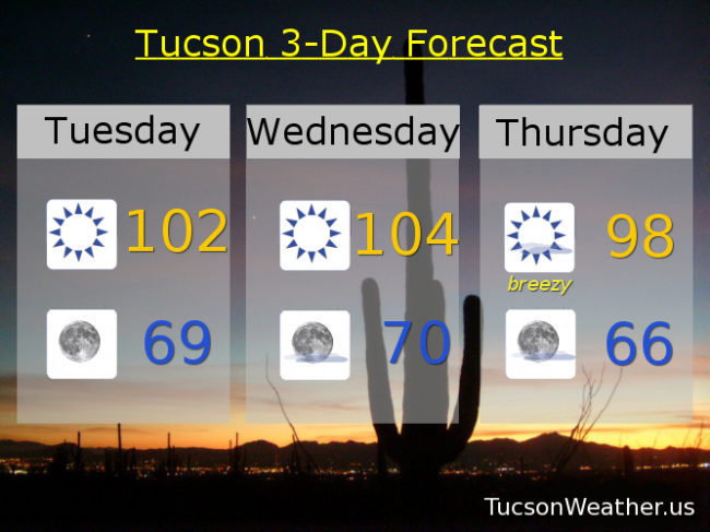
Sunny and breezy today with SW winds 15-25 mph gusting to 35 and a high near 92. Average high for this time of year is 95.
Clear skies tonight with winds relaxing overnight and a low near 60. Average low is 63.
Sunny mid 90s tomorrow. Upper 90s Sunday. Near 100 Memorial Day. Upper 90s Tuesday. Mid 90s Wednesday and Thursday.
Almanac for Thursday, May 25, 2017

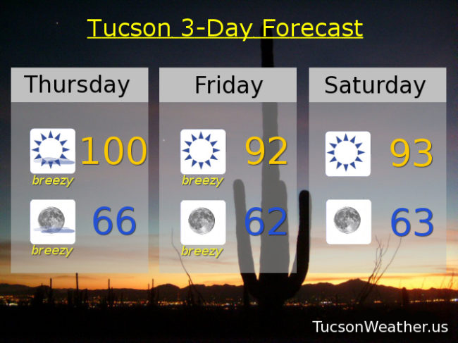
Forecast for Thursday, May 25, 2017
Happy Friday Eve! Makes the weekend seem closer. Which is good because we are gonna have to put up with a bit of wind nonsense between now and then. Fire danger is high so the National Weather Service has issued a RED FLAG WARNING for this afternoon and evening and ditto for tomorrow. Please for the love of everything that is right and good if you smoke keep your butt in the car. Also be careful if you like to set stuff on fire. Maybe resist the urge for a couple of days. Calming down and warming back up for the Memorial Day Weekend! Then a surge (OK, surge is too strong) of moisture moves our way and we have a slight chance of a thunderstorm or two! More thunder than storm so another chance at fires. Stay tuned and stay not on fire!
Mostly sunny and breezy today with SW winds 15-25 mph gusting over 30 and a high near a hunderd.
Mostly clear skies tonight with breezes dying down overnight for the most part and low in the mid 60s.
Sunny and breezy tomorrow with a SW winds 15-25 mph gusting to around 35 and a high in the low 90s. Sunny low 90s Saturday. Upper 90s Sunday. Near 101 Memorial Day. Slight chance for a storm Tuesday near 99. Mostly sunny Wednesday upper 90s.
Almanac for Wednesday, May 24, 2017

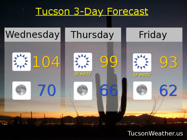
Forecast for Wednesday, May 24, 2017
High pressure hanging out one more day before it weakens and heads south and east. 104 is the record set in 1983 & hit again in 1984 and 2001. Will we add 2017 to the list? If the forecast comes exactly true we will. I’ll let you know how it goes tonight. Then it’s more wind and a FIRE WEATHER WATCH for tomorrow and Friday, so watch out for fires. High pressure begins its return this weekend but with some high cloudiness for possible sunrise and sunset enhancement. Enjoy!
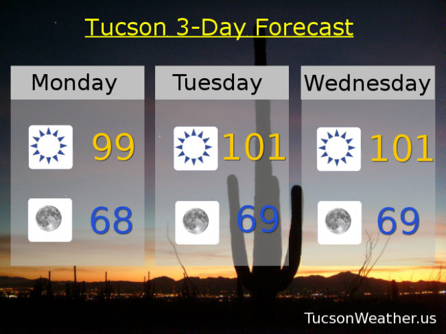
Sunny and hot today with a high near the record of 104.
Clear skies tonight with a low near 70.
Breezy tomorrow with SW winds 15-25 mph gusting over 30 and a high near 99.
Breezy Friday with SW winds 15-25 mph gusting to near 35 and a high near 93. Sunny Saturday low 90s. Mid 90s Sunday. Upper 90s Monday and Tuesday.
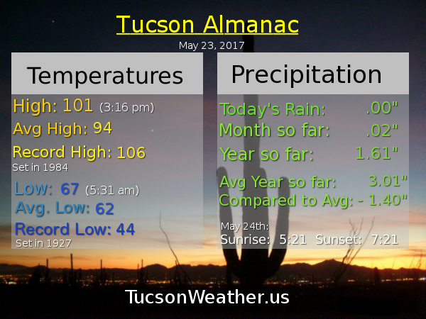
Almanac for Tuesday, May 23, 2017
Forecast for Tuesday, May 23, 2017
It’s BEAUTIFUL this morning! Don’t fall for it. It’s a trick! By this afternoon the blistering Sun will beat down relentlessly bringing heat and blisters (by definition of a blistering Sun) to all who dare stand under its path. Too much? Maybe, but it will be hot the next couple of afternoons. Then a couple of storms missing us to the north will bring breezes that will possibly; blow debris onto my deck from neighboring trees, blow cars around on the roads, mess with your dish reception, blow locusts in from the west, and generally mess up people’s hair. Too much again? Maybe, but a FIRE WEATHER WATCH has been issued for Thursday and Friday afternoon, so watch for fires. It will cool off some, so I guess there’s that. Good Luck!
Sunny and hot today with a high near 102.
Clear skies tonight with a low in the upper 60s to near 70.
Sunny and hotter tomorrow with a high near 104. Breezy Thursday with a high in the high 90s. Breezy Friday with a high in the mid 90s. Low 90s Saturday. Mid 90s Sunday. Upper 90s Monday.
Almanac for Monday, May 22, 2107

Forecast for Monday, May 22, 2017
High pressure large and in charge until Thursday or so when it will start to break down and head east. A couple of storms missing us to the north will then kick up our winds, increase our fire danger, knock down our temperatures, steal our prom date, cause more bad drivers, and blow stuff into the pool. Starting to warm back up by the end of the weekend. Enjoy!
Sunny today with a high near 99.
Clear tonight with a low in the upper 60s.
Sunny tomorrow and Wednesday with highs near 101. Breezy Thursday upper 90s. Breezy Friday low 90s. Sunny Saturday low 90s. Mid 90s Sunday.