Monthly Archives: May 2020

Forecast for Saturday, May 30, 2020

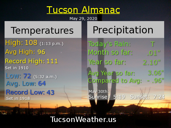
108 yesterday! The record was 111 so it could have been worser. (the old starving kids in China argument, but it is good to be grateful) A trace of rain at the airport yesterday as well, so there’s that. It just gets better from here! (until it gets worser again) An EXCESSIVE HEAT WARNING is still in effect today and tomorrow, so be warned, the heat will still be excessive. But hey. You survived yesterday! It’s not gonna be as bad as that and improving as we go. Let’s take a look, shall we?

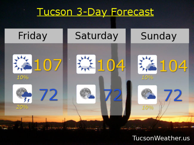
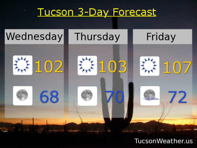
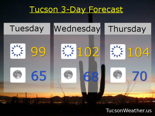
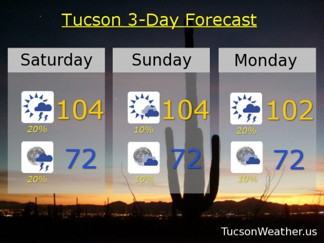
Mostly sunny and hot today with a high of 104 and a 20% chance for afternoon and evening storms! Storms (hopefully near you) ending tonight with a low in the low 70s. 10% chance for a storm maybe tomorrow 104. 20% Monday 102 para tu. 10% Tuesday 101. Sunny Wednesday 103. 99 (I’ve been waiting so long) Thursday and Friday. Be Cool 😎

Forecast for Friday, May 29, 2020

It’s Friiidaaay!!! It’s also hot… but not that hot. Let me explain.

The EXCESSIVE HEAT WARNING continues through Sunday, so yeah, the heat IS excessive. However. Even though today should be the hottest in our string of hot highs expecting to top out at 107, today’s record is 111! (the exclamation point is not another 1 🙂 ) So. It’s all good. Also a 10% chance for a storm this afternoon doubling to a 20% chance this evening!

Low 70s to start the day tomorrow with a high of 104. 104 Sunday with a 10% chance for a storm. 10% Monday 101. 20% Tuesday upper 90s. 10% Wednesday upper 90s. Sunny Thursday upper 90s. Be Cool!

Forecast for Thursday, May 28, 2020

Happy Friday Eve! Makes the weekend seem closer, you know…

I’ll take “heat modifiers” for $500 Alex. What is, scorching, blazing, oppressive, sweltering, dry, ridiculous, seasonal, and excessive. Not an exhaustive list by any means and you can add yours in the comments if you like. The National Weather Service has gone with excessive, as in an EXCESSIVE HEAT WARNING today through Sunday. Be warned. The heat will be excessive. All is not lost. Enough moisture around for a slight storm possibility (hopefully near you) Friday night and Saturday. Sunday night through Tuesday too. Details details…

Sunny today with a high of 104. 70ish tonight. 107 tomorrow with a 20% chance for a storm or three Friday night. 10% chance Saturday 105. Mostly sunny Sunday 105. 10% chance Monday 102 para tu. 20% Tuesday upper 90s. 10% Wednesday 99 (I’ve been waiting so long). Be Cool!

Forecast for Wednesday, May 27, 2020

Mike Mike Mike Mike Mike. What day is it Mike? It’s EXCESSIVE HEAT WARNING Eve. That’s what day it is.

Yep. The watch has become a warning, so be warned, the heat will be excessive. The EXCESSIVE HEAT WARNING starts tomorrow and runs through Sunday! So yeah. Hot. Makes sense I guess. June approacheth…

Sunny today and 102 para tu y tu y tu y tu… Clear skies tonight upper 60s. 103 tomorrow. 107 Friday! 105 Saturday and Sunday. 101 Monday. Upper 90s Tuesday. Be Cool

Forecast for Tuesday, May 26, 2020

Heat so excessive the National Weather Service has expanded the EXCESSIVE HEAT WATCH from Thursday now through Saturday. Watch out! The heat will be rather excessive. Comfortable in the morning though. One of the benefits of a dry heat.

99 (I’ve been waiting so long) this afternoon with nuttin’ but Sun. Mid 60s tomorrow morning. 102 para tu manana. 104 Thursday. 106 Friday. 105 Saturday. 104 Sunday. 101 Monday. Be Cool!