Monthly Archives: November 2019

Forecast for Friday, November 29, 2019

Here comes a cold front! If it hits you like it did us here in Phoenix at 4:00 a.m., look out! I swear a couple of trees were gonna blow down! They didn’t, but wow, that was exciting! Good thing standing in long lines at 4:00 a.m. for Black Friday isn’t a thing anymore. (is it?) Either way, strong winds ahead of the front and as it passes this morning. Still expecting valley rain and massive mountain snow today. .5″ to 1.5″ inches of rain possible. 1 to 2 feet of snow above 7,000 feet (I’m looking at you Summerhaven) and 3 feet or so at Ski Valley. Exciting times!

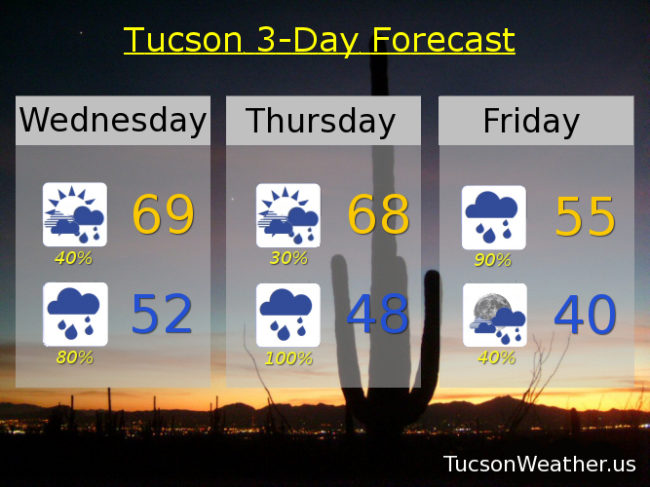
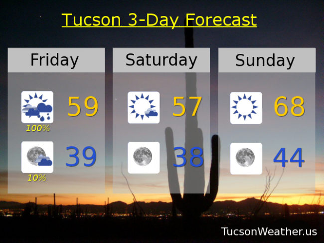
FLASH FLOOD WATCH in effect until 5:00 this evening and a WIND ADVISORY until 2:00 this afternoon, so be advised, it’s windy. Wind gusts over 30 mph with a 100% chance of rain. Winnie the Pooh and the Blustery Day would be proud. (silly ol’ bear) Today’s high in the upper 50s.

Clearing skies by tonight if not sooner with perhaps a lingering shower and a low in the upper 30s.

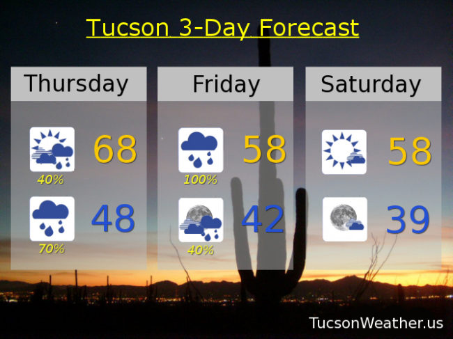
Cool tomorrow after that chilly start (mmm chili) and a high in the upper 50s.

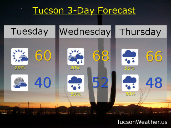
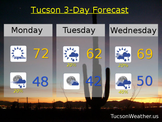
Sunny Sunday upper 60s. Low 70s Monday. Partly sunny Tuesday low 70s. A 20% chance for showers Wednesday near 70ish. 30% Thursday upper 60s. Enjoy!

Forecast for Thursday, November 28, 2019

Happy Thanksgiving! I can smell your roasting turkey from here. Amazing! Is it irony or coincidence that turkeys go “gobble gobble gobble”? What time is dinner? 🙂

Our Winter storm approacheth with wind and rain and literally tons of mountain snow. (seriously. If you weigh all the snow it will easily weigh tons) The associated cold front with our approaching storm is currently in western Arizona. It will hang out there through this afternoon before heading east and moving through these parts tonight. Winds and rain chances will increase as it gets closer and moves through. Snow levels are currently around 8,000 feet. Those will slowly sink to 7,000 feet and then down to 5,000 feet by tomorrow morning. 6 inches of snow or so possible above 6,000 feet. 1 to 2 feet perhaps above 7,000. Could see 3 feet or more at Ski Valley! Just epic if it comes true. For Summerhaven a FLASH FLOOD WATCH is in effect from 5:00 tonight until 5:00 tomorrow night. A WIND ADVISORY begins at 11:00 tonight and ends at 2:00 tomorrow afternoon. Be advised, it’s gonna be windy with winds gusting to 60 mph to blow that heavy snow around! A WINTER STORM WARNING is in effect from 11:00 tonight until Noon tomorrow. If I could afford a cabin up there I’d head up today, start a fire in the fireplace, and enjoy the show!

This is Tucson Weather, so let’s go over the 411 for the Old Pueblo. A 40% chance for showers this morning otherwise mostly cloudy today with a high in the upper 60s.

A FLASH FLOOD WATCH begins tonight at 11:00 and lasts until 5:00 p.m. tomorrow. Cloudy tonight with showers likely. A WIND ADVISORY from 11:00 p.m. tonight until 2:00 tomorrow afternoon. Winds tonight out of the south 25-35 mph gusting to 50! Low in the upper 40s.

Heavy rain possible with wind tomorrow. In other words, quite blustery! WSW winds 20-25 mph gusting over 35. The rain should start to taper off by afternoon but still breezy with showers about. High in the upper 50s.

Scattered showers Friday night before midnight becoming partly cloudy by Saturday morning. The Sun returns Saturday with a few clouds and a high in the upper 50s. Sunny Sunday 68ish. Partly sunny Sunday and Monday low 70s. Scattered showers Wednesday as our next storm moves in! High in the upper 60s. Enjoy!

Forecast for Wednesday, November 27, 2019

‘Twas the day before Thanksgiving and all through the store, people were shopping for turkeys and more. The guest rooms prepared and beds made with care. All in anticipation of in-laws staying there. The cranberry sauce in the can is the worst. Seriously, I’d much rather have bratwurst! The rhythm of the rain will exceed the cadence of this poem. Heavy at times and maybe a storm. Winter has arrived in time for Thanksgiving! If you like weather it’s a great time for living.

It’s a tale of two storms. Heavy rain and massive mountain snow still expected. Lots of wind as well. If you have hatches, batten them down! One change in the forecast is mainly for today. An upper level low off the Baja California coast is pulling moisture northward. Originally the thinking was that mainly Cochise County would get in on this initial action. It appears now that Tucson may be included. Look for a decent chance for rain today with increasing clouds and a high in the upper 60s.

A better chance for rain tonight with a low in the low 50s.

A bit of a break tomorrow as our second storm appraocheth. Still a few showers around in the morning with mostly cloudy skies all day. Breezes picking up as well gusting to around 25 mph and a high in the upper 60s.

Prime time for our Winter storm is Thanksgiving night into Friday. A FLASH FLOOD WATCH is in effect from 11:00 a.m. Thanksgiving until 5:00 p.m. Friday. Rain, heavy at times, possibly a few thunderstorms, and windy. Winds gusting to near 40 mph. A WIND ADVISORY is in effect from 11:00 p.m. Thursday until 2:00 Friday afternoon. Friday’s high in Tucson a rain soaked 55ish.

The mountains will be hit hard with this storm. Heavy rain changes to heavy snow in Summerhaven Thanksgiving evening and it will be coming down! A FLASH FLOOD WATCH, WINTER STORM WARNING, and WIND ADVISORY all in effect from various times starting tomorrow into Friday. Winds could gust to 55 mph with 15″ to 25″ of snow expected in Summerhaven! Could see 3 feet at Ski Valley!!!

The storm starts to move out Friday night with lingering showers. Clearing out Saturday and cool with a high in the upper 50s. Sunny Sunday upper 60s. Low 70s Monday and Tuesday. Perhaps another storm late next week! But we’ll burn that bridge when we get to it. Stay tuned!

Forecast for Tuesday, November 26, 2019

A major Winter storm is forming and will be making a Thanksgiving visit. Always nice to have guests drop by for a festive feast! It’s a cold storm and the main headline will be the massive snow totals above 7,000 feet. Could see 3 feet of snow at Ski Valley!!! Winds gusting 50 to 60 mph in the high country could lead to white out conditions at times. Not to mention falling trees to go with their sideways snow. If it weren’t for Rudolph, Thanksgiving might be cancelled. (sorry. I got ahead of myself there) Honorable mention weather headline goes to Cochise County. Lots of moisture being pulled northward ahead of the system. A cold front approacheth and should move through today. The combination could bring heavy rain east of Tucson. Just be aware if you are heading that way. Today’s aforementioned front will chill us out a bit in Tucson with a high about 10 degrees cooler than yesterday. A few showers out there this morning that should end by 8:00 a.m., so there’s that.

Increasing clouds tonight with a low near 40ish.

Mostly cloudy with a few showers around tomorrow upper 60s. Cloudy tomorrow night and Thanksgiving with a 50% chance for rain. Thursday’s high in the mid 60s.

Prime time for our storm should be Thursday night into Friday morning. A WINTER STORM WATCH for Summerhaven starting at 6:00 p.m. Thursday until Midnight Friday night. Summerhaven could see half a foot to a foot of snow along with those 50-60 mph winds.

Looks like a good soaking for us lowlanders. Blustery Thursday night and Friday with rain, heavy at times, possible. Valley locations looking for an inch to an inch and a half of rain. Amazon Prime is looking good for Black Friday! Nothing like shopping in the comfort of your own home while others hydroplane to Best Buy for that 75″ TV on sale for $400. (wait. Is that a thing?) Friday’s high in the upper 50s.

The rain will mainly be on the wane Saturday becoming mostly sunny with a high in the upper 50s. A slow warming trend Sunday and Monday with sunshine and highs mid to upper 60s respectively. Stay tuned. We’ll keep you updated as the storm gets closer. What else do I have to do at 5:00 in the morning? 🙂

Forecast for Monday, November 25, 2019

Over the wash and past the Saguaro to Grandmother’s house we go! A lot to be thankful for as we hunt and gather our Turkey with all the fixin’s from the meat and produce section of Costco. After a nearly picture perfect weekend our Winter storm approacheth, and as it does our chances of rain and mountain snow increasingeth. The Thanksgiving storm should stick around for Thursday’s feast, Friday’s shopping frenzy, and into the leftovers weekend. Looks like an inch or two of rain for most valley locations before the storm bids us adieu. Snow levels crashing down to near 4,000 feet by Friday morning! Could see 5″ to 15″ between 5,000 and 7,000 feet and 15″ to 30″ above that! Significant mountain snow indeed! Here’s your forecast from the kids table:

Considerable high cloudiness continues today. Call it partly sunny with a high near 72ish.

Mostly cloudy tonight with a slight chance for showers after midnight and a low in the upper 40s.

Slight chance for showers tomorrow morning otherwise partly cloudy and a high in the low 60s.

Mostly cloudy with a 20% chance for showers Turkey Eve day upper 60s. Scattered showers Thanksgiving day with a high in the mid 60s. Heavy rain possible Thursday night mid 40s. Rain likely Friday upper 50s. Isolated showers Saturday mid 50s. Sunny Sunday near 60ish. Stay tuned as the developing storm situation develops…