Monthly Archives: January 2020

Forecast for Friday, January 31, 2020

It’s Friiidaaay!!!

Snow is in the forecast! For reals. In town even. But first. The weekend looks AMAZING! You know, if you’re into sunshine and 70s in February. A cold storm currently on an Alaskan cruise in the Gulf of Alaska will take a dive south into northern Arizona Monday into Tuesday. Moisture is expected to move up from the south. As the colder air pours in Monday night/Tuesday we should see snow mixing in with the rain showers or just becoming snow showers. Light accumulations possible even! Of course we’ll keep you updated. As you may know I’m moving to Lubbock, Texas tomorrow, but they actually have the internet there. (I know, right?) So keep it locked on Tucson Weather! Together we’ll keep this party going…

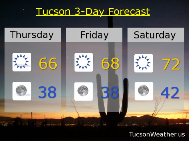
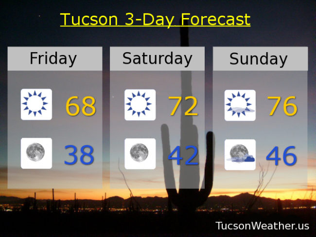
Sunny today and a bit warmer than yesterday with a high in the upper 60s. Clear skies at night upper 30s by morning. Sunny low 70s tomorrow. Mostly sunny mid 70s Sunday!

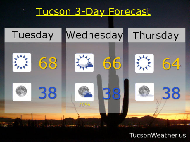
Let the games begin on Monday. Partly sunny and breezy (windy prolly) with a 30% chance for showers and a high near 60ish. A chance for rain and snow showers Monday night low 30s. A 20% chance for rain and snow Tuesday with a high only in the upper 40s. Clear and cold Tuesday night with a low in the mid 20s! We will rebuild. Sunny low 50s Wednesday. Near 60ish Thursday. Enjoy!

Forecast for Thursday, January 30, 2020

37 degrees with a wind chill of 33 at 5am is not warm. You might even call it chilly! (mmm chili) Patchy fog possible this morning as well. We’ll be Walkin’ on Sunshine today (is that safe?) with a high in the mid 60s. Warmin’ up this weekend! Upper 60s tomorrow. Low 70s Saturday. Upper 70s Sunday!

A fast moving storm will bring a chance for rain Monday and maybe some snow mixed in Tuesday morning! Not a ton of moisture expected with this system. Guestimates this far out say about a quarter inch of rain in the valley and around 6 inches of snow for Summerhaven. (give or take) It will be breezy to windy, so there’s that. We (me) at Tucson Weather will keep you posted as we get closer. For now we’ll broad brush it and say mostly sunny and breezy/windy Monday with a chance for rain showers mid 60s. Slight chance for rain/snow showers Tuesday morning. High Tuesday afternoon only in the low 50s. Clear and cold Tuesday night with a low near 30ish! Sunny and cool Wednesday upper 50s. Stay tuned!

Forecast for Wednesday, January 29, 2020

It’ll be hard to tell, but a weak and dry storm will be moving through tonight. Perhaps a bit breezy this afternoon, but a lot of sunshine today and cool like yesterday. High in the mid 60s. A slight chance for light rain tonight and maybe an inch or two of snow above 7,000 feet (I’m looking at you Summerhaven), but clearing out by morning and chilly (mmm Chili’s) with a low in the upper 30s.

Cooler behind the storm tomorrow with sunshine low 60s. (it’s tough being the cool kids) Warming up for the weekend! Mid 60s Friday. Low 70s Saturday. Mid 70s Sunday.

A storm appraocheth for next week! We can make it colder, stronger, and wetter. (the Steve Austin storm? let’s go with it!) We’ll have to keep an eye on this one as snow levels will be quite low with a decent shot for cold rain and low mountain snow. We’ll know more as it gets closer. (and even more after it’s done!) Right now let’s call it mostly sunny and breezy Monday with a 20% chance for showers and a high in the low 60s. A slight chance for rain and snow showers Tuesday (you read that right. that is a quote from the official NWS forecast) with a high in the mid 50s. Stay Tuned!!!

Forecast for Tuesday, January 28, 2020

So you’re saying there’s a chance?! No. Not really. A tale of two systems on this Twofer Tuesday. The first one moving through yesterday cooling us off to an average high for this time of year of 67. We’ll be close to that again today. The second system is starved for moisture, but maybe it’ll squeeze out a few drops tomorrow night. Maybe. Then it’s sunshine with a warm up just in time for a super weekend. Looks like another storm by Monday. Details details…

Sunny today with a high in the upper 60s. Upper 30s to start the day tomorrow. Partly cloudy tomorrow afternoon mid 60s. Slight chance for light rain (half the calories of our regular rain) tomorrow night upper 30s. Sunny mid 60s Thursday. Upper 60s Friday. Low 70s Saturday. Partly sunny Sunday mid 70s. Slight chance for showers and breezy Monday low 70s. Enjoy!

Forecast for Monday, January 27, 2020

Come Monday it’ll be all right… cooler, but alright. Kinda cloudy this morning but those clouds will disappear (magic!) and we’ll be left with sunshine and a high in the upper 60s. Upper 30s to start the day tomorrow. Sunny upper 60s again tomorrow afternoon. A few more clouds and cooler again on Wednesday mid 60s. Sunny mid 60s Thursday. Upper 60s Friday. Low 70s Saturday. Upper 70s!!! Sunday! Enjoy 🙂