Tag Archives: Winter Weather Advisory

Forecast for Monday, February 10, 2020

Rainy Dayz and Monday always get me excited!

An upper level low will be tracking acrosst southern Arizona through tomorrow. A great chance for rain and maybe even a few thunderstorms. A WINTER WEATHER ADVISORY above 7,000 feet for 6 to 12 inches of snow. (Summerhaven Winter Wonderland!) Prime time for the storm will be this evening into tomorrow. A couple days to warm up after the storm with another approachething (albiet weaker) for the weekend! Stay tuned and stuff.

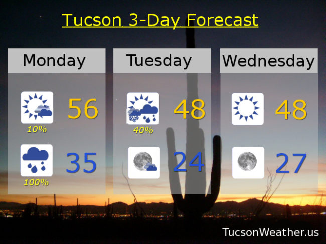
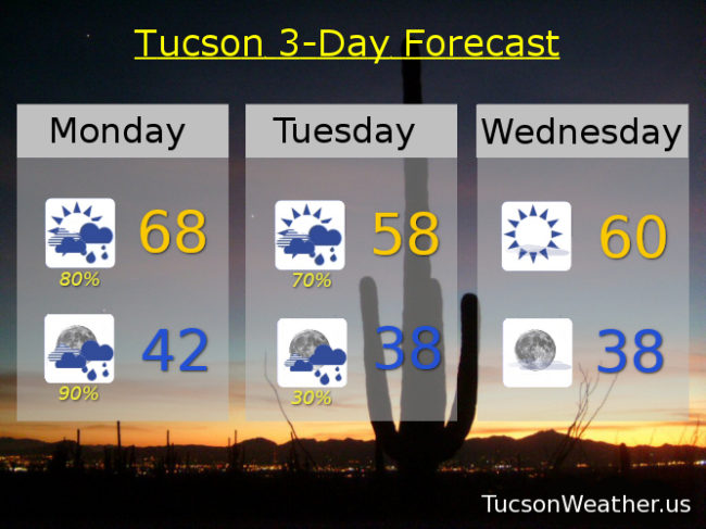
Showers today and possibly a thunderstorm and a bit breezy. SW winds 5-15 mph and gusty. High in the upper 60s. Rain likely tonight and perhaps a thunderstorm and a low in the low 40s. Showers likely tomorrow with a high in the upper 50s.

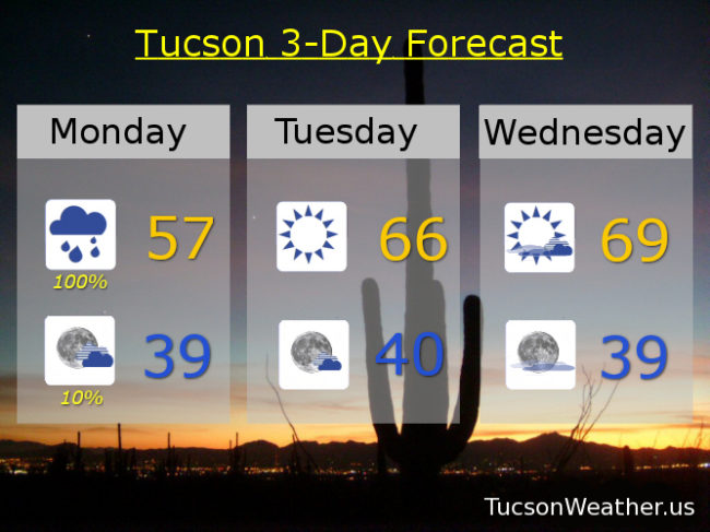
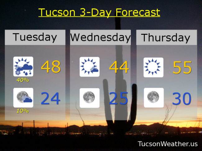
Sunny Wednesday in betwixted storms with a high near 60ish. Upper 60s Thursday. Near 70ish Friday. 20% chance for showers with a high in the mid 60s. Mostly sunny Sunday with a slight chance for a shower upper 60s. Enjoy!

Forecast for Monday, December 9, 2019

Rainy dayz and Mondays never get me down! I mean, yeah, it’s Monday, but rain makes it all better. An upper level low currently off the California coast is approachething. As it draws neigh showers and perhaps a few thunderstorms will continue off and on into the afternoon. Snow levels currently way up there above 8,000 feet. They will be coming down to about 7,000 this morning. So. The National Weather Service has issued a WINTER WEATHER ADVISORY above 7,000 feet until 5:00 this evening. Be advised. There will be Winter weather. 2 to 4 maybe more inches of snow for Summerhaven. The low should be to our south and east by tonight with rain on the wane.

Cloudy today with showers and maybe a few storms. Heavy rain possible at times for some. High in the upper 50s.

Clearing skies tonight with perhaps a lingering shower. Chilly (mmm chili) by morning with a low in the upper 30s.

Sunshine returns tomorrow with a high in the mid 60s. Partly sunny Wednesday upper 60s to near 70ish. Sunny Thursday upper 60s. Low 70s Friday and Saturday. Near 70 Sunday. Enjoy!

Forecast for Tuesday, January 1, 2019

Happy New Year! Baby 2019 has arrived. Some snow down low as well! Catalina. Corona de Tucson. Vail. All with snow on the ground to start the New Year. Snow showers reported since early this morning in parts of the Metro. It is snowing right now at the airport! Although I am a bit disappointed that I don’t have snow on the ground here in southern Oro Valley it sure is pretty so low on Pusch Peak with my coffee on the deck this morning. Hope springs eternal for the New Year with such a special start!

Rain and snow showers remain in our forecast as our low continues to sink to the south. WINTER WEATHER ADVISORY in effect until 10:00 a.m. Could see some accumulations perhaps. I’m hoping for a snow shower selfie at least! Isolated rain and snow showers lingering into tonight, but our attention turns to the COLD. HARD FREEZE WARNING for tonight and tomorrow night. Lows both nights in the mid 20s! Even down to near 30ish Friday morning. My outdoor plants have become indoor plants. I’m a little concerned they may be getting used to the good life! Warming to near normal highs Friday and Saturday afternoons before we welcome our next storm system. This one looks to be quite a bit warmer with a good chance for rain Sunday and Sunday night. Stay tuned!

Scattered rain and snow showers this morning before Noon. Scattered rain showers from Noon until about 4:00 p.m. Scattered rain and snow showers after 4:00. High today in the upper 40s. Isolated snow showers perhaps before midnight with mostly cloudy skies and a low in the mid 20s. Partly sunny tomorrow morning with clearing skies and high only in the mid 40s! Mid 20s Thursday morning and mid 50s Thursday afternoon. Sunny Friday mid 60s. Partly sunny Saturday mid 60s. 30% chance for rain Saturday night. 40% Sunday upper 50s. 50% Sunday night low 40s. 20% Monday low 60s. Enjoy!

Forecast for Monday, December 31, 2018

Our winter storm approacheth! Already some winds kicking up out there. It will be a “breezy” day with south winds gusting over 30 mph. Increasing clouds with a slight chance for showers this afternoon even. Rain begins in earnest (and Tucson too) tonight with the National Weather Service giving us a 100% chance for rain! 💯 Rain mixing with or changing to snow New Year’s morning with a WINTER WEATHER ADVISORY in effect above 3,500 feet from 5:00 p.m. tonight until 5:00 p.m. tomorrow night. I’m looking at you Catalina, Vail, and Corona de Tucson! Maybe an inch or so of snow for y’all! What a great way to start the year if we could manage snow showers in and around Tucson tomorrow morning! Meanwhile in the mountains it’s a WINTER STORM WARNING from 2:00 this afternoon until 5:00 p.m. tomorrow. Summerhaven expecting 1 to 2 feet of snow!!!

All of this excitement is followed up by a HARD FREEZE WARNING for the Metro starting tomorrow night at 10:00 p..m. until 9:00 a.m. Wednesday morning. Mid 20s expected! Hopefully no more flies on my hikes. For those of you sick of the cold, take heart. Warming up to near average (mid 60s) by Friday and Saturday. Another Storm in here by the end of the weekend but it looks like snow levels high enough to maybe even melt some mountain snow. Stay tuned!

Increasing clouds and breezy today with south winds 15-25 mph gusting to near 35. 10% chance for showers this afternoon and a high in the mid 50s. 100% chance for showers tonight with snow possible above 3,500 feet and a low in the mid 30s. Scattered rain and snow showers tomorrow morning followed by scattered rain showers with decreasing clouds late and a high in the upper 40s. Mostly clear Tuesday night/Wednesday morning with a low near 24ish! Sunny Wednesday upper 40s. Upper 50s Thursday. Mid 60s Friday and Saturday. 40% Sunday upper 50s. Enjoy!