Monthly Archives: September 2018

Forecast for Sunday, September 30, 2018

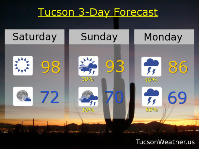
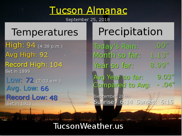
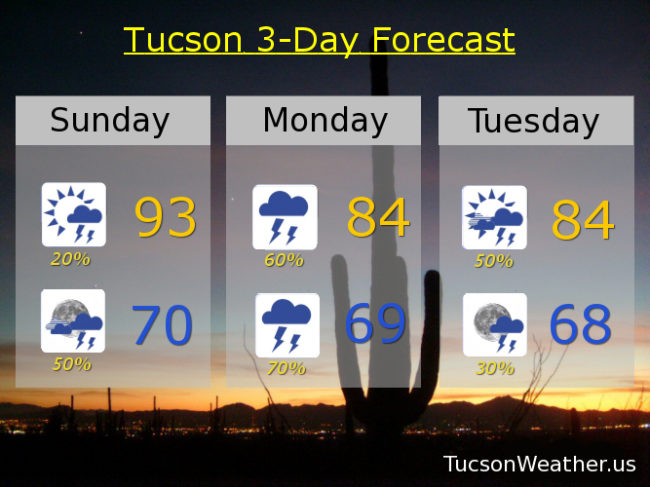
Here comes Rosa! Well, the moisture ahead of Rosa is arriving first. A few high clouds already increasing this morning with rain likely developing near the International Border SW of Tucson a little later. Moisture and rain chances then continue to spread north and northeast through the day. A little cooler today than the 98 degrees (wasn’t that a boy band back in the day?) the last three days with a high in the low 90s. Showers and storm chances at 20% today increasing to 50% by tonight. Tonight’s low near 70.

Tomorrow looks to be a cloudy, cool, rainy day with locally heavy rainfall possible. The heavy rain is more likely to the west (closer to Rosa’s leftover circulation) and in the mountains. Breezes picking up tomorrow night too (gusting to 30 mph) as Rosa passes to our west. Call it a 60% chance for showers and storms tomorrow and a 70% tomorrow night with highs in the mid 80s and lows in the upper 60s.

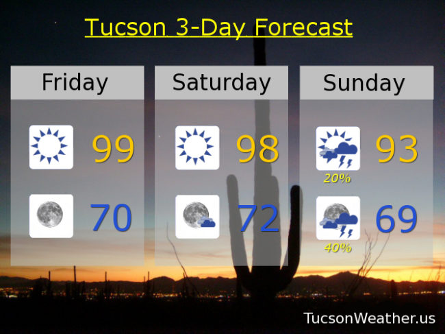
Partly sunny and breezy on Tuesday with SSW winds gusting to 30 mph. A 50% chance for showers and storms with a high in the mid 80s.

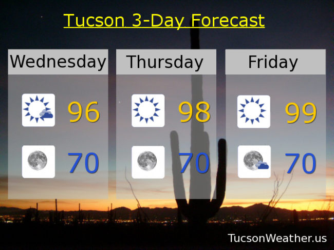
A series of troughs moving through Arizona the rest of the week will keep us on the cool side with a chance for a few showers. 20% Wednesday upper 80s. 10% Thursday mid 80s. Mostly sunny Friday mid 80s. Mostly sunny and breezy Saturday mid 80s. Lows in the low to mid 60s!!! Enjoy!

Forecast for Saturday, September 29, 2018

Very refreshing on the patio/deck/roof this morning. Currently 70 at 5:35. Nice!  High pressure remains parked over our head for another day with a high today near 98.

The times they are a changin’! A gift from the tropical waters off the Mexican Coast, Hurricane Rosa is making a beeline for SW AZ. Clouds and moisture on the increase through the day tomorrow with a good chance for showers and storms by afternoon/evening. High in the low 90s.

Monday looking cloudy and rainy with embedded thunderstorms, some with locally heavy rainfall, and a high in the mid 80s. The main event should be Monday night into Tuesday as the much weakened circulation from Rosa moves just to the west and then north of Tucson. Numerous showers and storms Monday night and Tuesday along with increasing breezes. Could be fairly windy in the mountains! Monday’s high in the mid 80s. 50% chance for rain Tuesday mid 80s. There is a FLASH FLOOD WATCH in effect for central Pima County and Pinal County Monday morning through late Tuesday night. If Rosa’s path should move just a bit more to the east then forecast, the watch may be updated to include the Metro. Stay tuned.

A trough of low pressure moves through the state Wednesday bringing a slight chance for showers as it moves through. Continued cooler than average to start October. 20% chance for showers Wednesday mid 80s. 10% Thursday mid 80s. Sunny Friday mid 80s. Enjoy!

Forecast for Friday, September 28, 2018

It’s Friiidaaay!!!

Monsoon 2018 winding it down. Any rain that falls before Sunday at midnight counts towards the official total. Last minute Monsoon rains may happen at, um, the last minute! But first, we have to get through a day or two of flirting with 100. (Hey Monsoon, quit flirting with Summer. There’s nothing there for you except pain and regret) 99 yesterday and 99 expected today. Upper 90s tomorrow before Hurricane Rosa heads our general direction.

Clouds and moisture on the increase Sunday with a chance for scattered storms by afternoon/evening. As Rosa moves our way and weakens the chances for rain, and locally heavy rain, increases. A 40% chance for storms Monday and a 50% chance for storms Monday night. Winds increasing Monday night as well, especially for higher elevations. Monday’s high in the mid 80s. Showers likely Tuesday with a 60% chance for showers and storms. Breezy with a high in the mid 80s. 20% Wednesday mid 80s. 10% Thursday mid 80s.

The heaviest rains are still forecast to be to our west and in the local mountains. A small change in Rosa’s track could make big changes in the forecast. Stay tuned!

Forecast for Thursday, September 27, 2018

Happy Friday Eve! Makes the weekend seem closer. It is AMAZING out there right now for coffee on the patio/deck/roof/lawn/outside seating. Right around 70 right now (5:35 a.m.). Sunny warm days and cool mornings continue through most of the weekend with highs in the upper 90s to near 100 and lows in the low 70s through Saturday.

Meanwhile, all eyes are on Hurricane Rosa. She is expected to make a turn to the north and then north-northwest and move into northern Baja California by around Monday. She’ll weaken to a Tropical Storm by then, but she’ll be carrying tons of rich, soupy, tropical moisture. Her exact track into the SWestern US is still a bit uncertain, but someone in Arizona is probably gonna get 2 1/2 inches of rain! Right now that looks most likely to our west. Tons of moisture moving in area wide, so even if we don’t get the most soaked we should still have scattered showers and storms. We’ll keep you posted of course.

So the rest of the forecast looks like this. A 10% chance for rain Sunday low 90s. 30% Sunday night upper 60s. 30%/50% Monday upper 80s. 40%/20% Tuesday, breezy upper 80s. 20% Wednesday upper 80s. Stay tuned!

Forecast for Wednesday, September 26, 2018

High pressure building in the next few days with highs today in the mid 90s then upper 90s (100?) Thursday, Friday and Saturday. A bit cooler on Sunday with a high in the mid 90s. Morning lows near 70 for that perfect cup of coffee on the patio, deck or roof.

Interesting times as we start October. Looking at a lot of moisture lurking to our south with a pretty good chance it will head our way! High pressure moving a bit to the east. A trough in the west. That may help funnel moisture northward. Add what will soon be Hurricane Rosa that should start to move north helping with an extra moisture push! If all this comes true we’ll have plenty of juice for showers and storms. Still a ways out, so we’ll keep you posted. Right now the National Weather Service is saying a 20% chance for storms Sunday night. 40% Monday low 90s. 30% Tuesday upper 80s. Stay tuned!