Monthly Archives: February 2020

Forecast for Saturday, February 29, 2020

It’s a Leap Day Saturday! Google tells me that Leap Day is not only a day where women propose to men, but the men aren’t suppose to say no! If they do they are expected to pay a fine to the woman such as a gown or money. Sounds like that system could be open to abuse. Gown diggers instead of gold diggers? Be careful ladies. You may get stuck with the man you don’t want instead of the gown you do! Leap Day babies age much slower than the rest of us. A bunch of 4 year olds getting their drivers license sounds sketch, but it’s a thing. In any event it’s nice to know we get an extra day every four years to keep the calendar on track. Speaking of track (and I think we were) our storm is still on track to bring us a cold valley rain and some mountain snow Monday into Monday night. If the above mentioned storm track is a bit too far south we may miss out, but right now it looks like a go! Forecasts can and do change, so stay tuned!

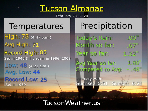
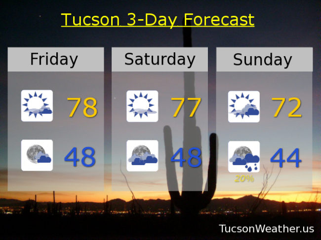
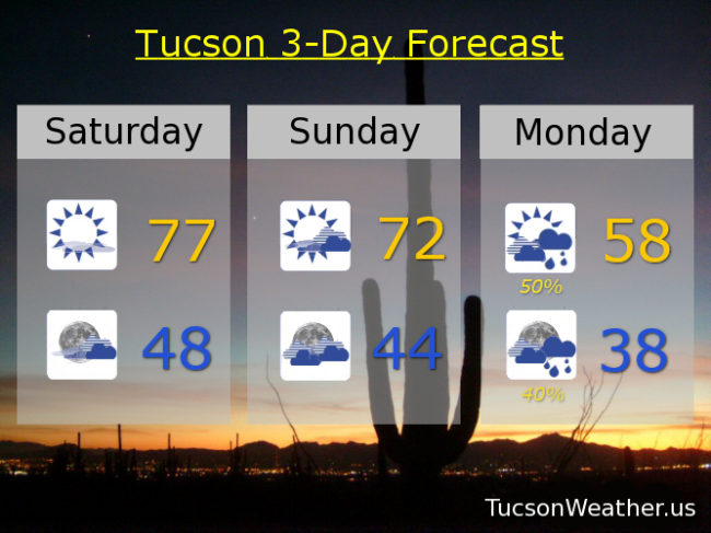
Some high cloudiness around today for possible sunrise and sunset enhancement. Call if mostly sunny and nice with a high once again in the upper 70s (it was 78 yesterday). Mostly cloudy tonight upper 40s. Partly sunny and breezy tomorrow with WSW winds 5-15 mph and gusty low 70s.

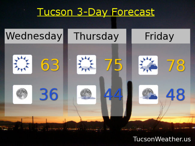
Showers should commence by Monday afternoon with a high in the upper 50s. Snow level could go as low as 4,500 feet Monday night, but not much accumulation expected that low. Perhaps a few inches of snow above 6,000 feet. A chilly rain (mmm chili) in Tucson with a low in the upper 30s. Slight chance for lingering showers Tuesday mid 60s.

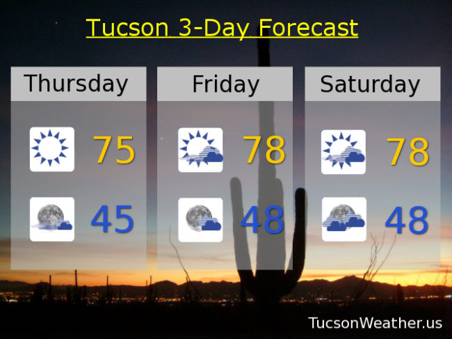
Clearing out and warming up after the storm skedaddles. Sunny Wednesday low 70s. Upper 70s Thursday. Near 80ish Friday. Enjoy!

Forecast for Friday, February 28, 2020

It’s Friiidaaay!!!

Let the weekend commence! And what a weekend it will be. Since tomorrow is Leap Day it’s like getting an extra day! Instead of waxing all philosophical about having an extra day to spend with love ones, doing good, or playing Minecraft, here is another way of looking at it. If you get paid on the 1st and the 15th of the month it’s an extra day you’ll have to wait until Pay Day. (I hate when that happens) Also, my understanding is that women chase the men during Leap Years? Is that a thing? Asking for a friend 🙂

But I digress. Let’s chase some weather and see where we end up. Partly sunny today upper 70s. Mostly sunny upper 70s tomorrow. Partly sunny Sunday low 70s.

Our next storm approacheth and by Sunday night we could see a few showers bust out. Certainly by Monday. Monday’s high only in the upper 50s. Snow levels down as low as 4,500 feet. Not a lot of moisture with this storm. Only a few inches of snow in the mountains and up to a quarter inch of rain in the valleys. Perhaps a lingering shower Tuesday otherwise call it mostly sunny near 60ish. Sunny near 70ish Wednesday. Mid 70s Thursday. Enjoy!

Forecast for Thursday, February 27, 2020

K-Tel presents. The Return of the 70s! Enjoy all the hits from Neil Sedaka, The Carpenters, Neil Diamond (what’s with all the Neils?), CCR, BTO, Dan Fogleberg, and of course Linda Ronstadt while you frolic in the park or tell the merging impaired on I-10 that they are number 1. No matter how you fritter away (mmm fritters) your time through the weekend, the Return of the 70s will probably make it suck a little less. Who knows. It might even be fun! A storm approacheth. That will bring us more clouds starting tonight, culminating with rain and mountain snow Sunday night through Monday night. Put the needle on the record. Let’s Rock this forecast!

Sunny today mid 70s. Increasing clouds tonight mid 40s. Partly sunny tomorrow and Saturday upper 70s. Low 70s Sunday. Rain showers commence Sunday night into Monday lingering into Monday night. Monday’s high only in the mid 50s! Sunny Tuesday low 60s. Mid 60s Wednesday. Enjoy!

Forecast for Wednesday, February 26, 2020

Mike Mike Mike Mike Mike. What day is it Mike? It’s a skirt alert, hold on to your hats, put rocks in your pockets, if it isn’t tied down it’s blowin’ toward California day. That’s what day it is. (too dramatic? yeah maybe) The wind will be blowin’ out of the east 15-20 mph gusting to near 30. Today’s high only in the low 60s. Winds relaxing tonight but still out of the east 10-15 with a low in the mid 30s.

Then it’s the good stuff! If you like the 70s. Mostly sunny tomorrow mid 70s. Partly sunny Friday upper 70s. Mostly sunny Saturday upper 70s. Partly sunny Sunday low 70s.

A storm approacheth that will bring valley rains and mountain snows to all the good little boys and girls of southern Arizona. The chance for showers starts Sunday night and increases on Monday with a high in the low 60s. Slight chance for showers lingering into Tuesday low 60s. Enjoy!

Forecast for Tuesday, February 25, 2020

I bet your high school yearbook says you were likely to be slightly cooler than average. 😎 Certainly we are living in such a time. You know. Until Thursday. Then it’s time for the above average to much above average folks to shine! Early next week is for those of you who were voted, “most likely to crash snow levels” as a cold storm system heads our way. OK weather nerds, let’s take a closer look at the forecast!

Sunny and breezy fo’ sheezy today and tomorrow. North winds 10-20 mph this afternoon and east winds 15-20 gusting to 30 tomorrow. Highs in the mid 60s with lows in the mid 30s.

Our old pal high pressure builds in for a terrific warm up into the weekend. A few high clouds from time to time for possible sunrise and sunset enhancement. Mostly sunny Thursday low 70s. Partly sunny Friday upper 70s. Upper 70s to near 80ish Saturday. Mostly sunny mid 70s Sunday. A chance for showers Monday low 60s. Enjoy!