Monthly Archives: June 2018

Forecast for Saturday, June 30, 2018

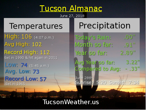
Lots of storm action in Cochise County yesterday with some of the activity as close as the Pima County line. Drier air has moved in as evidenced by the refreshingly cool morning in progress. Looks like this morning’s low will end up being 75 (average is 73). Dry air will stick with us most of next week with moisture getting closer and closer to the metro. By Friday it looks like we will get in on some of the action! Until then, not too hot by early July standards with highs pretty close to the average of 102. Thanx to Bud, Monsoon 2018 has officially registered .91″ of rain in June. Can’t wait to see what July will bring! Stay tuned.

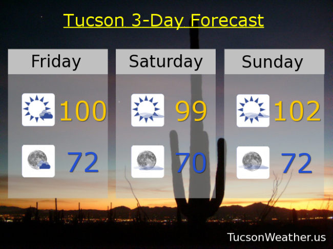
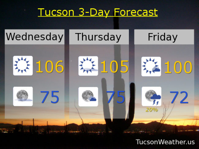
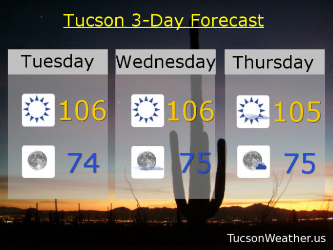
Sunny today with a high near 100. Clear tonight with a low in the upper 60s. 101ish tomorrow. 103 Monday. 102 Tuesday and for the 4th. 103 Thursday. Chance for storms Friday 103.

Forecast for Friday, June 29, 2018

It’s Friiidaaay!!!

That’s the good news. The bad news is thunderstorm chances have been removed from the forecast until after the 4th of July. Despite a great surge of moisture last night from storms in Mexico (and a surge of dust with it), A SW flow will develop over southern Arizona thanx to a system to our NW. That should remove enough moisture to keep storms from forming around the Metro. I know. I’m not happy about it either. Still a chance for a few thunderstorms over the Catalina’s and Rincons, so they’ll be close. Also, Cochise County could see some storms again this afternoon/evening. It’s humid this morning with a dew point temperature in the upper 50s to near 60. Look for some drying by this afternoon and a cooler high near 100.

Mostly clear skies tonight with a low in the low 70s.

Sunny tomorrow near 99ish. 102 Sunday. 105 Monday. 103 Tuesday. 104 for the 4th. Slight chance for storms Thursday 107! The waiting is almost over… Hang in there.

Forecast for Thursday, June 28, 2018

Friday Eve! Makes the weekend seem closer 😎

106 again yesterday. What is that? Three days in a row now? A welcome change to the weather pattern is on the doorstep that will bring moisture up from Mexico starting as early as today. We could see a few storms near the international border this afternoon, but we will still be kinda hot in the Metro with a high near 105. 102 is average for this time of year so… A few more clouds for possible sunset enhancement, so keep your LG, iPhone, Pixel, Galaxy S whatever handy!

Storm chances move into Tucson by late Friday afternoon/evening for a few storms possible, hopefully near you! Cooler too with a high near 101.

Just a slight chance for storms Saturday afternoon/evening near 99ish.

Sunny Sunday 100. 103 Monday. 104 Tuesday. Slight chance for 4th of July storms 104.

Forecast for Wednesday, June 27, 2018

Nice morning for coffee on the deck. Mid 70s currently after a hot day yesterday with a high of 106. We do that again today with tons of sunshine. 105 tomorrow as high pressure is flexing it’s metaphorical muscles. High pressure moves east by Friday opening the door for moisture to move in from the south. A few storms around Friday evening into Saturday, hopefully one near you! It’ll be cooler Friday and Saturday too with highs near 100 & 98 respectively. Sunny Sunday 100ish. 104 Monday and Tuesday.  We are slowly getting there! Let’s go Monsoon 2018.

Forecast for Tuesday, June 26, 2018

103 yesterday just 1 degree above average for this time of year. Today’s record high of 117 set in 1990 is also the all time record high for Tucson. Thankfully that is safe, but it will still be hot this afternoon. High pressure building in over SE Arizona will have us near 106 today and tomorrow. 105 Thursday. As the high moves east that should open the door for moisture to move north and we actually have a 20% chance for thunderstorms Friday, Friday night and Saturday, hopefully near you! Highs Friday and Saturday 101 and 99 respectively. Sunny on Sunday 101. 104 Monday. Let’s go Monsoon 2018! You got this.