Tag Archives: Flash Flood Watch

Forecast for Thursday, July 2, 2020

Well that escalated quickly! A FLASH FLOOD WATCH this afternoon?! Yep. But it’s not quite the good news that it sounds like. I mean, it IS good news that scattered showers and storms are in the forecast! However, it is because of the Bighorn Fire that the National Weather Service has issued the watch. The burn scars could mean runoff issues from any downpours that pour on the mountain. So yay! scattered showers and storms! But… the fire and its aftermath will likely continue to be an issue as we enter Monsoon 2020…

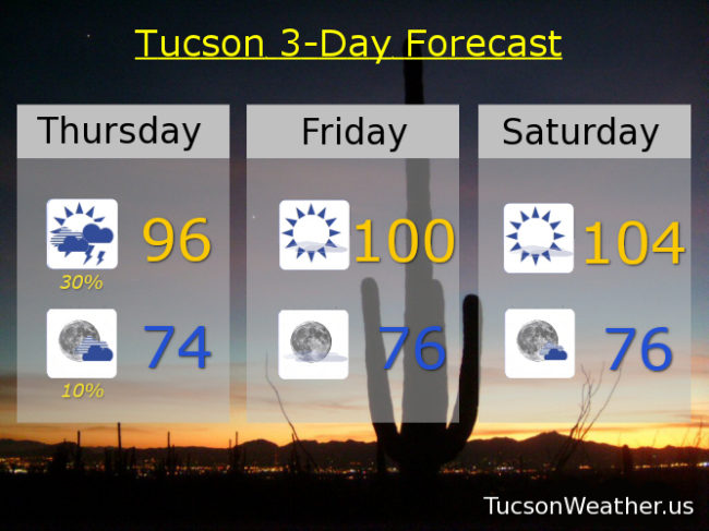
Increased moisture means scattered showers and storms this afternoon with partly sunny skies. Mid 90s this afternoon along with a FLASH FLOOD WATCH from 1:00 until 8:00. Showers ending tonight mid 70s. Mostly sunny tomorrow 100ish. 104 for the 4th. 105 Sunday. 104 Monday. 10% chance for storms Tuesday 103. Mostly sunny Wednesday 104. Enjoy!

Forecast for Friday, November 29, 2019

Here comes a cold front! If it hits you like it did us here in Phoenix at 4:00 a.m., look out! I swear a couple of trees were gonna blow down! They didn’t, but wow, that was exciting! Good thing standing in long lines at 4:00 a.m. for Black Friday isn’t a thing anymore. (is it?) Either way, strong winds ahead of the front and as it passes this morning. Still expecting valley rain and massive mountain snow today. .5″ to 1.5″ inches of rain possible. 1 to 2 feet of snow above 7,000 feet (I’m looking at you Summerhaven) and 3 feet or so at Ski Valley. Exciting times!

FLASH FLOOD WATCH in effect until 5:00 this evening and a WIND ADVISORY until 2:00 this afternoon, so be advised, it’s windy. Wind gusts over 30 mph with a 100% chance of rain. Winnie the Pooh and the Blustery Day would be proud. (silly ol’ bear) Today’s high in the upper 50s.

Clearing skies by tonight if not sooner with perhaps a lingering shower and a low in the upper 30s.

Cool tomorrow after that chilly start (mmm chili) and a high in the upper 50s.

Sunny Sunday upper 60s. Low 70s Monday. Partly sunny Tuesday low 70s. A 20% chance for showers Wednesday near 70ish. 30% Thursday upper 60s. Enjoy!

Forecast for Thursday, November 21, 2019

It’s Friday Eve! (makes the weekend seem closer)

Record rainfall yesterday! (see previous post) Already about a half inch of rain since midnight with showers still lurking this morning. (see future post) This Winter is off to an amazing start and it’s not even Winter yet 🙂

The FLASH FLOOD WATCH expires at 8:00 this morning as our storm will be winding down tonight. The WINTER STORM WARNING for Summerhaven is in effect until 11:00 tonight. Nearly a foot to a foot and a half of snow possible in them there hills! Meanwhile back at the ranch, rain in the forecast today as the main low currently located in NW AZ moves through along with a cold front. A thunderstorm is possible too, hopefully near you! Yes, it’ll be chilly (mmm chili) with a high only in the upper 50s!

Shower chances hangin’ in there before midnight tonight and then just mostly cloudy and cool with a low in the mid 40s.

Sunshine returns tomorrow with a bit of a warming trend through the weekend. Low 60s tomorrow. Upper 60s to near 70 Saturday. Low 70s Sunday and Monday. Upper 60s Tuesday. Another storm possibly moving our way in time for the Thanksgiving weekend! A 20% chance for rain Wednesday mid 60s. Stay tuned!

Forecast for Wednesday, September 19, 2018

A record amount of moisture for a September 19th in place. Add some energy as a trough approacheth from the west and you have a recipe for numerous showers and storms with locally heavy rainfall. So. The National Weather Service has issued a FLASH FLOOD WATCH starting at 11:00 this morning in effect until 11:00 tonight. The forecast calls for .75″ – 2.50″ of rain! Hopefully that comes true (hopefully near you) and Monsoon 2018 will leave us with lasting memories. With the clouds and expected rain today’s forecast high is only 85. Showers and storms may last into the overnight hours with a low tonight in the upper 60s. Viva Monsoon 2018!

We get back to a westerly flow starting tomorrow and we start a drying trend. Scattered storms still hanging in there for tomorrow with a high near 90ish. Just a 10% chance Friday low 90s. Sunny mid 90s Saturday through Tuesday.

Forecast for Friday, August 24, 2018

It’s Friiidaaay!!!

A FLASH FLOOD WATCH is in effect today from 11:00 this morning until Midnight tonight. So. Much. Moisture. Plus an inverted trough AND another upper low heading our way all adding up to what should be numerous storms today. Some storms will be capable of dropping 1-2 inches of rain (or more) in a short amount of time. We’ll see. We make fun of the jinx that often happens when the Weather Service issues a Flash Flood Watch. Yesterday was off to a promising start and then storms evaporated in the Metro as soon as the watch was issued! Still, flooding occurred in Nogales, near Sierra Vista, Douglas and more, so they weren’t wrong. Will Tucson see flooding rains today/tonight? It looks like a distinct possibility, so just remember to enjoy Monsoon 2018 responsibly. Don’t drive through running water and you should be good! I know you know that, but it’s worth mentioning because we at Tucson Weather care about you! ❤️ Viva Monsoon 2018!

70% chance for storms today, some with heavy rainfall, and a high of only 90! 70 by tomorrow morning with a 50% chance for storms tonight. Again some with heavy rain possible.

Moisture and instability will be with us into tomorrow so a 30% chance for storms and a high near 93.

We start to dry out Sunday as we will be in a more westerly flow. A 20% chance for storms, but a better chance to our east. Sunday’s high in the mid 90s.

Drying out more Monday with a 10% chance upper 90s. Mostly sunny Tuesday and Wednesday near 100ish. Sunny Thursday 101.