Monthly Archives: April 2018

Forecast for Monday, April 30, 2018

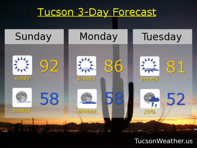
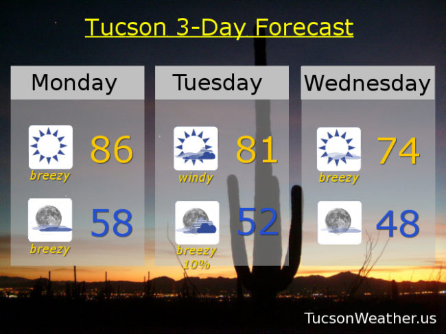
Another day. Another RED FLAG WARNING. Yesterday’s peak wind gust at the airport was 36 mph out of the west. We should experience similar conditions today albeit a little cooler and not quite as windy. Winds becoming WSWesterly 15-20 mph gusting to around 30 with a high in the mid 80s.

Our storm approacheth even closer tomorrow for a windier day with more clouds and cooler too. A FIRE WEATHER WATCH for tomorrow for SW winds 20-25 mph gusting to near 40 and a high in the low 80s.

A slight chance for showers or a thunderstorm Tuesday night! Snow levels may even drop below 7,000 feet. Breezy too with SW winds gusting to near 30 and relaxing after midnight and a low in the low 50s.

The storm clears out exit stage east Wednesday with some lingering breezes gusting to around 25 and a high in the mid 70s.

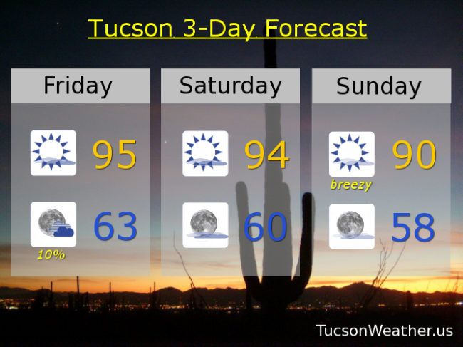
Fast warm up through the weekend. Sunny upper 70s Thursday. Upper 80s Friday. Mid 90s Saturday. Upper 90s Sunday. Enjoy and Good Luck!

Forecast for Sunday, April 29, 2018

There’s a lot of wind in this forecast as a strong system to our north approacheth from the Pacific Northwest. So much so that the National Weather Service has issued a RED FLAG WARNING starting at Noon today until 7:00 tonight. Not quite as windy tomorrow but a FIRE WEATHER WATCH has been issued from Noon tomorrow until 7:00 p.m. Please be careful setting stuff on fire lest you burn it all down! By Tuesday a secondary low travels further south around the backside of the first low. Looks like we might get into a chance for thunderstorms and/or showers Tuesday night situation! Maybe even a little snow above 6,500 feet!!! Turning much cooler with highs Wednesday and Thursday in the 70s. Looks like April will end with no rain for the month. Zero. Zip. Nada. May may be a different story!

Sunny and windy today with areas of blowing dust and human misery. Winds becoming SW this afternoon 15-25 mph gusting to near 40 and a high in the low 90s.

Breezy tonight with SW winds 10-20 mph gusting to near 30 relaxing after midnight and a low in the upper 50s.

Sunny and breezy tomorrow with WSW winds 10-20 mph gusting to near 30 and a high in the mid 80s.

Partly sunny and breezy Tuesday with SW winds 15-25 mph gusting to near 35 and a high in the low 80s.

Chance for thunderstorms Tuesday evening and a chance for showers overnight with a low in the low 50s.

Mostly sunny Wednesday 75ish. Upper 70s Thursday. Upper 80s Friday. Mid 90s Saturday.

Forecast for Saturday, April 28, 2018

It happened! It actually rained a few drops on me last evening when I was on my deck enjoying the sunset. Not enough to wet the deck or anything, but what my Dad calls a two inch rain; the raindrops where two inches apart! No rain chances in the foreseeable future. 96 was yesterday’s high and we should be in the mid 90s again today for the fifth day in a row or something. Then. It’s baaaack. The wind returns tomorrow and stays through Tuesday. Ugh! A couple of storms missing us to the north (you know the routine) will kick up the winds with areas of blowing dust and a high fire danger. Cooler temperatures too, so there’s that. Average high this time of year is 86 and we will be much cooler than that Tuesday, Wednesday, Thursday. Sometimes it’s good to be below average! (don’t ask me how I know that) Enjoy!

Sunny today with a high near 94ish.

Clear skies tonight with a low in the low 60s.

Sunny and breezy tomorrow with winds becoming SW in the afternoon 15-25 mph gusting over 30. Tomorrow’s high in the low 90s.

Sunny and breezy Monday with WSW winds gusting to near 30 and a high in the mid 80s.

Partly sunny breezy Tuesday low 80s. Sunny Wednesday upper 70s! Near 80 Thursday. Upper 80s Friday.

Forecast for Friday, April 27, 2018

95 again yesterday for the third day in a row. Not bad really. A little warm, but it hasn’t been bothering me. We’ll be right there again today, but with some changes. A trough moving through from the west combined with a bit more moisture will give us a slight chance for a storm or two this evening. The best chance will be near the mountains. It’s still too dry at the surface, so if we do manage a storm or two expect more wind and dry lightning than rain. That could be fire dangerous! Still, it’ll be nice to see some build ups as long as lightning doesn’t go pyro on us. Late in the weekend we transition to cooler and breezy weather as a couple of storms miss us to the north. Still kinda Spring!

Mostly sunny today with a SW breeze this afternoon 5-15 mph and gusty with a high near 95ish.

Slight chance for an isolated storm or two this evening. Gusty winds near showers. Becoming mostly clear overnight with a low in the low 60s.

Sunny tomorrow with a high in the mid 90s. Breezy Sunday with SW winds gusting over 30 and a high near 90. Breezy Monday mid 80s. Breezy Tuesday low 80s. Upper 70s Wednesday. Low 80s Thursday.

Forecast for Thursday, April 26, 2018

Our warm late April days continue into the weekend with highs in the mid to low 90s for highs. That’s about 10 – 8 degrees above average for this time of year. High cloudiness from time to time for possible sunrise and sunset enhancement. The bad news is the National Weather Service has dropped our slight chance for storms for Friday and Saturday. Even worse, it looks like our Spring winds will return Sunday through Tuesday. Cooler temperatures though as we go, so there’s that. Hang in there!

Mostly sunny today with a high near 95ish. Mid 90s tomorrow. Low 90s Saturday. Sunny and breezy Sunday near 90. Breezy Monday upper 80s. Breezy Tuesday mid 80s. Upper 70s Wednesday.