Monthly Archives: December 2018

Forecast for Monday, December 31, 2018

Our winter storm approacheth! Already some winds kicking up out there. It will be a “breezy” day with south winds gusting over 30 mph. Increasing clouds with a slight chance for showers this afternoon even. Rain begins in earnest (and Tucson too) tonight with the National Weather Service giving us a 100% chance for rain! 💯 Rain mixing with or changing to snow New Year’s morning with a WINTER WEATHER ADVISORY in effect above 3,500 feet from 5:00 p.m. tonight until 5:00 p.m. tomorrow night. I’m looking at you Catalina, Vail, and Corona de Tucson! Maybe an inch or so of snow for y’all! What a great way to start the year if we could manage snow showers in and around Tucson tomorrow morning! Meanwhile in the mountains it’s a WINTER STORM WARNING from 2:00 this afternoon until 5:00 p.m. tomorrow. Summerhaven expecting 1 to 2 feet of snow!!!

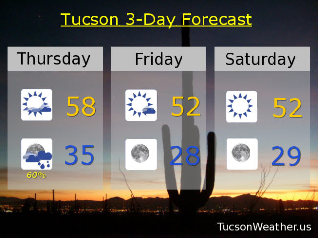
All of this excitement is followed up by a HARD FREEZE WARNING for the Metro starting tomorrow night at 10:00 p..m. until 9:00 a.m. Wednesday morning. Mid 20s expected! Hopefully no more flies on my hikes. For those of you sick of the cold, take heart. Warming up to near average (mid 60s) by Friday and Saturday. Another Storm in here by the end of the weekend but it looks like snow levels high enough to maybe even melt some mountain snow. Stay tuned!

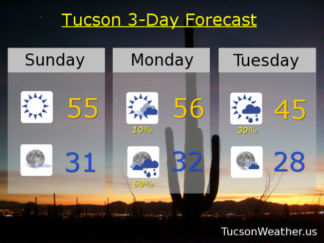
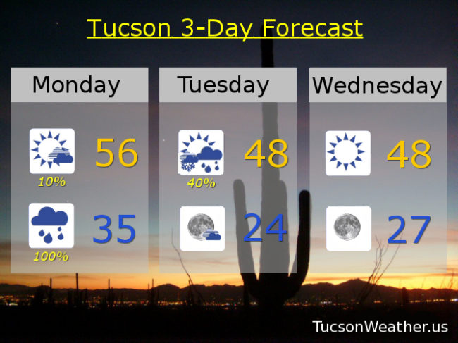
Increasing clouds and breezy today with south winds 15-25 mph gusting to near 35. 10% chance for showers this afternoon and a high in the mid 50s. 100% chance for showers tonight with snow possible above 3,500 feet and a low in the mid 30s. Scattered rain and snow showers tomorrow morning followed by scattered rain showers with decreasing clouds late and a high in the upper 40s. Mostly clear Tuesday night/Wednesday morning with a low near 24ish! Sunny Wednesday upper 40s. Upper 50s Thursday. Mid 60s Friday and Saturday. 40% Sunday upper 50s. Enjoy!

Forecast for Sunday, December 30, 2018

Looks like 28 for our official low this morning!

With all this weather excitement I find myself springing out of bed and racing to my comput… wait. Scratch that. Racing to my kitchen to make coffee and THEN to my computer to see what the weather updates are saying. The New Year’s Eve/New Year’s Day storm is on track. BUT (there’s always a but) there are differences between the computer models. Enough to leave a bit of uncertainty (which is why we love weather!). I’ll just steal from the National Weather Service Forecast Discussion from this morning at 4:25 (your taxpayer money at work) to help sort “things” out. Basically they are splitting the difference between two models. One that is trending a bit stronger and wetter. The other not as much of both. These snowfall amounts and levels are a ballpark compromise and you can imagine how a small difference either way can make a big difference in the actual weather we get to experience. My hat (cap) is off to them. They really do a great job!

Prime time will be New Year’s Eve into New Year’s Day. Snow levels and amounts tentatively look like this: 3,000 – 4,000 feet: dusting to an inch. 4,000 – 5,000 feet: 1 to 3 inches. 5,000 – 7,000 feet: 3 to 5 inches. Above 7,000 feet: 7 to 14 inches. Expect the National Weather Service to issue winter headlines by this afternoon as more data comes available later today.

After the storm 2019 will be off to a cold start! Lows back in the 20s Wednesday morning and near 30ish Thursday morning. There will be a warming trend with highs actually right around average by Friday and Saturday! Beyond the 7 day forecast looks interesting with another storm or two perhaps in our early January future. They look much warmer but it’s a ways out. Stay tuned!

Sunny today with a high in the mid 50s. Clear tonight freezing. 10% chance tomorrow mid 50s. 60% chance New Year’s Eve near freezing. 30% New Year’s Day mid 40s. Sunny Wednesday near 50ish. Upper 50s Thursday. Mid 60s Friday and Saturday. Enjoy!

Forecast for Saturday, December 29, 2018

The HARD FREEZE WARNING that is set to expire at 9:00 this morning is coming true with a low so far at the airport of 29 degrees. My plants are inside from deck watching TV with me this morning. (just kidding. I don’t have the TV on…) It’ll be another chilly day (mmm chili) with a FREEZE WARNING still in place for tonight from midnight until 9:00 a.m. Sunday. Be warned. It’s gonna be freezing! All eyes are on our next storm and the computer models are starting to agree. Good chance for rain and mountain snow New Year’s Eve and New Year’s Morning! The big question is how low will the snow level go? The National Weather Service is likely to issue Winter highlights, as they call them. That just means we are likely to see a Winter Storm Watch above say 5,000 feet and maybe a Winter Weather Advisory above maybe 3,500 feet. You’ll know when it’s official because I’ll put those in ALL CAPS. Anyway, we could see snow showers in the Metro. Not expecting major accumulations in town or anything, but it could actually snow! Stay tuned and stuff!

Sunny today with a high near 50ish. Mostly clear skies tonight with a low near 30. Sunny low 50s tomorrow. Mostly sunny Monday mid 50s. 40% chance for showers New Year’s Eve mid 30s. 20% chance New Year’s Day upper 40s. Sunny Wednesday low 50s. Low 60s Thursday. Upper 60s Friday. Enjoy!

Forecast for Friday, December 28, 2018

It just gets interestinger and interestinger! Last night’s storm was amazing. Rain started about 4:00 yesterday afternoon and didn’t let up until about 9:00! Then off and on showers overnight with sticking snow repoerted in Corona de Tucson (thank you Tina!) and also from Vail east as snow levels did indeed crash down to 3,500 feet. The airport picking up a third of an inch (.34″) of rain before midnight. Decreasing clouds today as our storm exits stage east. It’ll be cold with the FREEZE WARNING still a go from midnight tonight until 9:00 a.m. Saturday morning and then again midnight until 9:00 a.m. Sunday. However. Saturday night/Sunday morning is looking interestinger. Our storm still lingering to our east could trigger some snow showers perhaps as far west as Tucson? No showers yet included in the Metro’s official forecast but a slight chance has been added for Summerhaven. Stay tuned there. THEN another storm approacheth for New Year’s Eve into New Year’s Day that originally looked like it was going to miss us to the east may actually give us a chance for rain/snow? The official forecast keeps us dry right now. Again. Stay tuned there as we have a lot to sort out yet in 2018!

Decreasing clouds today but still a chance for a lingering rain or snow shower before 8 a.m. and a high this afternoon near 50ish. Mostly clear tonight with a low in the upper 20s. Sunny tomorrow near 50ish. Upper 20s Sunday morning. Sunny Sunday low 50s. Mostly sunny Monday mid 50s. Sunny New Year’s Day low 50s. Mid 50s Wednesday. Mid 60s Thursday.

Forecast for Thursday, December 27, 2018

We are going from chilly (mmm chili) to downright COLD. Our next Winter storm approacheth and it promises to bring rain and mountain snow tonight. WINTER WEATHER ADVISORY above 5,000 feet has been issued starting at 8:00 tonight until 8:00 tomorrow morning. The official forecast for Sumerhaven is calling for 5 to 9 inches of snow possible tonight! Meanwhile back in the Metro the question is will we snow in the morning? The answer is… I really don’t know. It’s going to be close! Snow levels falling to near 3,000 feet by daybreak. So. Will there still be showers around at daybreak or will the storm be done by then. If there are showers around we might have some snow falling tomorrow morning in and around town. I’ll be up early looking just in case!!!

OK. So then the storm is out of here tomorrow with COLD air in its wake. FREEZE WATCH is in effect for the Metro Saturday morning midnight to 9:00 a.m. and Sunday morning Midnight to 9:00 a.m. Pets, People, Pipes, Plants. Oh, and, consider letting the teenagers sleep in the house. Staying on the cool side through New Years Day and then warming slight by mid next week. Be cool! But stay warm.

Increasing clouds today with a high in the upper 50s. Showers likely tonight after midnight with a low in the mid 30s. Sunny tomorrow low 50s. Mostly clear Saturday morning upper 20s. Sunny Saturday low 50s. Clear skies Sunday morning upper 20s. Sunny Sunday low 50s. Mostly clear Monday morning near freezing. Sunny Monday upper 50s. Near 30ish New Years morning mid 50s by afternoon. Near 30ish Wednesday morning low 60s by afternoon.