Monthly Archives: May 2018

Forecast for Thursday, May 31, 2018

It’s Friday Eve! Makes the weekend seem closer 🙂

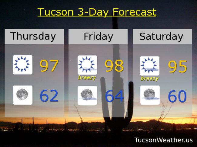
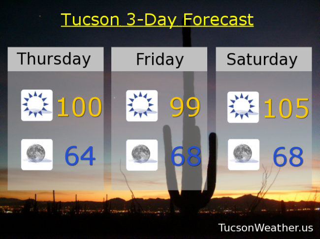
Yesterday’s expected high was 100. In the words of Maxwell Smart, we “missed it by that much”. We did hit 99 which was his beautiful agent girlfriend/wife, so there’s that. Average for this time of year is 97, so not far off. We’ll make another run at 100 today with some SW breezes in the afternoon and a few clouds perhaps for sunset enhancement, but mostly it will be sunshine and warm.

Clear skies tonight with a low in the mid 60s. So nice in the mornings.

Sunny tomorrow 99ish. High pressure building in for the weekend and hot. 105 Saturday. A record tying 107 Sunday (if it comes exactly true). 105 Monday. 103 Tuesday.

“Things” could get interesting by Wednesday. As high pressure moves into New Mexico there will be an increase in moisture in our neck of the woods (er, Saguaro forest?). The computer models are hinting at a disturbance in the force riding northward out of Mexico on the western edge of the high that might trigger thunderstorms! Don’t get too excited yet. It’s still pretty far out in forecast terms and the National Weather Service hasn’t put the possibility in it’s official forecast yet. Just something to keep an eye on and of course we’ll keep you posted here. I’ve been hearing Cicadas since last week! Maybe it means something. Stay tuned and be cool.

Forecast for Wednesday, May 30, 2018

Real deal heat coming this weekend. The big hurt highs arrive just in time for June. (it happens) A few thin high clouds around through Friday for possible sunrise and sunset enhancement, so keep those Nikon’s and Canon’s at the ready! Who am I kidding. It’s more like iPhones and Androids, but I digress. The big story is the heat this weekend. Strong high pressure building in, so stay hydrated lest you burst into flames!

Sunny today with a SW breeze this afternoon 5-15 mph ish and a high near 100.

Mostly clear tonight with a low in the mid 60s.

Sunny tomorrow and Friday near 99. (99. I’ve been waiting so long. Oh 99, where did we go wrong? 99. I love you…) Sunny Saturday near 104. 108 Sunday?!!! Yikes! 104 Monday. 102 Tuesday. Be cool!

Forecast for Thursday, May 24, 2018

Sunshine. On my shoulders makes me happy. Sunshine. In my eyes can make me blind… Thank you John Denver! It’s Friday Eve! Makes the weekend seem closer. Warming up today and tomorrow as high pressure noses in. Upper 90s both days. The breezes return tomorrow and get stronger on Saturday. The official National Weather Service forecast only has our winds 5-15 mph tomorrow and about the same Saturday, but their forecast discussion says it’ll be breezy/windy. I’ve seen them do this before and the forecast discussion usually wins out, so I’ll boost those number below (see below) FTW. Slight cooling Sunday and then near 100 after Memorial Day. Enjoy!

Sunny today with a high in the upper 90s.

Clear skies tonight with a low in the low 60s.

Sunny and breezy tomorrow with SW winds in the afternoon 5-15 mph and gusting higher and a high in the upper 90s. Breezier Saturday with SW winds 10-20 mph and gusting higher and a high in the mid 90s. Mid 90s Sunday. Upper 90s Memorial Day. Near 100 Tuesday. 101ish Wednesday.