
Monthly Archives: May 2018
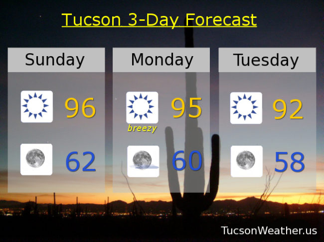
Forecast for Wednesday, May 23, 2018
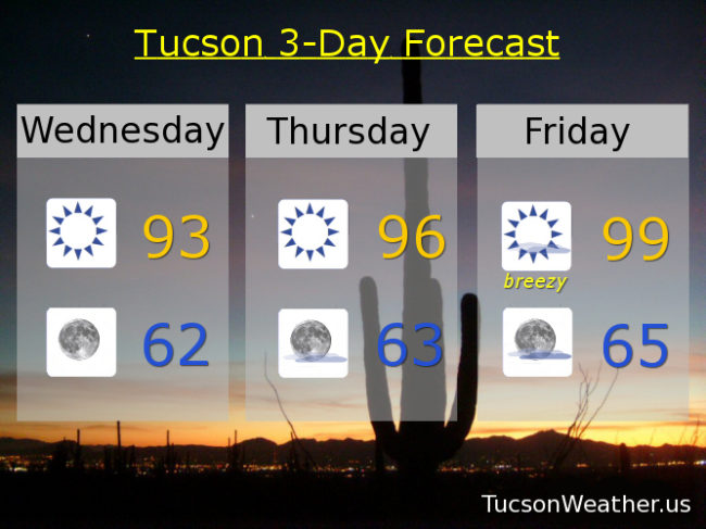
91 yesterday. 3 degrees below average for this time of year! 64 for the low was 2 degrees above. Average all that and it was a pretty, average, day! Pretty and average again today with a high of 93ish after a refreshingly cool low of 60 this morning. Warming up the next couple of days as high pressure builds in. Followed by a storm missing us to the north that will kick up the breezes, especially Friday and Saturday, and bring slight cooling. Staying dry unfortunately, but hey, make hay while the sun shines!
Sunny today with a SW breeze 5-15 mph this afternoon and a high near 93. (see above)
Clear skies tonight with a low in the low 60s.
Sunny tomorrow mid 90s. Breezy Friday and Saturday upper 90s. Mid 90s Sunday. Upper 90s Memorial Day and Tuesday.
Almanac for Tuesday, May 22, 2018

Forecast for Tuesday, May 22, 2018
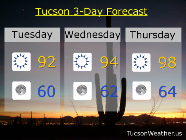
Another breezy day as a storm system is sitting over southern Nevada. As it weakens and moves into the northern Rockies our breezy conditions will improve. Temperaturewise a couple of days near average for this time of year! Then high pressure builds in and we’ll warm up to near 100 Friday. Another system misses us to the north this weekend for a return of the wind. “Cooling” into the upper 90s for the Memorial Day weekend. Considering June is only a week and a half away, not bad at all!
Sunny and breezy today with winds this afternoon out of the SW 10-20 mph and gusty and a high in the low 90s.
Breezes relax tonight with clear skies and a low near 60.
Sunny tomorrow with a lingering SW breeze 5-15 mph and gusty with a high in the mid 90s. Sunny Thursday upper 90s. Near 100 Friday. Breezy this weekend with highs in the upper 90s.
Almanac for Monday, May 21, 2018
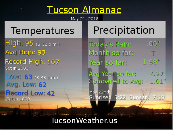
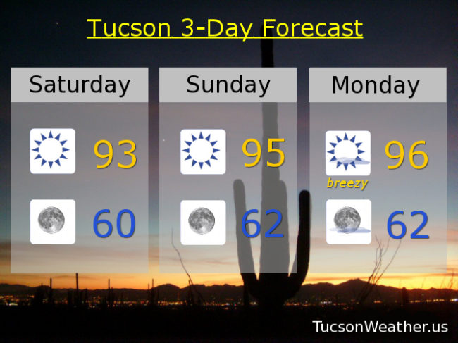
Forecast for Monday, May 21, 2018
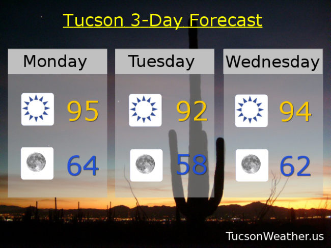
A bit breezy today as a storm system moves from California into the Great Basin. That will knock our temperatures down to exactly normal for this time of year tomorrow for a somewhat brief cool down. High pressure building in with highs back in the triple digits by Friday through the weekend. Enjoy!
Sunny today with a SW breeze this afternoon 10-20 mph and gusty. High near 95ish.
Clear skies tonight with a low in the mid 60s.
Sunny tomorrow with SW breezes 10-20 mph and a high in the low 90s.
Mid 90s Wednesday. Upper 90s Thursday. 100 Friday. 103 Saturday. 102 Sunday.
Almanac for Sunday, May 20, 2018

Forecast for Sunday, May 20, 2018
Yesterday was exactly average for this time of year! 93 for the high after a low of 61. Very nice. Warming up today a bit before some winds hit us tomorrow with a brief cool down Tuesday. Triple digits return By Friday into next weekend. How else are you gonna warm up that pool?
Sunny today with a high in the mid 90s.
Clear tonight with a low in the low 60s.
Windy tomorrow as a storm moves through from California. No moisture to speak of for much needed rain, but the winds will be out of the SW 15-25 mph gusting over 35. High near 95ish.
Cooling into the low 90s Tuesday (with some lingering winds) behind the exiting system. Mid 90s Wednesday. Upper 90s Thursday. Near 100 Friday. 101 Saturday. Enjoy!
Almanac for Saturday, May 19, 2018

Forecast for Saturday, May 19, 2018
Yesterday was almost exactly normal for this time of year. A high of 92 after a low of 60 compared to seasonal averages of 92 and 61. Well done Tucson. A bit warmer today with a bit of a westerly breeze. A high near 93 after another average low this morning of 61ish. Refreshing!
Mid 90s tomorrow and Monday. However. A low pressure system approacheth on Monday kicking up the winds once again. SW breezes 10-20 mph and gusting higher. A chance for thunderstorms in the White Mountains, but we don’t live in the White Mountains, do we. So there’s that. Breezy on Tuesday too with a high in the mid 90s.
Mid 90s Wednesday. Upper 90s Thursday and Friday. Enjoy!