
Monthly Archives: May 2018
Forecast for Friday, May 18, 2018
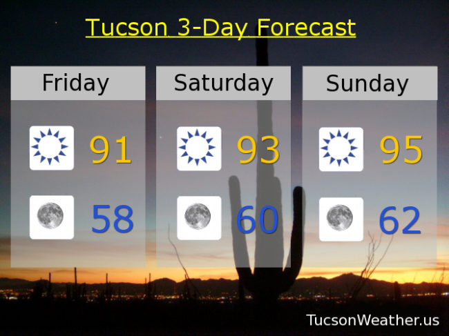
Who’s up for a couple of average days for mid May?! 92 is our average high for this time of year and 61 our average low. As you can see from the handy graphic above (we’d like to warn our viewers that this post contains graphics material) that we’ll be pretty close to those values. A bit of a south breeze today 5-10 mph and gusty, but not bad at all. Low 90s for highs today and tomorrow and refreshingly cool mornings in the upper 50s to near 60. Sunday looks nice with a high in the mid 90s. Another breeze maker to start next week. Call it “breezy” on Monday with a high in the upper 90s. Sunny mid 90s Tuesday, Wednesday and Thursday. Enjoy!
Almanac for Thursday, May 17, 2018

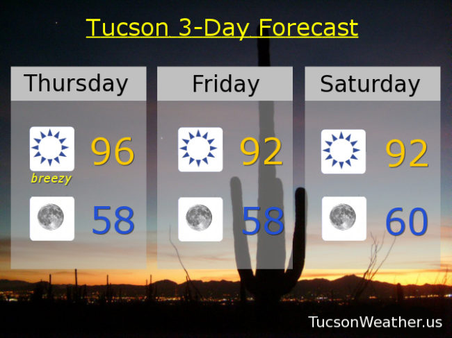
Forecast for Thursday, May 17, 2018
Shocker! A RED FLAG WARNING is in effect from 11:00 this morning until 7:00 tonight. The winds won’t be all that bad. WSW 10-20 mph and gusty, but it’s just so stinkin’ dry one cigarette butt out of the car and the whole place could go up. Remember. The world is not your ash tray. (of course you already knew that, it’s just me being PC) Meanwhile, temperatures will moderate somewhat. Down a couple of degrees today and right at seasonal norms tomorrow and Saturday. More wind early next week with an increase of moisture well to our east. I only mention it because it’s a good sign of things eventually to come! Eventually. Until then, take it breezy!
Sunny and breezy today with a high of 96ish.
Clear skies tonight with a low in the upper 50s. (nice!)
Sunny and a bit breezy tomorrow with WNW winds 5-15 mph and gusty and a high in the low 90s.
Sunny Saturday low 90s. Mid 90s Sunday. Breezy Monday and Tuesday mid 90s. Mid 90s Wednesday.
Almanac for Wednesday, May 16, 2018

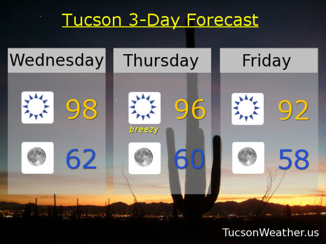
Forecast for Wednesday, May 16, 2018
All quiet on the southern Arizona front. In fact, no fronts, cold or otherwise. Just a cloudless sky with relentless Sun and kinda warm, but really not that bad. Another system will move into Nevada by Thursday kicking up our winds a bit and cooling us down some. Lingering breezes on Friday. The weekend looks great! Some warming and not as much wind. Another system to the north will likely kick up some breezes again early next week. Enjoy!
Sunny today with a high of 98ish.
Clear skies tonight low 60s.
Breezy tomorrow with WSW winds 10-20 mph and gusty and a high in the mid 90s. Low 90s Friday and Saturday. Mid 90s Sunday. Upper 90s Monday. Mid 90s Tuesday.
Almanac for Tuesday, May 15, 2018

Forecast for Tuesday, May 15, 2018
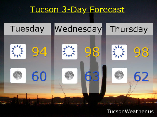
Yesterday’s high of 95 outperformed the forecast of 92. Still not a bad day for mid May. Yesterday’s breezes dying a bit more today but still a west breeze 5-15 mph and gusty with a high again in the mid 90s.
Refreshingly cool again tomorrow morning with a low near 60ish. (we got down to 59 this morning, so kinda like that)
A brief warm up Wednesday and Thursday with highs in the upper 90s.
Here come the winds again by Friday. Maybe not as windy as the last several days, but still on the gusty side as yet another system misses us to the north. Highs back into the low 90s Friday and Saturday. Warming back up Sunday mid 90s. Upper 90s Monday. Enjoy!
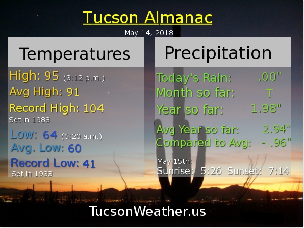
Almanac for Monday, May 14, 2018
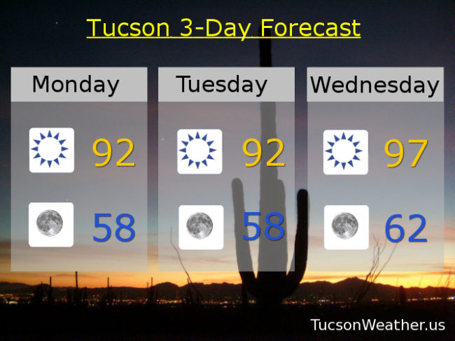
Forecast for Monday, May 14, 2018
Mother’s Day was nice. Yes, kinda windy but the high of 91 was exactly average and the low of 61 was just 1 degree above average. Pretty much what you would expect for this time of year. An upper level low is overstaying it’s welcome in northern Nevada. It’s weakening so our winds won’t be as strong today, but still some breezes to contend with. High pressure builds in for a warm up Wednesday and Thursday. Then it’s more wind and cooler by the end of the week into the beginning of the weekend as yet another low blows by to the north. Barely a cloud in the sky, but you can never rule out a few high clouds for possible sunrise and sunset enhancement. Enjoy!
Sunny and a bit breezy today with SW winds 10-20 mph gusting to around 25 and a high in the low 90s.
Clear skies tonight as the winds relax. Low in the upper 50s.
Sunny tomorrow low 90s. Upper 90s Wednesday. Mid 90s Thursday. Breezy low 90s Friday and Saturday. Mid 90s Sunday.