Monthly Archives: June 2020

Forecast for Tuesday, June 30, 2020

Only the beginning of what I want to feel forever. Only the beginning. Only just the start..

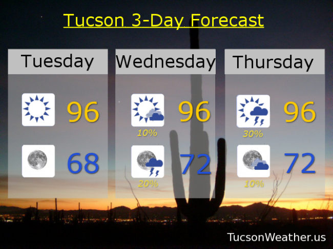
Monsoon 2020 ramping up! Moisture on the increase with storm chances going up as well. Could see some storms as early as tomorrow afternoon with a better chance Thursday! It’s only the beginning, but hopefully Monsoon 2020 won’t disappoint. Come on 2020, we could use a break!

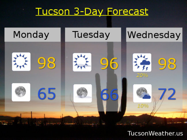
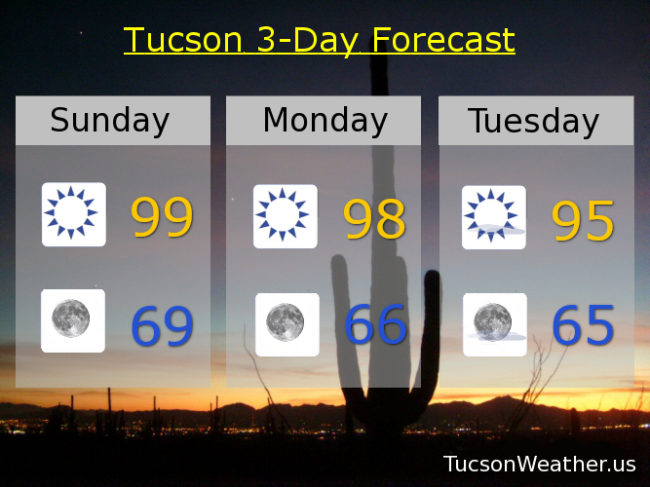
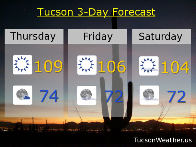
Sunny mid 90s today with a SW breeze 10-20 mph. Upper 60s tonight. A slight chance for a storm or three tomorrow afternoon and evening (hopefully near you) mid 90s. Scattered storms possible Thursday mid 90s. Mostly sunny Friday near 100ish. The 4th looks dry and kinda hot 104, but a chance for a storm or two in the evening. Slight chance for storms Sunday and Monday 106 and 105 respectively. Enjoy!

Forecast for Monday, June 29, 2020

Another blustery day in the thousand acre desert… A RED FLAG WARNING AND a WIND ADVISORY (so be advised… it’s gonna be windy) have been issued for today. Perhaps a bit repeatedly redundant, but it gets the idea across. Gusty winds and a high fire danger. If you smoke, keep your butt(s) in your car! Increasing moisture and a chance for storms Wednesday and a better chance Thursday. It’s getting to be that time of year! Kinda hot for the 4th… and the 5th.

Sunny and windy today with SW winds 20-30 mph gusting to 40 and a high in the upper 80s. Winds relax tonight especially after midnight mid 60s. Still breezy fo sheezy tomorrow with WSW winds 15-20 mph gusting to 30 with a high “only” in the mid 90s. A 20% chance for afternoon and evening storms Wednesday (hopefully near you) upper 90s. A 30% chance Thursday upper 90s. Mostly sunny Friday 101. 10% chance for storms on the 4th 104. 10% Sunday 105. Enjoy!

Forecast for Sunday, June 28, 2020

Another good news bad news kinda day. First the bad news.. A RED FLAG WARNING has been hoisted for today and tomorrow. Windy, warm, and dry equals a high fire danger. Seriously 2020. Just stop. There is good news… Cooler! Highs below 100 and lows in the upper then mid 60s! Overspray that VO5 and enjoy the rest of the weekend!

Sunny and windy today with a high of 99 (I’ve been waiting so long) SW winds 20-30 mph gusting to near 40. Winds relaxing after midnight tonight with a low in the upper 60s. Sunny and windy tomorrow upper 90s. SW winds 20-30 mph gusting over 40. Breezy fo Sneezy Tuesday with SW winds 10-20 mph gusting over 25 and a high in the mid 90s. Sunny Wednesday (but not Windsday) upper 90s. A slight chance for a storm maybe Thursday upper 90s. Sunny Friday 102 para tu. Mostly sunny for the 4th 105. Hang in there!

Forecast for Thursday, June 25, 2020

It’s Friday Eve! Makes the weekend seem closer…

Another scorcher today with a high of 109! Please, for the love of all that is right and good, stay hydrated lest you burst into flames! Seriously… we’ve had enough problems with fire already this month.

What goes up must come down.. 106 tomorrow. 104 Saturday. The winds of change Monday and even a slight chance for an isolated storm 100ish. Breezier Tuesday with a better chance for a storm or three upper 90s. Sunny 100ish Wednesday… Enjoy!

Forecast for Wednesday, June 24, 2020

Mike Mike Mike Mike Mike. What Day is it Mike? Another day starting with smoke and scorching heat… that’s what day it is!

“Not the Best” as my son says… Smoke from a not so distant fire hanging around again this morning. High pressure and not quite record heat at a time of year when we expect it to be hot. All the usual coping mechanisms apply. Hydrate, AC, become a snowbird… However, some like it hot! Some like it hot… This forecast is for you! Cooler temperatures this weekend into next week! If you like that this forecast is for you too…

Sunny today and a bit of a breeze. Becoming NW this afternoon 5-15 and a high of 108. Mostly clear tonight mid 70s. 109 tomorrow. 106 Friday. 104 Saturday. Breezy near 100ish Sunday! Breezy upper 90s Monday!! Upper 90s Tuesday too. Be Cool