
Monthly Archives: May 2017
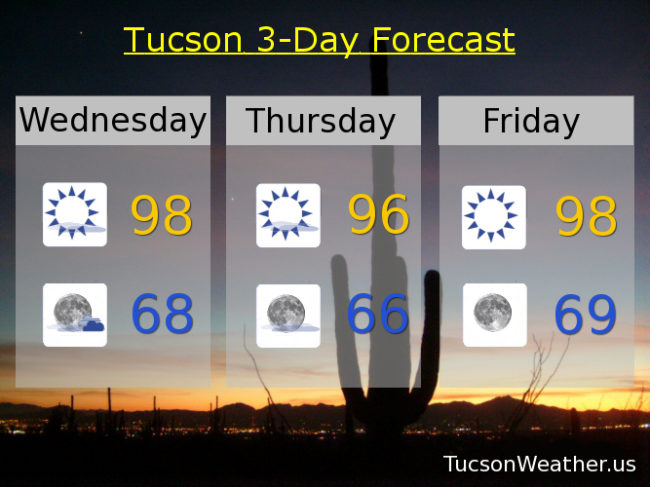
Forecast for Wednesday, May 31, 2017
I can’t afford a promotions department so I will have to toot my own horn (sounds painful). Yesterday I mentioned that if storms to our east formed a bit closer than expected we could see outflow winds in the afternoon/evening gusting to 40 mph. While they weren’t quite that we did get some fairly strong outflow breezes yesterday evening. Chances are this is the only place that gave you a heads up yesterday although I could be wrong about that. Anyway, thanx for reading, liking, sharing and considering becoming a Patreon. This is how I start my day 7 days a week for over the last several years!
Anyway… moving forward, our exiting low will give us lingering clouds into tomorrow for possible sunrise and sunset possibilities! Storms possible east of the Metro again this afternoon and evening. A bit cooler too to start June, but here comes the big hurt starting the weekend! Ah June. If we can survive you the rest of the Summer is gravy. (mmm gravy)
Mostly sunny today with a high in the upper 90s.
Partly cloudy tonight with a low in the upper 60s.
Mostly sunny tomorrow mid 90s. Upper 90s Friday. Near 103 Saturday. 104 Sunday. 103 Monday, Tuesday and Wednesday.
Almanac for Tuesday, May 30, 2017

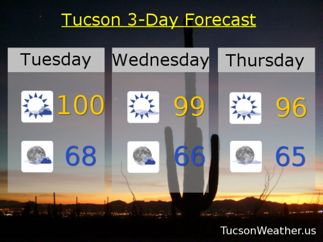
Forecast for Tuesday, May 30, 2017
Back to the salt mines for most of us. I have lots of watermelon left over from yesterday, so there’s that! More moisture and more clouds today as a weak low combined with an increase in moisture will give us a chance for storms south and east of Tucson. If those storms form close enough to us we may see some gusty outflow winds move through the metro later this afternoon/evening. It may not happen, but something to watch. More clouds as a result as well which will likely lead to sunset enhancement tonight. A little cooler the next couple of days behind the low. As you can imagine we will warm up by the first weekend of June, because, June! Back to the triple digits. Enjoy!
Mostly sunny today with a high near 100. SW winds 10-15 mph. Winds up to 40 mph IF thunderstorm outflow winds reach us by this evening.
Partly cloudy tonight with a low in the upper 60s.
Mostly sunny tomorrow upper 90s. Mid 90s Thursday. Upper 90s Friday and Saturday. Near 101 Sunday and Monday.
Almanac for Monday, May 29, 2017

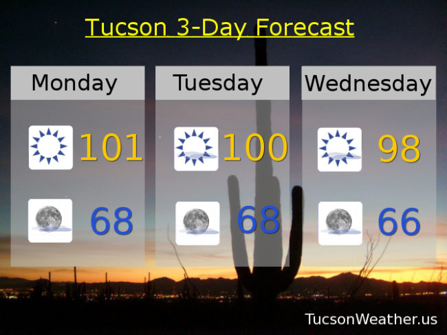
Forecast for Monday, May 29, 2017
Just beautiful on the deck this morning. A nice and cool start to a warm Memorial Day with nuthin’ but Sun. Moisture on the increase to our east, but it shouldn’t quite get to us this week. Just a few more clouds and slightly cooler as a weak system moves across the state Wednesday through Friday. Perhaps some sunrise and sunset enhancement possibilities! Heating up again by next weekend. Have an amazing Memorial Day as we remember the sacrifice of those who were willing to give all for our freedoms.
Sunny today near 101.
Mostly clear tonight near 68.
Mostly sunny tomorrow near 100. Upper 90s Wednesday. Mid 90s Thursday and Friday. Upper 90s Saturday. Near 101 Sunday.
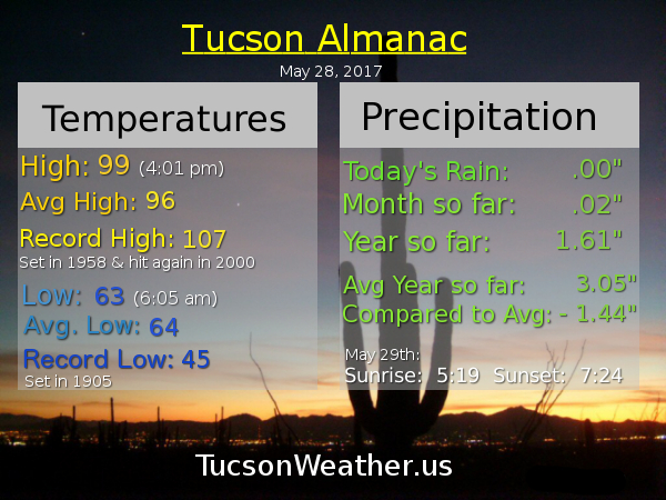
Almanac for Sunday, May 28, 2017
Forecast for Sunday, May 28, 2017
The triple digits return soon but only for a couple dayz. Then back near normal (96ish) by the end of next week as a bit more moisture sneaks in for a chance of a storm or two well to our east. Also a few more clouds for possible sunrise and sunset enhancement. Enjoy!
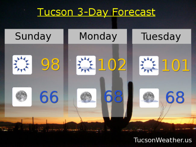
Sunny today with a high near 98.
Clear skies tonight with a low in the mid 60s.
Sunny tomorrow near 102. Near 101 Tuesday. Upper 90s Wednesday. Mid 90s Thursday and Friday. Upper 90s Saturday.
Almanac for Saturday, May 27, 2017

Forecast for Saturday, May 27. 2017
We are done with RED FLAG WARNINGS. (I never did see a red flag) Please continue to use common sense setting stuff on fire and stuff. It’s still really dry out there. Just lighter winds to fan the flames. High pressure building back in with tons of Sun and warmer temperatures this weekend. An increase in moisture may lead to a storm or two mainly to our east and in the higher terrain. (first time I’ve used the word “terrain” in a forecast!) It’ll also lead to a few more clouds for possible sunrise and sunset enhancement! Enjoy!
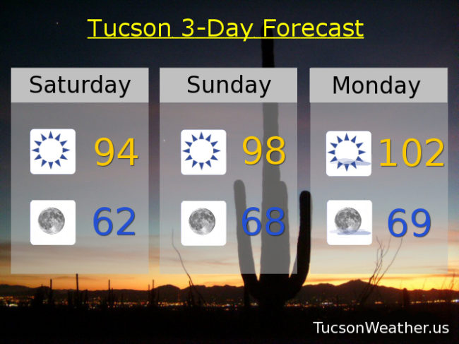
Sunny today with a high in the mid 90s.
Clear skies tonight with a low in the low 60s.
Sunny tomorrow upper 90s. Near 102 Memorial Day. Near 100 Tuesday. Mid 90s Wednesday, Thursday and Friday.