Monthly Archives: October 2018

Forecast for Wednesday, October 31, 2018

We are on the cool side of the cold front. We all get to be the cool kids for awhile! Maybe dress the young ones up as polar bears or Freddy Kruger with a warm jacket tonight. Effective AND practical! This light north breeze blowing into my apartment is so refreshing. It’s like that feeling you get when you trick or treat the house that is handing out the full size candy bars. We will be stuck in this pattern for the foreseeable future. High pressure to our west with a trough to our east. The resulting NW flow will keep us dry with a slight warming trend. Enjoy!

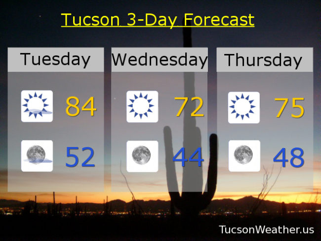
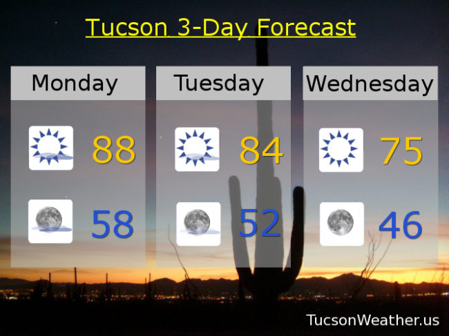
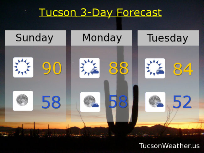
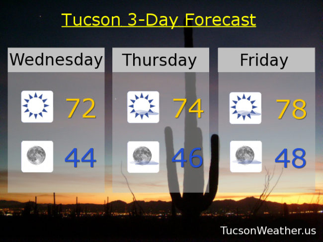
Sunny today with a high in the low 70s. Clear skies tonight and chilly (mmm chili) and a low in the mid 40s!

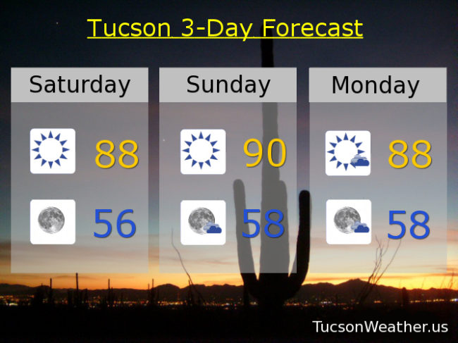
Mostly sunny mid 70s tomorrow. Upper 70s Friday. Near 80ish Saturday. Upper 70s Sunday. Near 80 Monday. Upper 70s Tuesday.

Forecast for Tuesday, October 30, 2018

Cold Front! Get your red hot cold fronts here! Why here comes one now. It should be blowing through through the day with SW winds 15-20 mph gusting to 30. As cold fronts are prone to do, colder air will be moving in behind it with morning lows quite chilly (mmm chili) especially Thursday and Friday mornings. Temperatures rebounding by the weekend with near average to a couple degrees above average highs for early November. Enjoy!

Mostly sunny and breezy today with a high in the mid 80s. Winds relaxing some tonight but still 5-15 with a low in the low 50s. Sunny low 70s tomorrow with temperatures in the 60s for ghouls and goblins out looking for candy. Mid 40s by Thursday morning! Mid 70s Thursday and upper 40s Friday morning. Upper 70s Friday. Near 80ish Saturday. Low 80s Sunday and Monday.

Forecast for Monday, October 29, 2018

I was hoping I wouldn’t have to break it to you. As you may know, Meteorologist Jeff Beamish has been telling us that if we could avoid a 90 degree day yesterday it would be the first October in 34 years without hitting 90 degrees. Unfortunately we topped out at 91. (sad trombone) Missed it by that much! High pressure is leaving us and a cooling trend will commence. A system missing us to the north will kick up some breezes and accelerate our cool down through mid week. Enjoy!

Mostly sunny today with a high in the upper 80s. Partly cloudy tonight upper 50s. Some high cloudiness for possible sunrise and sunset enhancement.

Mostly sunny Tuesday with WSW breezes 5-15 mph and gusty and a high in the mid 80s. Sunny Wednesday and Thursday mid 70s. Upper 70s Friday. Low 80s Saturday and Sunday.

Forecast for Sunday, October 28, 2018

High pressure over our heads bringing the heat. Well. relatively speaking. If the forecast comes true, today will be the one and only 90 degree day of this remarkable October. A storm heading for the Great Basin will miss us to the north the next couple of days. That will kick up our winds a bit and knock our temperatures down. No rain in sight. Then it’s a bit of a warming trend by next weekend. Enjoy!

Sunny today near 90ish. Mostly clear tonight upper 50s. Mostly sunny tomorrow upper 80s. Mid 80s Tuesday. Upper 70s Wednesday, Thursday, and Friday. Low 80s Saturday. Enjoy!