Monthly Archives: March 2018

Forecast for Saturday, March 31, 2018

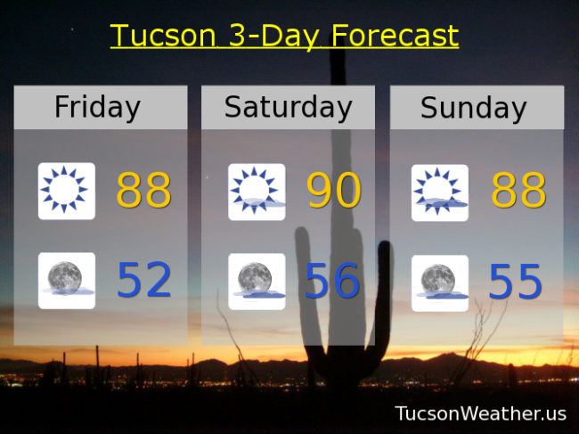
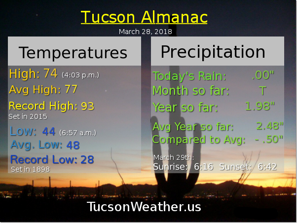
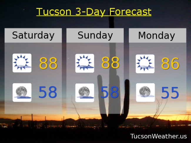
March is going out like it came in, like a lamb. High pressure has taken control with very warm temperatures for this time of year. Despite that, plenty of high clouds in our forecast this weekend for possible sunrise and sunset enhancement. Yesterday’s high of 85 was a couple three degrees “cooler” than forecast. Today’s expected high in the upper 80s to maybe 90 should (should) mean that the record of 91 will stay safe.

Mostly cloudy tonight with a low in the upper 50s.

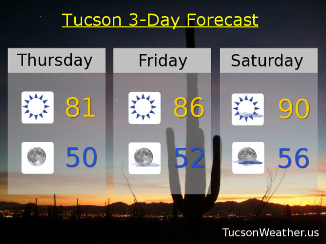
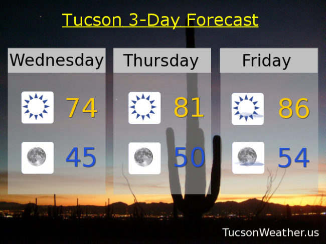
Partly sunny Easter Sunday and warm with a high in the upper 80s. Mostly sunny Monday mid 80s. Sunny Tuesday mid 80s. Mostly sunny Upper 80s Wednesday, Thursday and Friday. Enjoy!

Forecast for Friday, March 30, 2018

Temperatures still going up as high pressure continues to build in, peaking tomorrow near the record high of 91. We’ll see. It’s a dirty high meaning there will be high clouds from time to time hopefully leading to sunrise and sunset enhancement! Considerable high cloudiness Sunday into Monday not out of the question and maybe even a few sprinkles. It shouldn’t amount to anything. It’ll stay warm too. Enjoy!

Sunny today upper 80s. Mostly sunny tomorrow near 90. Partly sunny Easter Sunday upper 80s. Becoming mostly sunny Monday mid 80s. Sunny Tuesday and Wednesday upper 80s. Mostly sunny Thursday upper 80s.

Forecast for Thursday, March 29, 2018

March came in like a lamb and is going out like a lamb. Is that supposed to even happen?! High pressure building in with high temperatures soaring higher. Some weak troughiness this weekend will add some cloudiness for possible sunrise and sunset enhancement and “cool” us just a bit by Easter Sunday, but it will still be on the warm side. Staying dry until further notice as well.

Sunny today 81ish.

Clear skies tonight near 50.

Sunny tomorrow mid 80s. Mostly sunny Saturday near 90. Partly sunny Sunday upper 80s. Mostly sunny Monday mid 80s. Sunny Tuesday mid 80s. Upper 80s Wednesday. Enjoy!

Forecast for Wednesday, March 28, 2018

The (mostly) dry system that brought us a cool breeze has exited into New Mexico and high pressure will start building in today for a nice warming trend (if you’re into that sort of thing). Today’s expected high of 74 is still 3 degrees below average for this time of year and rather pleasant. WNW breezes only 5-10 mph ish so there’s also that.

Clear skies tonight with a low in the mid 40s.

Sunny tomorrow low 80s. Mid 80s Friday. Upper 80s to near 90 Saturday. Upper 80s Sunday. Mid 80s Monday and Tuesday. Enjoy!

Forecast for Tuesday, March 27, 2018

Our upper level low will bring snow showers to the White Mountains today as it exits stage east. For Tucson we will see mostly sunny skies and cool temperatures behind the storm. NW breezes just 5-10 mph ish and a not so high high in the upper 60s.

Mostly clear skies tonight with a low in the low 40s.

Warming up starting tomorrow with a high in the mid 70s. Low 80s Thursday. Mid 80s Friday. Upper 80s Saturday and Sunday. Low 80s Monday. Enjoy!