Monthly Archives: March 2018

Forecast for Monday, March 26, 2018

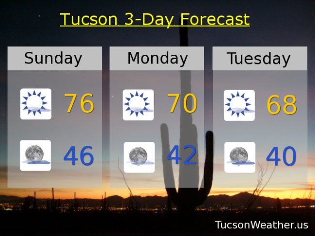
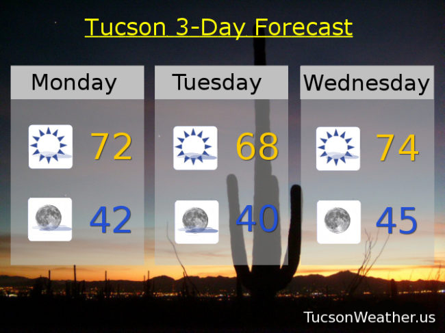
Another breezy day today as our next storm approacheth. Considerable high cloudiness overnight has left us with a fairly mild morning. Clouds will be clearing but even with a lot of sunshine we’ll only top out in the low 70s this afternoon. West winds picking up as we go and should be around 10-20 mph by this afternoon.

Mostly clear skies tonight and still a bit breezy. Southerly winds 5-15 mph and a low in the low 40s.

The storm moves through tomorrow but it is moisture deficient. It will be a cool day with plenty of sunshine and highs in the upper 60s with a WNW breeze.

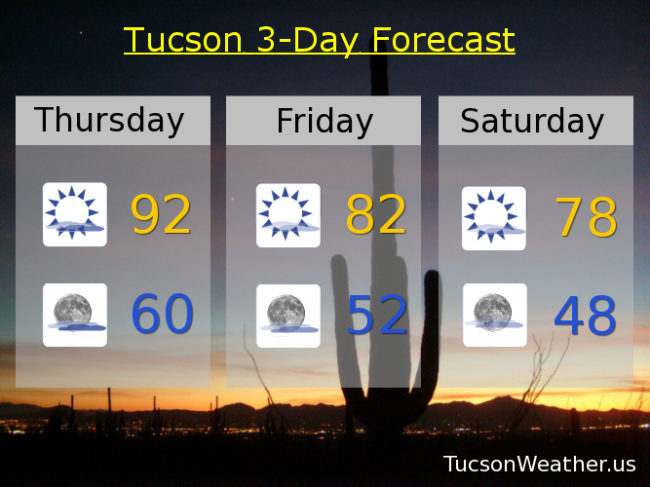
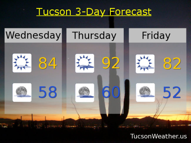
A warming trend commences on Wednesday through the weekend as our old pal high pressure builds back in. Mid 70s Wednesday. Low 80s Thursday. Mid 80s Friday. Upper 80s Saturday. Mid 80s Sunday. Enjoy!

Forecast for Sunday, March 25, 2018

Now back to our regularly scheduled programming… Yesterday’s wind maker has moved off to the east, but still some lingering breeziness this afternoon. West winds 5-15 mph and gusty isn’t that bad. Perfect for flying a kite, but not quite “being a kite” levels. A few high clouds moving in this afternoon for possible sunset enhancement, otherwise mostly sunny near 76ish this afternoon.

Partly cloudy tonight mid 40s.

Our next wind maker approacheth tomorrow and moves across the northern part of the state Tuesday. It’s a dry storm but it will knock our temperatures back. Sunny tomorrow with west winds 10-20 mph and gusty with a high near 70ish.

Mostly sunny Tuesday with a gusty NW breeze and cooler with a high only in the upper 60s.

Warming up the rest of the week as our old pal high pressure returns. Mid 70s Wednesday. Low 80s Thursday. Upper 80s Friday and Saturday.

Forecast for Thursday, March 22, 2018

Our old pal high pressure is turning up the heat! and despite considerable high cloudiness today we are still expecting to break today’s record of 90. SE breezes 5-15 mph becoming SWesterly this afternoon.

Mostly cloudy tonight keeping “things” mild with a low near 60.

The system to our north bringing the clouds will exit to the east leaving some “cooler” air in its wake. Mostly sunny tomorrow with a high in the low 80s and a westerly breeze 5-15 mph.

Mostly sunny Saturday upper 70s. Mid 70s Sunday. Near 70 Monday and Tuesday. Another system headed our general direction will give us a slight chance for light rain Wednesday with a high in the upper 60s. Enjoy!

Forecast for Wednesday, March 21, 2018

High pressure large and in charge the next couple of days. Probably a new record high tomorrow in the low 90s besting the record of 90 last hit in 1990. A system approacheth but will miss us to the north, so no rain, but we will see quite a bit of high cloudiness tomorrow and a bit breezy. The system misses us to the north Friday knocking our temperatures back down in time for the weekend. Another storm misses us to the north early next week for further cooling, but staying dry. Enjoy!

Mostly sunny today with a high in the mid 80s.

Partly cloudy tonight with a low in the upper 50s.

Partly sunny tomorrow and breezy with a SE wind 5-15 mph becoming SSW in the afternoon and a high in the low 90s.

Mostly sunny Friday low 80s. Near 80 Saturday. Mid 70s Sunday. Near 70 Monday. Low 70s Tuesday.