Monthly Archives: March 2018

Forecast for Tuesday, March 20, 2018

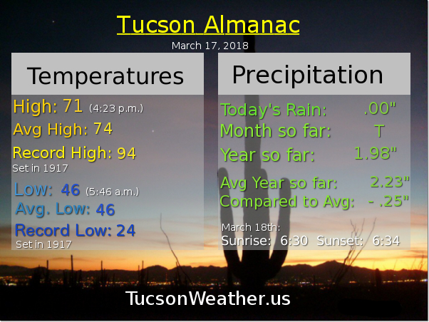
Meteorological Spring is the calendar months of March, April and May. Astronomically speaking Spring starts today. The Sun will be directly over the equator at 9:15 this morning Tucson time. You might feel a little dizzy. Dogs may be barking. If you are doing the dishes you might drop and break one. 🙂 Of course none of that is true… except the Vernal Equinox is at 9:15. Equinox meaning equal night (Latin). In a perfectly spherically shaped world with no atmosphere we would have exactly 12 hours of daylight and 12 hours of nighty night across the entire planet. But, the atmosphere actually bends the incoming  sunlight so the Sun appears to rise a few minutes before it actually does and appears to set a few minutes after it actually does. Throws the whole Equinox off a bit, but it’s still close.

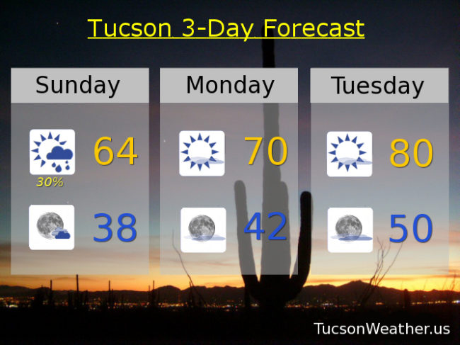
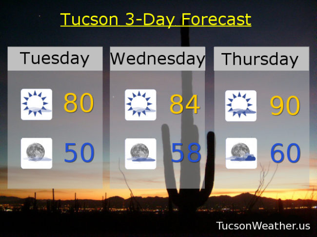
The first day of Spring in Tucson looks pretty outstanding! Lots of sunshine today with a high near 80.

Mostly clear skies tonight with a low near 50.

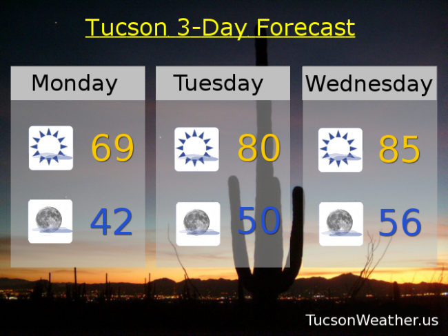
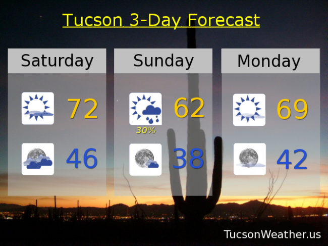
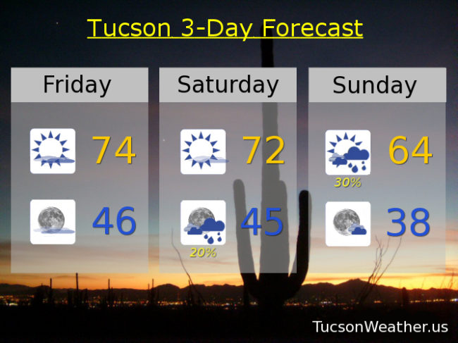
High pressure continues to flex the next couple of days. Sunny tomorrow 84ish. High clouds moving in Wednesday through Friday. Thursday the warmest day of the week despite the cloud cover with a high near the record of 90. Cooler Friday as a system misses us to the north near 80. Mostly sunny Saturday upper 70s. Mid 70s Sunday and Monday. Enjoy!

Forecast for Monday, March 19, 2018

Only 63 for a high yesterday which is 12 degrees below average. A few brief showers around the area in the morning missing the official rain gauge at the airport. A warming trend begins today after a chilly start (mmm chili). A few high clouds as we go for possible sunrise and sunset enhancement. Thursday’s expected high of 90, if realized, will tie the record and be our first 90 degree day of the year. Then a storm misses us to the north for a very slight chance of rain and knocking high temperatures back into the 70s. Here we go!

Mostly sunny today with a high near 69.

Mostly clear tonight low 40s.

Near 80ish tomorrow. Mid 80s Wednesday. Near 90 Thursday. Slight chance for showers Friday upper 70s. Sunny Saturday and Sunday upper 70s.

Forecast for Sunday, March 18, 2018

Still a chance for showers this morning, but as I write this at 6:45ish in the morning, still nothing. Most of the computer models are still showing some light rain across the area, but a couple models say we will stay dry, so it’s possible we might get skunked. Still a chance for an inch or two of snow in the mountains. Winds becoming WNWesterly 5-15 mph and gusty once the front moves through. Clearing skies this afternoon with a high only 64ish.

Partly cloudy tonight with a low in the upper 30s!

Mostly sunny tomorrow near 70. Near 80 Tuesday. Mid 80s Wednesday!

Another storm approacheth Thursday with mostly cloudy skies low 80s. Slight chance for light rain Thursday night and Friday. Friday upper 70s. Sunny upper 70s Saturday. Enjoy!

Forecast for Saturday, March 17, 2018

Top o’ the afternoon to ya! Sorry for the late update, but I wanted to make sure I didn’t skip today because we have a bit o’ excitement headed our way tonight/tomorrow. A storm approacheth and the wind has been picking up a bit this afternoon. Clouds will be on the increase tonight with a cold front blowing through sometime around 3am – 5am. Most of our expected rainfall should occur ahead of and near the front. Not a lot of moisture to work with and the main system will be to our north, so likely less than a tenth of an inch for most valley locations. An inch or three of snow possible above 5,500 – 6.000 feet, so a little bit. Rain ends tomorrow morning with clearing skies by afternoon and much cooler with a high only near 62. Gusty SSW winds overnight relaxing some during the day tomorrow.

Mostly sunny Monday with a high near 69. Upper 70s Tuesday.

Another storm missing us to the north will give us more clouds Wednesday and a slight chance of rain Thursday. Low 80s both days. Slight chance for a lingering shower Friday mid 70s. Sunny Saturday mid 70s. Enjoy!

Forecast for Friday, March 16, 2018

It’s Friiidaaay!!!

Our next storm approacheth. Our exiting system that brought snow to northern Arizona cooled us off quite a bit yesterday with a high of 70. A little warmer today as slight ridging occurs ahead of our next storm currently off the northern California coast.

High clouds, thick at times, today with a high in the mid 70s.

Partly cloudy tonight with a low in the mid 40s.

Mostly sunny tomorrow with a high in the low 70s.

Then our system moves into Arizona Saturday and moves through Sunday. Pretty good chance for showers but they should be on the light side Saturday night and Sunday morning. Only expecting a tenth of an inch or less in valley locations. A little bit of snow above 6,000 feet in our local mountains. Showers likely ending by Noon Sunday with a high only in the mid 60s.

Mostly sunny Monday after a chilly start (mmm chili) with a high in the upper 60s to near 70. Upper 70s Tuesday. Mid 80s (or warmer) Wednesday. Low 80s Thursday. Enjoy!