Monthly Archives: January 2019

Forecast for Thursday, January 31, 2019

Farewell sweet January. We hardly knew thee! Really nice day for my birthday yesterday. High of 72 after a low of 46. Both values above our seasonal averages of 67 and 41. A weakening system approacheth to close out the first month of 2019. Less clouds than yesterday today, but still enough for possible sunrise and sunset enhancement possibilities. One last chance to add to our January rain totals late tonight as the system moves through. Rain lingers into tomorrow before Noon before we clear out temporarily. Only expecting a tenth of an inch or less from this first storm. Summerhaven expecting both rain and snow, so no real snow accumulations there although the ski area might pick up an inch or three. Exit storm one tomorrow and enter storm two this weekend. This one has more moisture so perhaps a quarter inch or more for valley locations. Summerhaven might get an inch or three from this storm. Prime time for precipitation looks to be Saturday night into Sunday. What will storm number three do? That is still up in the air (see what I did there?). The official forecast keeps Monday and Tuesday dry but there are some indications that that might not stay the case. Stay tuned!

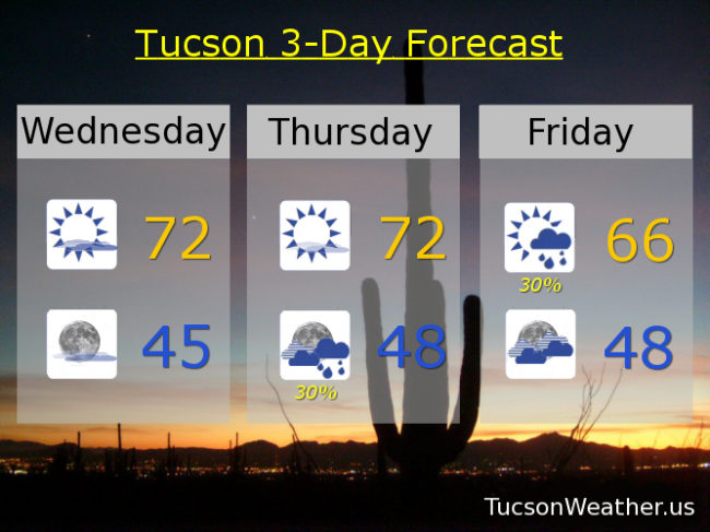
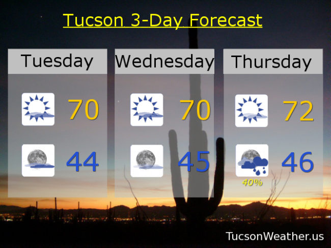
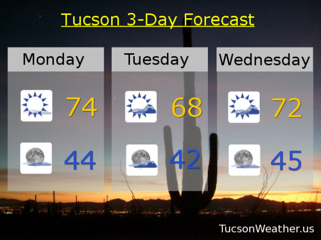
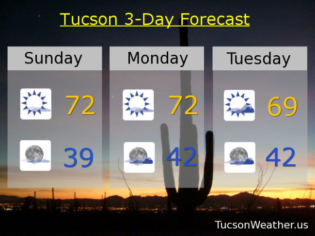
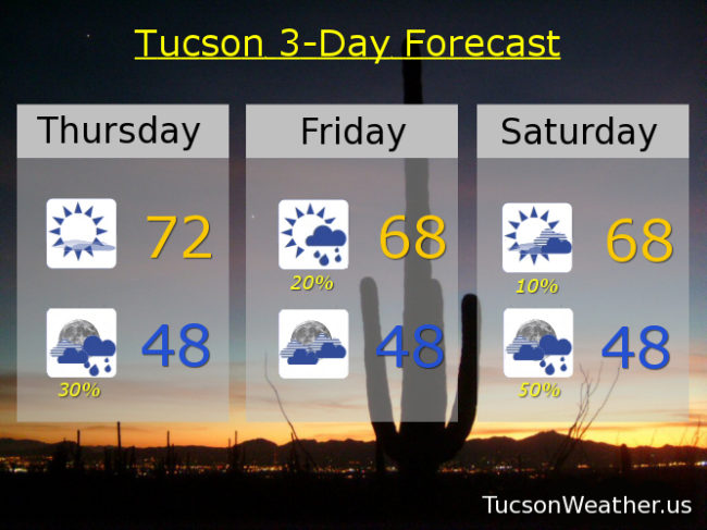
Mostly sunny today with a high in the low 70s. Mostly cloudy tonight with a 30% chance for showers and a low in the upper 40s. Becoming mostly sunny tomorrow with a 20% chance for morning showers and a high in the upper 60s. 10% Saturday upper 60s. 50% Saturday night upper 40s. 30% Sunday mid 60s. Mostly sunny Monday, Tuesday and Wednesday low 60s. Enjoy!

Forecast for Wednesday, January 30, 2019

Winter is returning to us as a series of storms are fixin’ to head our way. Storm numero uno is approaching the central California coast and then will proceed to approacheth Arizona. As it moves through Thursday night into Friday we’ll see showers developing and snow above 7,500 – 8,000 feet. Not much snow accumulation in Summerhaven from this first storm, but the ski area could see an inch or three. Here in the lowlands we are expecting a few hundreths up to a quarter of an inch with prime time for rain being late tomorrow night into Friday morning. Storm numero dos will be right on it’s heels. This one is a bit colder and stronger. Three to eight inches of snow perhaps for Summerhaven this weekend and up to a half inch of rain in the Metro. Storm numero tres? ETA is Monday night into Wednesday. Still a lot of question marks with the main question being how much moisture will it bring. It will be the coldest of the three. We’ll just have to stay tuned!

Partly sunny today with a high in the low 70s. Partly cloudy tonight mid 40s. Mostly sunny tomorrow low 70s. 30% late tomorrow night into Friday. Friday’s high 66ish. 20% Saturday upper 60s. 40% Saturday night mid 40s. 30% Sunday mid 60s. 10% Monday low 60s. 20% Monday night low 40s. 20% Tuesday low 60s. Enjoy!

Forecast for Tuesday, January 29, 2019

Well that escalated quickly… or will. Rain in the forecast and the pattern change that is coming should open the door for a few storms to move through. Considerable high cloudiness at times through tomorrow with some breaks in the clouds as well. Could lead to some great sunrise and sunset enhancement! Or. The clouds will be too thick and we’ll get skunked like yesterday evening. Keep those 35mm cameras handy and get ready to run down to the One Hour Photo Moto! A small but vigorous upper level low near the central California coast will move south and displace our high pressure to the west. The low is then expected to weaken some and move across the area. Rain showers for us bottom dwellers and snow above 7,500 feet in the forecast Thursday night into Friday. Only a tenth of an inch of rain or less expected in the Metro and an inch or three of snow in Summerhaven. Another storm on the heels of the first should be in here just in time for the weekend. Much more moisture to work with. We could see up to three-quarters of an inch of rain, but we are a ways out, so don’t quote me on that just yet. Rain ending Sunday with yet another system following in behind. The third one looks to be colder, so lower mountain snows early next week. You know, assuming this all comes true. Stay tuned!

Partly sunny today and tomorrow with highs near 70ish. Mostly cloudy tonight and partly cloudy tomorrow night with lows in the mid 40s. Mostly sunny Thursday low 70s. Scattered showers Thursday night mid 40s. Isolated showers Friday morning becoming mostly sunny upper 60s. 20% Saturday upper 60s. 40% Saturday night mid 40s. 20% Sunday mid 60s. 10% Monday low 60s. Enjoy!

Forecast for Monday, January 28, 2019

The times they are a changin’. Rain is back in the forecast by the end of the week and into the weekend! High pressure still to our west with some high clouds later today into tonight for possible sunset enhancement. Keep those camera devices handy. A system missing us to the north will give us partly sunny to mostly cloudy skies tomorrow into Wednesday. On Wednesday a storm off the central California coast will start to break down the high to our west and open the door for a stronger storm this weekend. Perhaps some light showers (half the calories of our regular showers) on Friday with a bit of snow above 7,500 feet. Then a better chance for rain and mountain snow Saturday and Saturday night. Stay tuned!

Sunny today with some high cloudiness and a high in the mid 70s. Partly cloudy tonight with a low in the mid 40s. Mostly cloudy tomorrow upper 60s. Partly sunny Wednesday low 70s. Mostly sunny Thursday low 70s. 10% chance for showers Friday upper 60s. 20% Saturday upper 60s. 30% Saturday night low 40s. Mostly sunny Sunday 65ish. Enjoy!

Forecast for Sunday, January 27, 2019

Freezing again yesterday! A low of 32 to start the weekend with a high topping at exactly average for this time of year (66). Warmer this morning and this afternoon with some thin high clouds from time to time for possible sunrise and sunset enhancement. More and thicker clouds in here by Monday night and hanging out through Tuesday night. High pressure remains to our west but changes are coming by next weekend. Models are at odds on what will happen exactly. Some say we’ll stay dry next weekend. Others bring in a strong low with valley rain and mountain snow. Right now the smart money is on the drier forecast, but if you like to play the odds go for rain a week from now for a bigger payoff. Either way, it looks like a pattern change to start February. We’ll let the models crunch the numbers (that’s what they do) and see if they can agree by the end of the week. Place your bets and stay tuned!

Sunny today with a high in the low 70s. Mostly clear tonight upper 30s. Sunny tomorrow low 70s. Mostly cloudy Tuesday upper 60s. Mostly sunny Wednesday low 70s. Sunny Thursday low 70s. Sunny Friday near 70ish. Mostly sunny Saturday 70. Enjoy!