Monthly Archives: January 2019

Forecast for Saturday, January 26, 2019

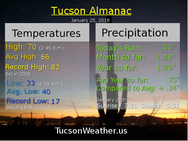
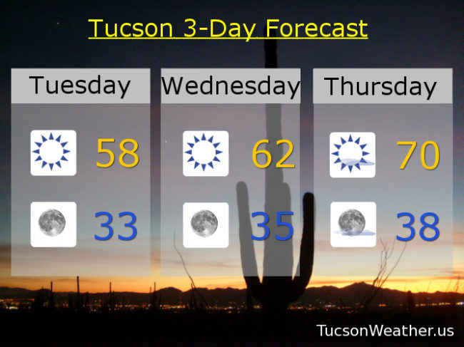
Subtle changes that we’ll tweak as we go. High pressure still to our west and we remain in a NW flow. A weak disturbance in the force brought a few high clouds last night and minor cooling today. We are starting out in the low to mid 30s once again this morning with a high expected just a couple of degrees above the January average of (Route) 66. A bit warmer tomorrow and Monday as high pressure noses in just a bit. The pattern switches slightly to a more westerly flow Monday night into Tuesday with more clouds and some cooling as another disturbance rides through. Then it’s mostly sunshine and a bit warmer for the rest of the week. Staying dry, but a hint of some showers to our east maybe Tuesday and Tuesday night. Stay tuned!

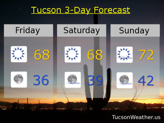
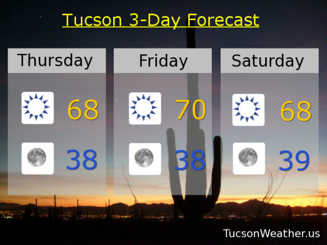
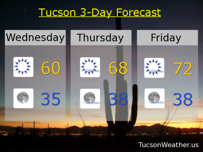
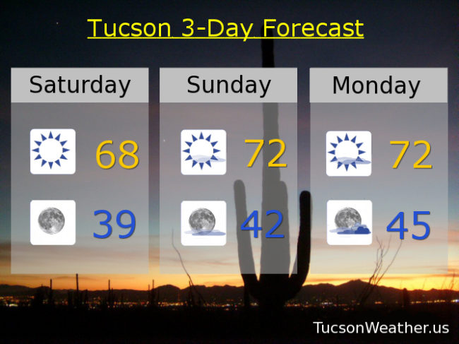
Sunny today with a high in the upper 60s. Clear tonight upper 30s. Mostly sunny tomorrow and Monday low 70s. Partly sunny Tuesday upper 60s. Sunny for my birthday near 70ish. Mostly sunny Thursday and Friday low 70s. Enjoy!

Forecast for Friday, January 25, 2019

It’s Friiidaaay!!!

Yesterday we topped out at exactly average for this time of year with a high of 66. We started the day freezing! (32) which is 8 degrees below average. Mid 30s right now at the airport and today’s high should be a couple of degrees warmer. Lots of sunshine through the weekend, but a few high clouds might give us some sunrise and/or sunset enhancement opportunities. Keep your Nikon Canon Sony Pentax Olympus iPhone Android devices handy just in case. Warming up a bit this weekend with high pressure remaining to our east. A system missing us to the north and east early next week will give us more clouds and cooler temperatures, but we stay through my birthday. Stay tuned!

Sunny today with a high in the upper 60s. Clear tonight mid 30s. Upper 60s tomorrow. Low 70s Sunday and Monday. Mostly sunny Monday 72ish. Partly sunny Tuesday mid 60s. Sunny Wednesday and Thursday low 70s. Enjoy!

Forecast for Thursday, January 24, 2019

Happy Friday Eve! It makes the weekend seem closer…

All quiet on the western front. Some might call it boring even. High pressure to the west will keep us in a NW flow. A couple of weak disturbances in the force will keep us from warming up too much, but we will warm up some. No rain and barely any clouds in the forecast through the weekend. Staying chilly at night (mmm chili) with lows in the upper 30s to low 40s into next week. Highs bouncing back and forth from the upper 60s to low 70s. Stay Tuned!

Sunny today with a high in the upper 60s. Clear tonight with a low in the upper 30s. Sunny tomorrow near 70ish. Upper 60s Saturday. Low 70s Sunday and Monday. Partly sunny Tuesday upper 60s. Sunny Wednesday upper 60s. Enjoy!

Forecast for Wednesday, January 23, 2019

It was chilly yesterday (mmm chili) with a bit of a NW breeze adding an extra chill especially if you were in the shade. Let the warming trend begin! Although today won’t be all that warm it will still be warmer than yesterday’s high of 56. 70s return by Friday and last through the weekend. Slight cool off early next week but staying dry. Stay tuned!

Sunny today near 60ish. Clear tonight mid 30s. Sunny tomorrow upper 60s. Low 70s Friday. Upper 60s to near 70 Saturday. Low 70s Sunday and Monday. Upper 60s Tuesday. Enjoy!

Forecast for Tuesday, January 22, 2019

Meteorology. Meteor from the Greek meaning “from the sky” and ology is “the study of”. So. When I tell you I saw a small fireball or “large” (larger than the usual grain to pebble size) just before 4:50 this morning, that totally fits what we are doing here. Even though I’m not a meteorologist, I sorta play one on FB 🙂 Anyway, it was travelling north to south and I saw a couple pieces break off of the main meteor as it burned across the southern Arizona sky. Pretty cool way to start that day! It was also cool out on the deck with my first cup of coffee. Officially we are starting out in the upper 30s with a wind chill (yes, a wind chill!) in the mid 30s. The cold air is still settling in behind yesterday’s cold front. The good news is that the wind will be relaxing today. The bad news is today’s high will only be in the 50s with a low near freezing tonight. My plants on the deck don’t mind. They get to come in and watch TV! Warming up as we go through the week with a return of that 70s show by Thursday and rerunning through the weekend. Stay tuned!

Sunny today with a high in the upper 50s. Clear tonight near freezing. Sunny low 60s tomorrow. Near 70ish Thursday. Low 70s Friday. Near 70ish Saturday. Low 70s Sunday and Monday. Enjoy!