Monthly Archives: November 2018

Forecast for Friday, November 30, 2018

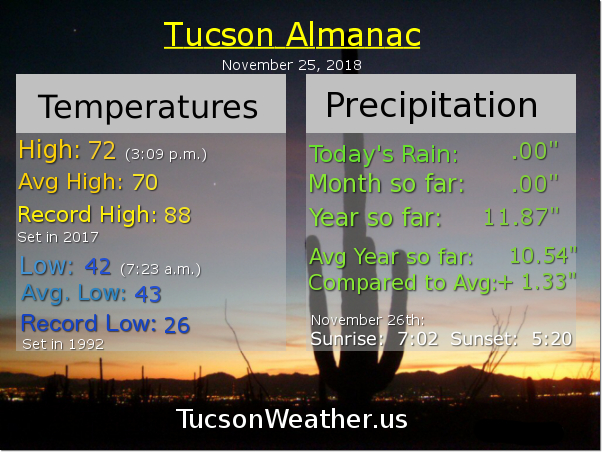
I for one welcome our new Winter overlords! Cold front blew through just after 3am with an area of moderate to heavy rain and even a rumble of thunder or three. The National Weather Service says about a quarter inch fell at the Marana Airport. Looks like only .07″ officially for the Tucson International Airport, so as usual, your individual mileage may vary. Looks like a few inches of snow in Summerhaven this morning with more possible and a WINTER WEATHER ADVISORY still in effect until Noon above 7,000 feet. Be advised. There may be Winter weather above 7,000 feet.

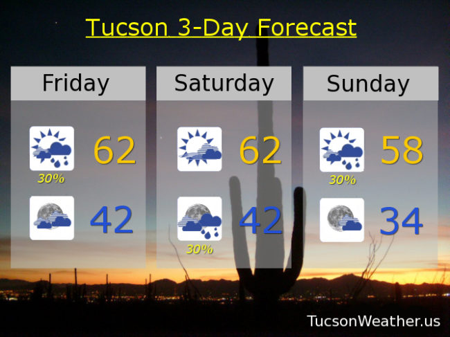
Valley rain showers have pretty much ended this morning but isolated showers still possible this afternoon as a disturbance in the force moves through behind the front later today. A bit of a break in the action tomorrow although we’ll keep some cloudiness around. Nice and cool with temperatures below the average high of 69 for this time of year. Another system rotates through Saturday night and Sunday with another round of valley rain and mountain snow. Snow levels will be about 1,000 feet lower with this one.

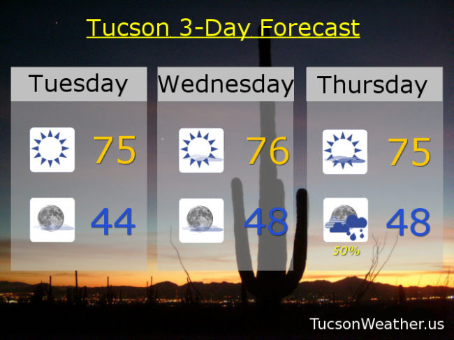
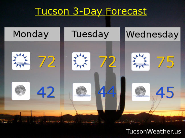
Then it gets chilly. (mmm chili) Lows Monday and Tuesday morning in the mid 30s! Our first freeze of the year in the Metro not out of the question. Then a warming trend for a couple of days before our next system Thursday. Maybe not a doozy after all, but another shot of valley rain and mountain snow. Stay tuned!

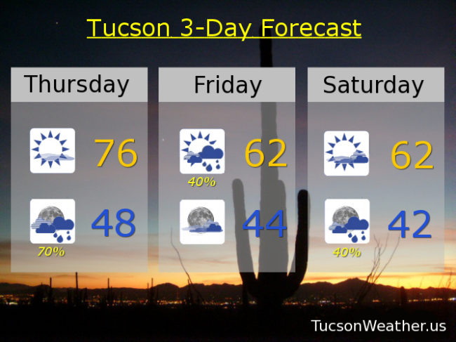
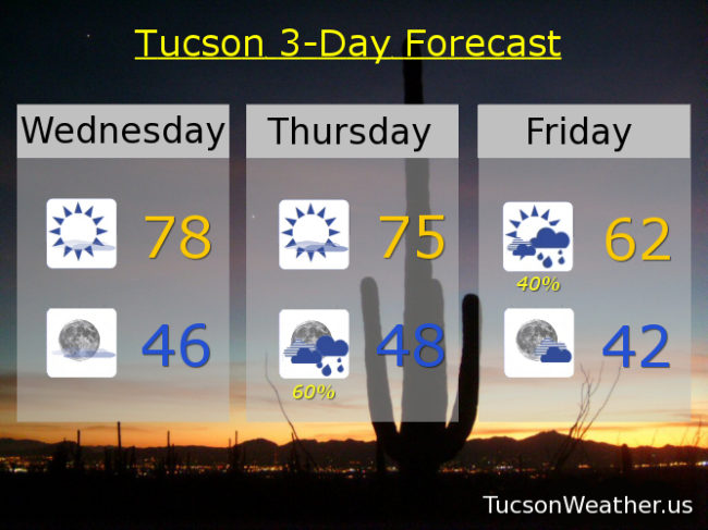
30% chance for showers today and a high in the low 60s. NW breezes 5-15 mph and gusty becoming SSWesterly. Mostly cloudy tonight low 40s. Partly sunny tomorrow low 60s. 30% chance for showers tomorrow night and Sunday. Sunday’s high in the upper 50s. Sunny Monday low 60s. Upper 60s Tuesday. Low 70s Wednesday. 30% chance for showers Thursday mid 60s.

Forecast for Thursday, November 29, 2018

Get your red hot cold fronts here! A cold system is moving onshore in California even as I type. It will make steady progress our way throughout the day with SE breezes and high cloudiness ahead of it. Hopefully we’ll manage some sunrise and sunset enhancement! The storm moves through tonight dragging a strong cold front through the area late tonight into tomorrow morning. Showers and mountain snow along and behind the front with 3″-5″ inches possible for Summerhaven. A disturbance in the force riding through tomorrow should give us another round of showers and mountain snow during the day. Summerhaven could pick up another inch. A break in the action but cool Saturday with plenty of clouds around. Another disturbance moving through Saturday night and Sunday with another round of rain and mountain snow. Snow levels down to 5,500 feet or lower. The whole thing moves out Monday and we start a warming trend. Then all eyes are on Thursday/Friday of next week. Still a ways away, but it looks like a strong, cold storm could be headed our way. It could be what we call, a doozy! Stay tuned!

Mostly sunny and breezy today with SE breezes 10-20 mph and gusty with a high in the mid 70s. Showers likely tonight (70%) with a low in the upper 40s. 40% chance for showers tomorrow with a high in the low 60s. Partly sunny Saturday low 60s. 40% chance for showers Saturday night and Sunday. Sunday’s high in the upper 50s. Sunny Monday near 58ish. Mid 60s Tuesday. Upper 60s Wednesday. Enjoy!


Forecast for Wednesday, November 28, 2018

76 yesterday was just stupendous! Splendiferous again today with a few high clouds, hopefully with some sunrise and sunset enhancement, and a high in the upper 70s! Don’t get too used to it, or rather enjoy it while you can. Still warm tomorrow but the ESE breeze kicking up in front of a rather strong cold front that will blow through Thursday night. Showers likely along and behind the front and by definition of a cold front, colder. Then another system rides through (howdy partner) bringing a chance for showers Saturday night into Monday. Even colder temperatures with lows in the mid 30s Monday and Tuesday mornings! Mountain snow too with snow levels starting around 7,500 feet tomorrow night dropping to around 6,500 feet by the time the showers end on Friday. Snow levels starting around 6,500 feet Saturday night going below 5,500 feet before our second system is done. 1″-3″ possible with the first system say above 7,000 feet. Not sure about snow amounts yet with the second, but snow levels will be lower. Hints of maybe another storm next week, but we’ll burn that bridge when we get to it. Stay tuned!

Sunny today with a high near 78ish. Mostly clear tonight with a low in the mid 40s. Mostly sunny tomorrow with an ESE breeze 10-20 mph and gusty mid 70s. Showers likely (60%) Thursday night with a chance for showers Friday morning (40%) with a high Friday afternoon in the low 60s. Mostly sunny Saturday low 60s. Slight chance for showers (20%) Saturday night with a 40% (40%) chance Sunday and a high Sunday afternoon in the upper 50s. Slight chance for showers Sunday night (20%) and a low in the mid 30s! 10% chance Monday upper 50s. Sunny Tuesday low 60s. Yee Haw!

Forecast for Tuesday, November 27, 2018

Happy Turkey Sandwich Tuesday! You can always make it a twofer and get through those leftovers faster.

Here comes Winter! I stole that from the National Weather Service Forecast Discussion. You should read that everyday. Link below. A couple three storms heading our direction and the computer models agree we have a good chance for valley rain and mountain snow. How low will the snow level go? The answer my friends is still blowing in the wind, but stay tuned.

I don’t want to be so future minded that I forget to live in the moment. A bit of high pressure still with us today and tomorrow for warm afternoons after refreshingly cool morning lows. Winds picking up out of the SE Thursday as our first storm approacheth. Good chance for showers Thursday night and mountain snow with snow levels dropping to near 6,500 feet as the storm exits Friday, so probably not enough for sledding… Yet.

Storm number two in here for the tail end of the weekend. It’s colder, which makes sense, because meteorologically speaking Winter starts on December 1st. Highs only in the upper 50s Sunday and Monday with a chance for rain and snow levels perhaps as low as 4,500 feet! Another system following this one? More specifics as we get closer. Again. Stay tuned!

Sunny and nice today and tomorrow with highs in the mid 70s. Low tonight in the mid 40s. Sunny and breezy Thursday with SE winds 5-15 mph and gusty with a high in the mid 70s. 50% chance for showers Thursday night and 20% Friday with a high Friday in the low 60s. Mostly sunny Saturday mid 60s. 30% chance for showers Sunday and 10% Monday upper 50s. Enjoy!

Tucson National Weather Service Forecast Discussion: https://forecast.weather.gov/product.php?site=TWC&issuedby=TWC&product=AFD&format=CI&version=1&glossary=1

Forecast for Monday, November 26, 2018

You better watch out. You better not cry. You better not pout I’m telling you why. A couple of storm systems are coming to town… or something like that.

A few high clouds in the mix today for possible sunrise and sunset possibilities perhaps. Clearing out by this evening as high pressure noses in for the next couple of days. Highs will be higher with a lot of sunshine on your shoulder. A few more clouds Thursday as our first storm approacheth. Chance for valley rain and mountain snow Thursday night into Friday. Snow levels dropping as low as 6,500 feet but not until the tail end of the storm. Perhaps another storm for Sunday/Monday but the models can’t agree on stuff. So. We are going to lock them into a room until they can get along. Until then Stay Tuned!

Sunny today with a few high clouds and a high in the low 70s. Clear skies tonight low 40s. Sunny tomorrow low 70s. Mid 70s Wednesday. Low 70s Thursday. 20% chance for showers Thursday night and Friday with a high Friday afternoon in the low 60s. Mostly sunny low 60s Saturday, and Sunday.