76 yesterday was just stupendous! Splendiferous again today with a few high clouds, hopefully with some sunrise and sunset enhancement, and a high in the upper 70s! Don’t get too used to it, or rather enjoy it while you can. Still warm tomorrow but the ESE breeze kicking up in front of a rather strong cold front that will blow through Thursday night. Showers likely along and behind the front and by definition of a cold front, colder. Then another system rides through (howdy partner) bringing a chance for showers Saturday night into Monday. Even colder temperatures with lows in the mid 30s Monday and Tuesday mornings! Mountain snow too with snow levels starting around 7,500 feet tomorrow night dropping to around 6,500 feet by the time the showers end on Friday. Snow levels starting around 6,500 feet Saturday night going below 5,500 feet before our second system is done. 1″-3″ possible with the first system say above 7,000 feet. Not sure about snow amounts yet with the second, but snow levels will be lower. Hints of maybe another storm next week, but we’ll burn that bridge when we get to it. Stay tuned!
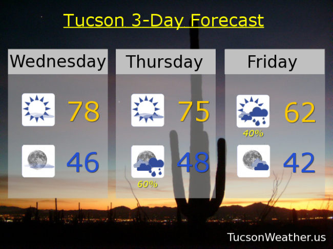
Sunny today with a high near 78ish. Mostly clear tonight with a low in the mid 40s. Mostly sunny tomorrow with an ESE breeze 10-20 mph and gusty mid 70s. Showers likely (60%) Thursday night with a chance for showers Friday morning (40%) with a high Friday afternoon in the low 60s. Mostly sunny Saturday low 60s. Slight chance for showers (20%) Saturday night with a 40% (40%) chance Sunday and a high Sunday afternoon in the upper 50s. Slight chance for showers Sunday night (20%) and a low in the mid 30s! 10% chance Monday upper 50s. Sunny Tuesday low 60s. Yee Haw!