Monthly Archives: March 2019

Forecast for Saturday, March 16, 2019

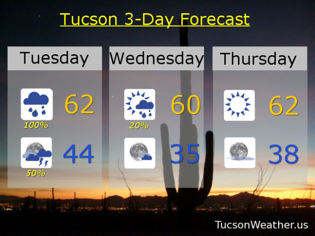
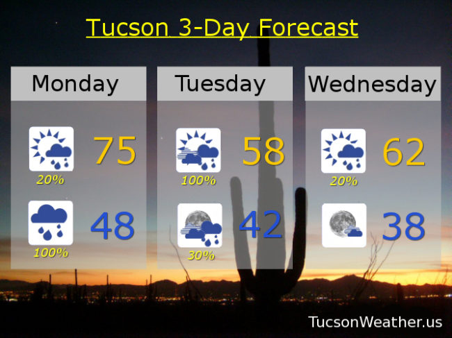
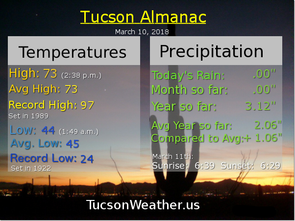
Well that escalated quickly! An upper level low centered near Rocky Point this morning has pulled some moisture northward and as it appraoceth today we could add enough instability for the National Weather Service to introduce thunderstorms to our forecast! (thunderstorms meet forecast. Forecast, thunderstorms) It’s one of the things I love about weather. It can still surprise us. Still a bit of an east wind today but not as breezy as the last couple of days. Our old pal high pressure still fixin’ to move our way to start next week with the 80s making a comeback! (I wanted to be with you alone. and talk about the weather…) Another storm heading our way by Thursday for cooler Tucson Weather and a chance for showers.

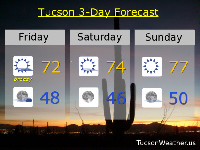
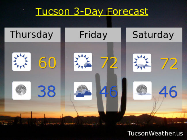
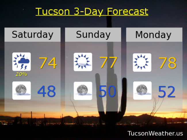
Mostly sunny today with a 20% chance for thunderstorms. East breezes 10-15 mph and gusty. Today’s high in the mid 70s. Mostly clear tonight upper 40s. Sunny tomorrow and Monday upper 70s. Low 80s Tuesday and Wednesday. 10% Thursday mid 70s. 20% Thursday night upper 40s. Mostly sunny Friday low 70s. Enjoy!

This section is the hard part. I have excepted a job that requires extensive travel and a pretty good chance that I will be moving to Phoenix. I start on Monday. So. This is my last forecast on this page and at tucsonweather.us. I’ve been doing this every morning (with rare exception) for the last almost 9 years! We’ve built a solid community of weather enthusiasts and I hate to let it go. Unfortunately I don’t see how I can continue with my new responsibilities. Thank you all SO MUCH. To the Patreons, I will be shutting that down today most likely. Amazing that some of you would think that my fun hobby is worthy of financial support. I’ll keep the Facebook page open and maybe even post from time to time. THANK YOU!!!

Forecast for Friday, March 15, 2019

Beware the Ides of March! Backstabbers are one thing. Today’s east wind is another. High pressure building to our east will cause our east winds to increase today. Prolly gusting over 30 mph at times. A weak and dry system approacheth from California and will move over the state tonight and tomorrow with some clouds and breezy conditions. Even still a warming trend commenceth today into next week. The 80s return perhaps as early as Monday! Could see showers and some cooling late in the week. Enjoy!

Increasing clouds and increasing breezes with east winds 15-25 mph gusting over 30. Today’s high in the low 70s. Partly cloudy and breezy tonight with east winds 15-20 mph and gusty. Tonight’s low in the upper 40s. Sunny tomorrow with east breezes 10-20 mph and a high in the mid 70s. Sunny Sunday upper 70s. Upper 70s to near 80ish Monday. Low 80s Tuesday and Wednesday. Mostly sunny with a 10% chance for showers Thursday mid 70s.

Forecast for Thursday, March 14, 2019

Happy Friday Eve! It makes the weekend seem closer.

Chilly this morning (mmm chili) and not all that warm this afternoon behind our exited system. A little disturbance in the force will briefly increase some clouds up in here tomorrow and tomorrow night, but it won’t last. Mostly we are looking at a GREAT weekend. Even warmer next week with some 80s in the forecast. A late week storm may bring some rain and high mountain snow, but we’ll burn that bridge when we get to it. Stay tuned!

Sunny today with a high near 60ish. Clear tonight with a low in the upper 30s. Increasing clouds tomorrow with a high in the low 70s. Sunny Saturday low 70s. Upper 70s Sunday and Monday. Low 80s Tuesday and Wednesday. Enjoy!

Forecast for Tuesday, March 12, 2019

Growing up in Oregon, whenever it rained (like all the time) my Dad would ask us kids, “think it’ll rain?” So. As southern Arizona does a credible Oregon impression I ask you, “think it’ll rain?!” How about a 100% chance today as our upper level low is still to our west in Baja California. As it moves across tonight we’ll even see a chance for a thunderstorm or three thrown in to the shower mix! Rain is just starting to change to snow this morning in Summerhaven. A WINTER STORM WARNING is still in effect there until 8:00 tonight. Lingering showers and kinda windy on Windsday as the storm exits stage east. Then a warming trend with pleasantville temperatures this weekend. Enjoy!

A 100% chance for more showers today and a high in the low 60s. 50% chance for showers and maybe a storm tonight mid 40s. Mostly sunny tomorrow with a 20% chance for a few showers along with WSW winds gusting to near 25 mph and a high near 60ish. Sunny Thursday low 60s. Low 70s Friday and Saturday. Mid 70s Sunday. Upper 70s Monday.

Forecast for Monday, March 11, 2019

Yesterday was very average. If you don’t believe me then head over to tucsonweather.us and see for your own self.

Happy Mundane! er, I mean Monday. Our storm is arrivingeth with rain and mountain snow. Showers are already on the radar and they are coming for you! Looks like we’ll get a half inch to an inch of rain in valley locations before it’s all typed and done. The National Weather Service says we could even see some minor flooding in town from the steady rain tonight/tomorrow morning. A WINTER STORM WARNING is in effect above 6,500 from 8:00 tonight until 8:00 tomorrow night. Looks like 10-18 inches of snow for Summerhaven! Sunshine returns Thursday with a warming trend through the weekend. Viva Monsoon Winter 2018/2019!

Mostly sunny today with isolated showers and south winds gusting over 30 mph. Today’s high in the mid 70s. Showers tonight and possibly a thunderstorm with a low in the upper 40s. Breezy tomorrow with showers and possibly a thunderstorm with a high in the upper 50s. Mostly cloudy and breezy tomorrow night with scattered showers and a low in the low 40s. Mostly sunny Wednesday with isolated showers possible and breezy low 60s. Sunny Thursday low 60s. Low 70s Friday and Saturday. Mid 70s Sunday. Enjoy!