Monthly Archives: March 2019

Forecast for Sunday, March 10, 2019

Before we get to the forecast, you might be wondering about my absence yesterday. Here’s a cool story. I drive for Uber to help make ends meet. So Friday night a little after 6:00 I pick up this guy who wants to Uber to… wait for it… Escondido, California! 6 hours later I drop the guy off and head over to my brother’s place who lives about 20 minutes from there. My brother and I went to see the ocean, had a nice lunch, and generally got to hang out. I hadn’t seen him in a few years. It was a blast and I made $400! I drove back last night, so let’s get into this forecast thing that we do. Winter is returning…

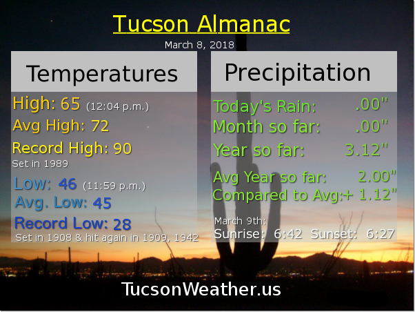
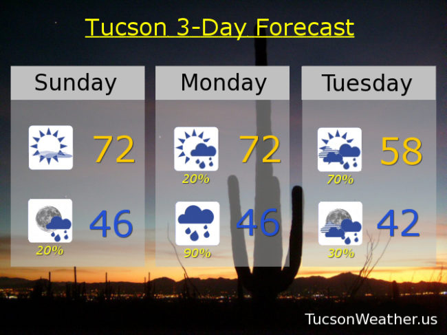
Sunny today and pleasant enough with high clouds streaming through as our storm approacheth. Rain chances start as early as tonight with prime time for the storm being tomorrow night and Tuesday. Could see some thunderstorms thrown in! That would be epic. A disturbance in the force rotating through behind the storm will keep rain chances going through Wednesday. Meanwhile, in the mountains… the National Weather Service has issued a WINTER STORM WATCH above 6,500 feet from 8:00 tomorrow night until 8:00 Tuesday night. So. If you are above 6,500 feet watch for winter weather. Additionally (furthermore) snow levels are likely to drop down to 5,000 feet or so before we are done. We could see several inches of snow there as well. For us? Storm totals could exceed an inch for those lucky enough to get a thunderstorm or two. Otherwise rain totals should be .30″ to .75″ or so. Stay tuned!

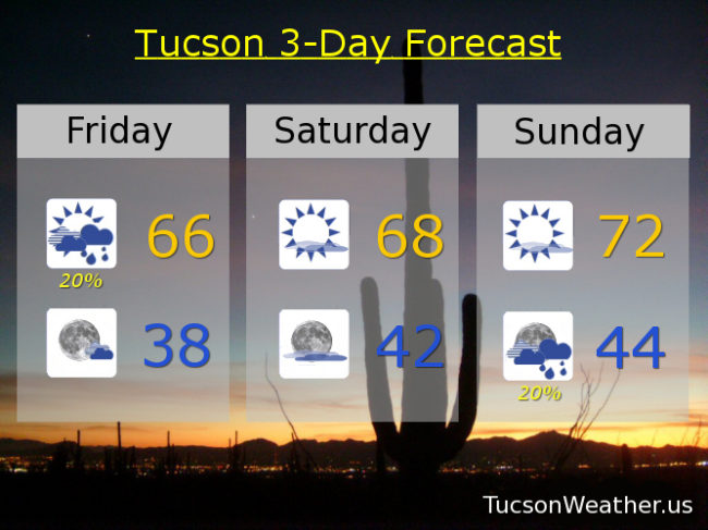
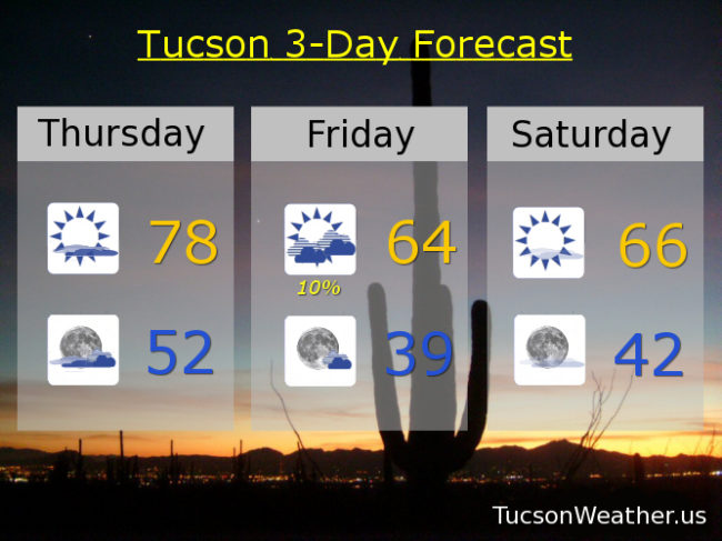
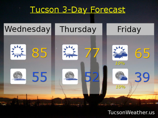
Mostly sunny today with a high in the low 70s. Partly cloudy tonight with a 20% chance for showers and a low in the mid 40s. 20% tomorrow low 70s. 90% chance for showers and possibly a thunderstorm tomorrow night mid 40s. 70% chance for showers and possibly a thunderstorm Tuesday upper 50s. 30% Tuesday night low 40s. 30% Wednesday near 60ish. Sunny Thursday mid 60s. Near 70ish Friday. Low 70s Saturday. Enjoy!

Forecast for Friday, March 8, 2019

Get your red hot cold fronts here! Our first system approacheth. The associated cold front will be blowing through this afternoon. Isolated showers ahead and around the front may be a thing. Not a lot of moisture for it to work with, so not a lot of valley rain and high mountain snow expected. It’ll be breezy with west winds increasing this afternoon.

A break between storms this weekend and cool tomorrow. Pleasant enough Sunday with a high near the average of 72, but it will be breezy as our next storm approacheth. This next storm looks pretty cold and wet. Could see a quarter to a half an inch of rain across the metro. Snow levels will be dropping down to about 5,000 feet with decent snow accumulations of 1 to 2 feet above 7,000 feet! “Several Inches” of snow between 5,000 and 7,000 feet possible. Shower chances start Sunday night and linger all the way into Wednesday evening. Stay tuned!

Partly sunny today with isolated showers possible. Breezy with west winds 10-20 mph gusting to near 30 and a high in the mid 60s. Becoming mostly clear tonight with a low in the upper 30s. Increasing high clouds tomorrow upper 60s. Sunny and breezy Sunday low 70s. 20% Sunday night mid 40s. 40% Monday mid 60s. 60% Monday night low 40s. 50% Tuesday upper 50s. 30% Tuesday night low 40s. 40% Wednesday near 60ish. 20% Wednesday night low 40s. Sunny Thursday low 60s. Enjoy!

Forecast for Thursday, March 7, 2019

We hit 86 yesterday afternoon! Don’t get used to it. The winds of change are blowin’ and it’s fixin’ to cool off with a lot of mountain snow perhaps for next week. I’ll get to that in a sec. First order of business. Good day to fly a kite today… or be a kite! SW winds gusting to near 30 as our next storm approacheth. It’ll bring a chance for showers mainly north of Tucson tomorrow but we may (may) pick up a few hundreths. A break between systems this weekend but on the cool side. Then a good chance for rain and mountain snow to start next week. Early indications are a quarter to three-quarters of an inch of rain for valley locations and 15 to 25 inches of snow above 7,000 feet before it’s all said and done! It’s early, so the National Weather Service will let us know more when we get closer and I will let you know what they let us know, you know? Stay tuned!

Partly sunny today and kinda windy with SW winds 10-20 mph gusting to near 30 and a high in the upper 70s to near 80. Mostly cloudy tonight with a low in the low 50s. 10% chance for isolated showers tomorrow mid 60s. Sunny mid 60s Saturday. Low 70s Sunday. 40% chance for scattered showers Monday mid 60s. 50% Monday night low 40s. 40% Tuesday low 60s. 30% Wednesday mid 60s. Enjoy!

Forecast for Wednesday, March 6, 2019

In a world where the highs are pretty high and lows will get lower. Where storms approach and then do nothing and then do. You’ll be at the edge of your seat because this time, it’s personal…

Or something. 🌝 A few clouds around today for possible sunrise and sunset enhancement, but the big story is the heat. Mid 80s this afternoon! A little bit breezy too to help keep you cool. 😎 Increasing clouds tonight as our first storm approacheth. Breezier tomorrow and a little cooler. Friday’s storm now looking unimpressive but a slight chance for light rain. We will cool off quite a bit this weekend with sunshine behind the exiting storm. Our second storm looks much better if you want the valley rain and the mountain snow. Looks like good news for you Monday into Tuesday. Stay tuned!

Sunny today and a bit breezy with SW winds 10-15 mph and gusty and a high in the mid 80s. Increasing clouds tonight with a low in the mid 50s. Partly sunny and breezy tomorrow with SW winds 10-20 mph and gusty and a high in the upper 70s. 10% chance for showers Friday mid 60s. Sunny mid 60s Saturday. Low 70s Sunday. 30% chance for showers Monday mid 60s. 50% Monday night low 40s. 40% Tuesday low 60s. Enjoy!

Forecast for Tuesday, March 5, 2019

Everyone into the pool! (that would be shockingly refreshing) Heating up today and tomorrow ahead of our next storm. Mid 80s tomorrow? Yep! Windy on Thursday as our storm approacheth with winds gusting to 30 mph ish. I know. Scattered showers mainly Friday afternoon and Friday night. The computer models are saying not as much rain as they first “thought” (can computers “think”?). So a few hundredths to maybe a quarter inch? A few inches of snow in Summerhaven. Sunny but cool this weekend. Then another storm next week. dun dun dunnnnn. This one looks stronger and wetter than the first with scattered showers scheduled to commence on Monday. Stay tuned!

Sunny today with a high in the low 80s. Partly cloudy tonight low 50s. Mostly sunny tomorrow and a bit breezy with WSW winds 10-20 mph mid 80s. Mostly cloudy and kinda windy Thursday with WSW winds 15-20 mph gusting to 30 high in the upper 70s. 30% chance for showers Friday upper 60s. 40% Friday night near 40ish. Sunny Saturday mid 60s. Low 70s Sunday. 30% Monday mid 60s. Enjoy!