Happy Turkey Sandwich Tuesday! You can always make it a twofer and get through those leftovers faster.
Here comes Winter! I stole that from the National Weather Service Forecast Discussion. You should read that everyday. Link below. A couple three storms heading our direction and the computer models agree we have a good chance for valley rain and mountain snow. How low will the snow level go? The answer my friends is still blowing in the wind, but stay tuned.
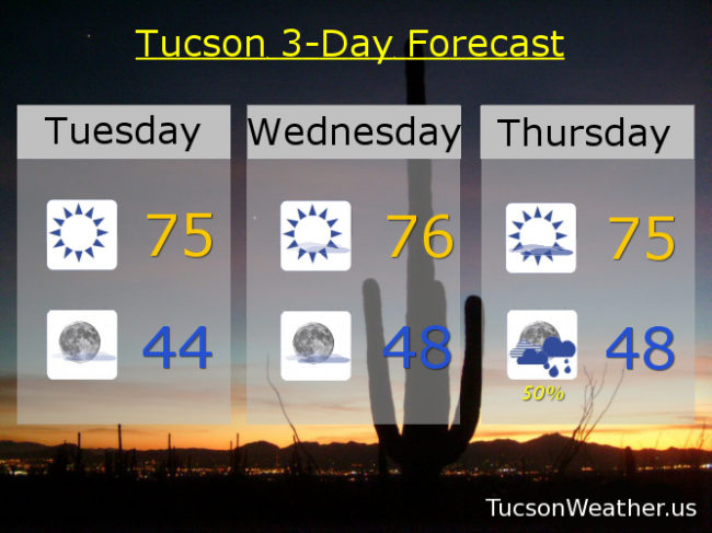
I don’t want to be so future minded that I forget to live in the moment. A bit of high pressure still with us today and tomorrow for warm afternoons after refreshingly cool morning lows. Winds picking up out of the SE Thursday as our first storm approacheth. Good chance for showers Thursday night and mountain snow with snow levels dropping to near 6,500 feet as the storm exits Friday, so probably not enough for sledding… Yet.
Storm number two in here for the tail end of the weekend. It’s colder, which makes sense, because meteorologically speaking Winter starts on December 1st. Highs only in the upper 50s Sunday and Monday with a chance for rain and snow levels perhaps as low as 4,500 feet! Another system following this one? More specifics as we get closer. Again. Stay tuned!
Sunny and nice today and tomorrow with highs in the mid 70s. Low tonight in the mid 40s. Sunny and breezy Thursday with SE winds 5-15 mph and gusty with a high in the mid 70s. 50% chance for showers Thursday night and 20% Friday with a high Friday in the low 60s. Mostly sunny Saturday mid 60s. 30% chance for showers Sunday and 10% Monday upper 50s. Enjoy!
Tucson National Weather Service Forecast Discussion: https://forecast.weather.gov/product.php?site=TWC&issuedby=TWC&product=AFD&format=CI&version=1&glossary=1