Get your red hot cold fronts here! A cold system is moving onshore in California even as I type. It will make steady progress our way throughout the day with SE breezes and high cloudiness ahead of it. Hopefully we’ll manage some sunrise and sunset enhancement! The storm moves through tonight dragging a strong cold front through the area late tonight into tomorrow morning. Showers and mountain snow along and behind the front with 3″-5″ inches possible for Summerhaven. A disturbance in the force riding through tomorrow should give us another round of showers and mountain snow during the day. Summerhaven could pick up another inch. A break in the action but cool Saturday with plenty of clouds around. Another disturbance moving through Saturday night and Sunday with another round of rain and mountain snow. Snow levels down to 5,500 feet or lower. The whole thing moves out Monday and we start a warming trend. Then all eyes are on Thursday/Friday of next week. Still a ways away, but it looks like a strong, cold storm could be headed our way. It could be what we call, a doozy! Stay tuned!
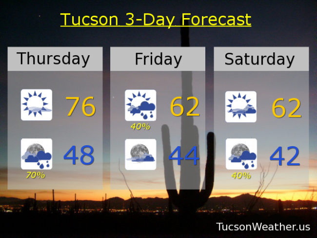
Mostly sunny and breezy today with SE breezes 10-20 mph and gusty with a high in the mid 70s. Showers likely tonight (70%) with a low in the upper 40s. 40% chance for showers tomorrow with a high in the low 60s. Partly sunny Saturday low 60s. 40% chance for showers Saturday night and Sunday. Sunday’s high in the upper 50s. Sunny Monday near 58ish. Mid 60s Tuesday. Upper 60s Wednesday. Enjoy!