Monthly Archives: December 2018

Forecast for Wednesday, December 26, 2018

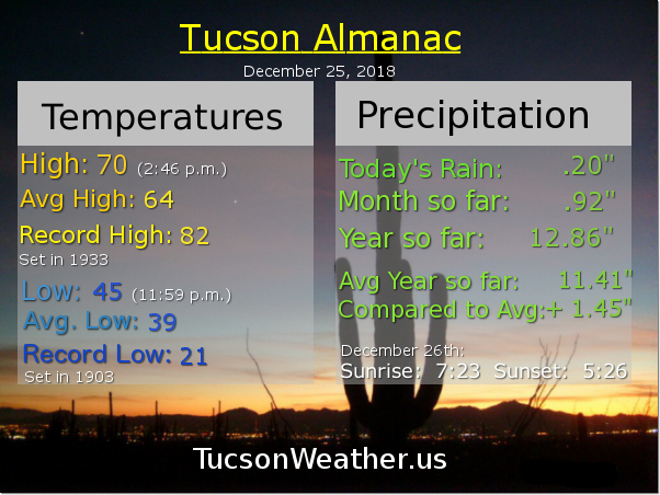
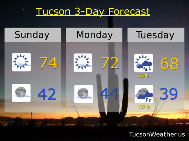
The road to Summerhaven is closed this morning but looking at the Simply Bits cameras it looks like they only got maybe 4″-6″ inches of snow? .20 inches of rain at the airport with a few lingering showers possible still this morning. We’ll take it! Moving forward the biggest weather headline is the COLD. Another system in here by tomorrow night with snow levels down to 3,500 feet perhaps. Snow in Saddlebrook? Catalina? Maybe. For sure it will be cold behind the storm. Saturday and Sunday mornings in the upper 20s, so make sure your outside plants put on their Winter coats. It’ll stay on the cool side the rest of the year. The bad news is the computer models have cancelled the storm for New Year’s Day. Stay tuned for any changes, because, you know. It’s the weather!

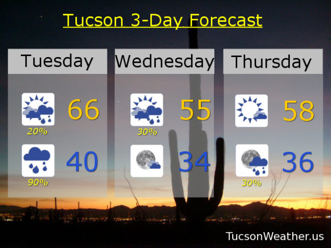
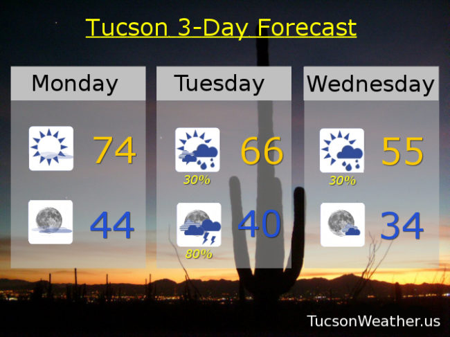
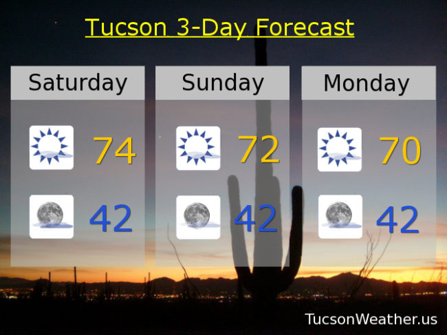
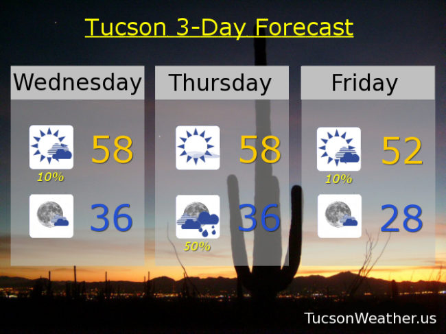
Becoming mostly sunny this afternoon after a chance for lingering showers this morning and a high in the upper 50s. Partly cloudy tonight mid 30s. Mostly sunny tomorrow upper 50s. 50% tomorrow night mid 30s. 10% Friday low 50s. Sunny Saturday low 50s. Mostly sunny Sunday low 50s. Upper 50s Monday and New Years Day.

Forecast for Tuesday, December 25, 2018

Merry Christmas! I hope all of your dreams are coming true 🙂

I’m liking this forecast. LOTS of snow in them there hills expected. A WINTER WEATHER ADVISORY is in effect from 5pm today until 5pm tomorrow. The official forecast for Summerhaven states: total daytime (today) accumulation of 1 to 2 inches possible. New snow accumulation (tonight) 6 to 10 inches possible. Shut the front the door!!! Amazing. Maybe I’ll head that way this afternoon. For us valley dwellers the wind has already started to pick up as our storm approacheth. Showers should be developing this afternoon with rain and thunderstorms a good bet for tonight. Some spots could get a half inch of rain. Most will top out near a third of an inch. And. Some folks might not get much at all. (sorry about that chief) Lingering showers tomorrow and a break on Thursday. Then another storm in here for Thursday night/Friday. Will it snow down to the valley floor? Maybe. It WILL be cold. Upper 20s expected Saturday and Sunday mornings. You might want to let the teenagers actually sleep inside this weekend. Stay tuned!

Partly sunny today with a 20% chance for afternoon showers and a high in the mid 60s. SW winds gusting to near 30 mph. Showers and possibly a thunderstorm tonight with a low near 40ish. Scattered showers tomorrow mid 50s. Mostly sunny Thursday upper 50s. 30% Thursday night mid 30s. 20% Friday low 50s. Mostly sunny Saturday mid 50s. Sunny Sunday upper 50s. Mostly sunny Monday upper 50s. Enjoy!

Forecast for Monday, December 24, 2018

’twas the day before Christmas and all through the house. Not a creature was stirring including my ex spouse! (I mean, she moved and stuff so… ) The weather was warm with plenty of Sun. But changes were coming before Christmas was done! Increasing clouds and increasing wind. Rain and mountain snow in the afternoon will begin. Five to seven inches in Summerhaven maybe. Up to half inch of rain in the Metro baby! Showers and storms will leave us on Wednesday. But more cold weather still headed our way. Will it snow in Tucson? We still don’t know. Winter has arrived! Santa and at least mountain snow. Merry Christmas!

Sunny today mid 70s. Mostly clear tonight mid 40s. 30% chance for showers tomorrow afternoon mid 60s. 80% tomorrow night with snow levels dropping to near 5,000 feet. Summerhaven expecting 5-7 inches of snow. Showers and possibly a storm in the metro mid 40s. 30% Wednesday mid 50s. Mostly sunny upper 50s Thursday. 20% Friday low 50s. 10% Friday night 32ish. 10% Saturday mid 50s. Mostly sunny Sunday upper 50s.

Forecast for Sunday, December 23, 2018

You better not pout. You better not cry. You better not whine. I’m telling you why. Rain and snow is coming to town! You read (sang) that right. Rain AND snow is coming. To town! It’s what I was alluding to during yesterday’s FB Live. These storms this week will be cold and colder. So. Maybe some snow down to the valley floor before the week is over! Not expecting a lot to stick or anything like that, but the word snow is in the official forecast. I’m pretty pumped about it.

But. First things first. Our beautiful four day (for most) weekend continues with lots of sunshine and warm temperatures. Some high cloudiness for hopefully more sunrise and sunset enhancement. Then our Christmas storm blows in.

It’ll be breezy/windy ahead of the cold front and a chance for a few showers Christmas afternoon. The front blows through Christmas evening and that’s when the fun really begins. Scattered showers and thunderstorms Tuesday night into Wednesday morning. Could see .2 – .4″ of rain in valley locations. Snow begins above 7,000 feet Christmas afternoon and the snow level drops to near 5,000 feet Wednesday morning. The official forecast for Summerhaven is for less than half an inch of snow Christmas afternoon and 2-4″ Tuesday night. Could see up to 7″ at Ski Valley.

A break in the action Thursday but cool. Next chance of rain in here by Thursday night into Saturday with a chance for rain AND snow showers Friday night and Saturday morning. Stay tuned!

Mostly sunny today mid 70s. Low 70s tomorrow. Breezy Christmas with a 30% chance for showers. SE wind 10-20 mph and gusty becoming WSW in the afternoon and a high in the upper 60s. 60% chance for showers and storms Tuesday night upper 30s. 20% Wednesday mid 50s. Mostly sunny Thursday upper 50s. 20% Thursday night and Friday mid 50s. 20% chance for rain and snow showers Friday night near freezing. Slight chance for rain and snow showers Saturday morning low 50s. Enjoy!

Forecast for Saturday, December 22, 2108

More sunshine today as the considerable high cloudiness will be much less considerable. Clearing is happening from the west even as I type. Sun shining through this weekend even as our Christmas storm approacheth. Our Christmas cold front won’t blow through until evening but a chance for showers ahead of it during the afternoon feast. Snow in the mountains starting at around 7,000 feet. That crashes below 5,000 feet Christmas night and Wednesday morning as the chance for showers increases. Still, valley locations only expecting a quarter inch or less from the storm. “Things” stay unsettled Wednesday and Thursday. Our next storm moves in Thursday night into Friday. Not looking like a lot of moisture with this storm either, but it does look colder. Stay tuned!

Mostly sunny today with a high in the mid 70s. low 70s tomorrow. Near 70ish Monday. 30% chance for showers Christmas afternoon mid 60s. 60% Tuesday night upper 30s. 20% Wednesday mid 50s. Mostly sunny Thursday mid 50s. 20% Thursday night and Friday low 50s.