You better not pout. You better not cry. You better not whine. I’m telling you why. Rain and snow is coming to town! You read (sang) that right. Rain AND snow is coming. To town! It’s what I was alluding to during yesterday’s FB Live. These storms this week will be cold and colder. So. Maybe some snow down to the valley floor before the week is over! Not expecting a lot to stick or anything like that, but the word snow is in the official forecast. I’m pretty pumped about it.
But. First things first. Our beautiful four day (for most) weekend continues with lots of sunshine and warm temperatures. Some high cloudiness for hopefully more sunrise and sunset enhancement. Then our Christmas storm blows in.
It’ll be breezy/windy ahead of the cold front and a chance for a few showers Christmas afternoon. The front blows through Christmas evening and that’s when the fun really begins. Scattered showers and thunderstorms Tuesday night into Wednesday morning. Could see .2 – .4″ of rain in valley locations. Snow begins above 7,000 feet Christmas afternoon and the snow level drops to near 5,000 feet Wednesday morning. The official forecast for Summerhaven is for less than half an inch of snow Christmas afternoon and 2-4″ Tuesday night. Could see up to 7″ at Ski Valley.
A break in the action Thursday but cool. Next chance of rain in here by Thursday night into Saturday with a chance for rain AND snow showers Friday night and Saturday morning. Stay tuned!
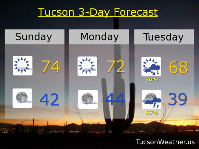
Mostly sunny today mid 70s. Low 70s tomorrow. Breezy Christmas with a 30% chance for showers. SE wind 10-20 mph and gusty becoming WSW in the afternoon and a high in the upper 60s. 60% chance for showers and storms Tuesday night upper 30s. 20% Wednesday mid 50s. Mostly sunny Thursday upper 50s. 20% Thursday night and Friday mid 50s. 20% chance for rain and snow showers Friday night near freezing. Slight chance for rain and snow showers Saturday morning low 50s. Enjoy!