Monthly Archives: December 2018

Forecast for Friday, December 21, 2018

It’s Friiidaaay!!!

It’s also the Winter Solstice that hits at 3:23 this afternoon. The Sun will be directly over the Tropic of Capricorn. For just a moment you might feel dizzy. Dogs will probably start barking. If you are doing the dishes you might break one. Actually I made all of that up, but it will be the farthest south the Sun will travel and it will now start slowly making the long journey back to the Northern Hemisphere.

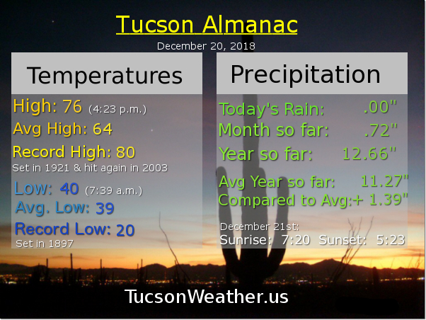
Now that that’s out of the way, where were we? Oh yeah. Warm again today! It would be warmer but an increase in high clouds will help keep us from the record of 80 set in 1917. Possible sunrise and sunset enhancement through the weekend as high clouds from time to time will be hangin’ around. The big changes come Christmas Day. A pretty cold cold front will be blowing through along with a storm system. We are still a few days away (sorry kids) so the timing and strength is still “up in the air” (see what I did there?), but it’s looking like at least a chance for rain by Christmas afternoon with snow in the mountains. Snow level could drop close to 4,000 feet with this one by Wednesday morning! Possibly (probably) another storm behind that one keeping us in valley rain and mountain snow chances through much of the week. Stay tuned!

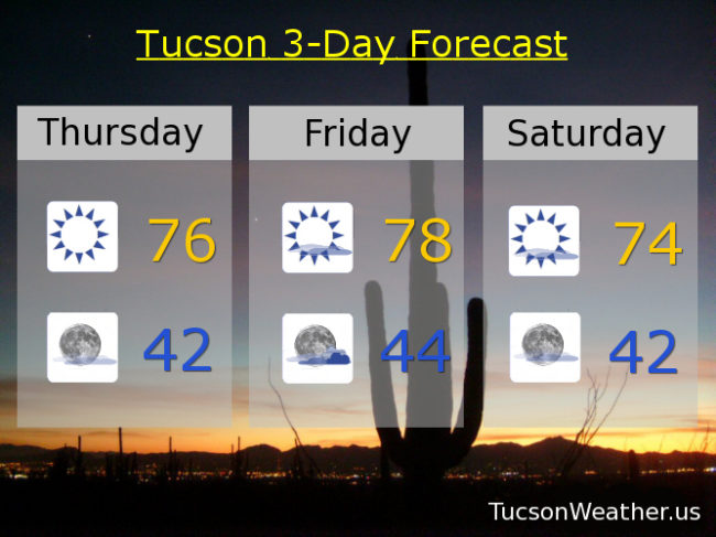
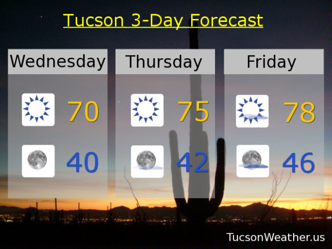
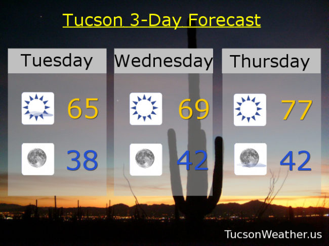
Mostly sunny today near 77. Mostly cloudy tonight mid 40s. Sunny tomorrow mid 70s. Low 70s Sunday. Near 70ish Monday. 10% chance for showers Christmas Day mid 60s. 50% Tuesday night mid 30s. 20% Wednesday mid 50s. 10% Thursday upper 50s. Enjoy!

Forecast for Thursday, December 20, 2018

Our old pal high pressure has returned and he is bringing gifts! Sunshine and warmth for all the good boys and girls of southern Arizona. Be sure and thank him by heading to the park or tormenting your friends and family in colder climes. Make hay while the sun shines! He can’t stick around too long. Sunny days in the 70s in December. There are worse things. A series of weak storms will be moving through through the weekend. No real threat for rain or mountain snow, but they will knock some sense into our temperatures. Even then, still on the warm side for this time of year. Also some high cloudiness for possible sunrise and sunset enhancement. That is always nice. Then a series of stronger and colder storms will bring a chance for rain and mountain snow starting Christmas night and continuing through next week. Stay tuned!

Sunny and warm today with a high near 76ish. Mostly clear tonight low 40s. Mostly sunny tomorrow with a high in the upper 70s (the record is 80. Let’s not and say we did). Sunny Saturday mid 70s. Sunny Sunday low 70s. Near 70ish Monday. Mostly sunny upper 60s Christmas Day. 20% chance for showers Christmas night mid 30s. 20% Wednesday upper 50s. Enjoy!

Forecast for Wednesday, December 19, 2018

Still on track for a quick warm up through the end of the week. The 70s return today! Que up Ambrosia, “And I keep ho o o o o o ld iiing o o o n to yesterday…” A few high clouds start to increase by Friday as our next couple of weak storms approacheth. No rain or mountain snow expected but these weak systems will slam on the brakes to our sudden warming trend. A couple of stronger storms set to change the weather pattern just in time for Christmas. Valley rain and mountain snow are looking like a decent bet next week. Place your orders and stay tuned!

Sunny today with a high near 70ish. Clear skies tonight with a low near 40ish. Sunny mid 70s tomorrow. Upper 70s Friday. Mostly sunny mid 70s Saturday. Sunny 70 Sunday (say that 5 times fast) (“that 5 times fast”) (smart alec). Sunny 70 Monday. 10% chance for showers Christmas Day mid 60s.

Forecast for Tuesday, December 18, 2018

Our exiting storm system is exiting to the east leaving us with mostly clear skies in it’s wake. A bit of coolness in the air as well with lows tomorrow morning back in the 30s! Then high pressure building back in and we will warm up rather quickly, especially Thursday, with highs in the upper 70s by the end of the week. Everyone into the pool! (Wait. Not everyone is a member of the Polar Bear Club) Record highs for Thursday and Friday are both 80. We’ll be getting close if the forecast comes exactly true (hey, it could happen). Then it’s a series of systems that will cool us off just in time for Christmas. It should stay dry, but it looks like one around Friday. Another late Saturday into Sunday. Then another Monday. Perhaps (possibly. it’s a long ways out still) a stronger storm with rain and mountain snow late Christmas into Thursday of next week. Stay tuned!

Sunny today and cooler with a high in the mid 60s. Chilly tonight (mmm chili) with a low in the upper 30s. Sunny tomorrow upper 60s. Upper 70s Thursday. Mostly sunny Friday upper 70s. Mid 70s Saturday. Sunny low 70s Sunday. Upper 60s Monday.

Forecast for Monday, December 17, 2018

Our first system that brought the clouds and a few sprinkles yesterday has moved on. Another system will be missing us to the NE today. So. We’ll get cooler before we get warmer. Mostly sunny today upper 60s. Partly cloudy tonight near 40ish. Sunny mid 60s tomorrow. Then our old pal high pressure moves in bringin’ the warmth. 70 Wednesday. Upper 70s Thursday and Friday. Low 70s Saturday and Sunday. Enjoy!