Monthly Archives: February 2020

Forecast for Monday, February 24, 2020

Looks like the robots are indicating a cold and wet storm next week. It is a ways away so consider it a hint of things to come. A foreshadow of what might be. In the meantime we have to suffer through some warm Winter weather. It’s not easy being the envy of the rest of the country. (or being cheesy) The struggle is real. Here are the future numbers and we’ll see what reality brings.

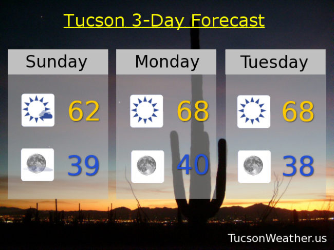
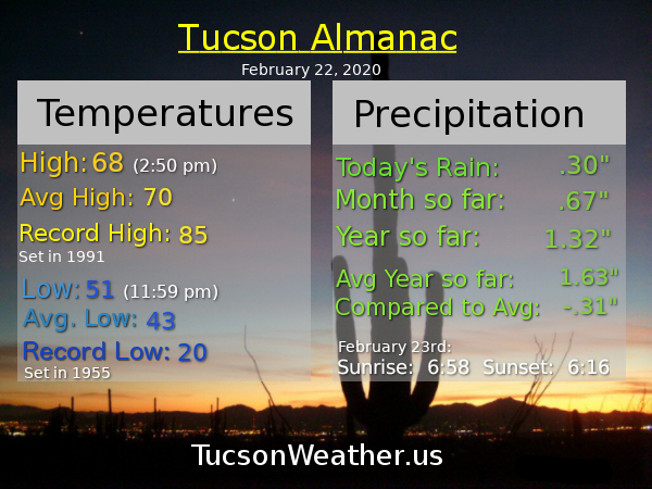
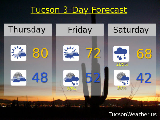
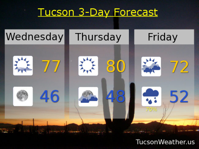
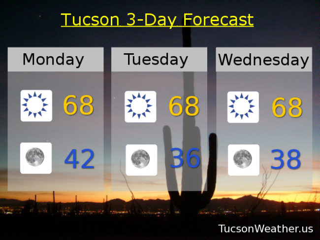
Sunny and warmer today upper 60s. (yesterday was 59) Low 40s tonight. Upper 60s tomorrow and Wednesday. Warmer still as we head into the weekend. Mid 70s Thursday. Upper 70s Friday. Near 80ish Saturday! Mid 70s Sunday. Enjoy and stay tuned!

Forecast for Sunday, February 23, 2020

Cue the Supremes, “You Just Keep Me Hangin’ On”. A few lingering showers this morning otherwise our storm has exited stage east. (Heavens to Murgatroyd) By the time we get to this afternoon the Sun will be smilin’ with a high in the low 60s. Mostly clear and chilly tonight (mmm chili) upper 30s. Sunny upper 60s tomorrow, Tuesday, and Wednesday. Mid 70s Thursday. Upper 70s Friday and Saturday!!! Enjoy 🙂

Forecast for Saturday, February 22, 2020

Think it’ll rain? No worries. Just Scotch Guard the kids! Tropical moisture streaming northward into the area ahead of a cold front is bringing widespread rain with everyone (pretty much) getting in on the action this morning. By this afternoon the current blob (technical jargon for ya on a Saturday) of rain will move north and east. As the front moves through this afternoon we should see another round of copious showers with embedded thunderstorms. Some of the storms could have locally heavy rain and even strong winds. With this mornings rain combined with locally heavy rain this afternoon we could see local flooding. Finally a chance to kayak the Rillito! Maybe. (disclaimer. it was a joke. never kayak the Rillito) Rain lingers into tonight finally decreasing after midnight. High today in the low 60s. Low tonight in the low 40s.

The Sun returns tomorrow with a high in the low 60s. Upper 60s Monday, Tuesday, and Wednesday. Mid 70s Thursday. Upper 70s Friday. Enjoy!

Forecast for Thursday, February 20, 2020

Happy Friday Eve! It makes the weekend seem closer…

There’s a storm brewin’! (coffee maybe?), and it’s headed our way. Prime time looks to be Saturday morning. Wind, rain, and even some thunderstorms possible with this one. Suspected rainfall amounts have been adjusted higher by the robots (computer models) once again! Valley locations could see a quarter to three quarters of an inch of rain with isolated amounts over an inch. Bring it! The mountains should get more, but we are talking rain and not snow. Could be fun! Here’s the best guesstimation of the future (echo; future future future)

Increasing clouds and breezy today. High near 80ish! Mostly cloudy tonight upper 40s. Mostly cloudy and windy tomorrow with ESE winds 15-25 mph gusting over 35 and a high in the low 70s. The rain chances commence tomorrow night with the best chances toward morning into Saturday. 100% chance for rain Saturday with a few thunderstorms thrown in for good measure and a high in the upper 60s. Lingering showers Saturday night with clear skies by Sunday. Sunny Sunday low 60s. Upper 60s Monday. Near 70ish Tuesday. Low 70s Wednesday. Enjoy!

Forecast for Wednesday, February 19, 2020

Mike Mike Mike Mike Mike. What day is it Mike? It’s the day before the first 80 degree day of the year! You know. Unless today over performs and calls the weatherman a liar. In any event this mornings considerable high cloudiness will gradually yield to clear skies and tons of sunshine this afternoon and a high in the upper 70s. Clear tonight mid 40s. Sunny tomorrow near 80ish!

Our next storm approacheth and the robots (computer models) are predicting an increase of moisture from previous runs. Also warmer, meaning the snow levels will be way up there. Now expecting anywhere from a tenth of an inch of rain to half an inch in the valley with some places perhaps getting three-quarters of an inch. Hopefully you! We’ll go with increasing clouds tomorrow night. Mostly cloudy Friday and breezy (sorry about that) low 70s. Showers likely Friday night and Saturday with a high Saturday in the upper 60s. Sunny Sunday mid 60s, Low 70s Monday. Mid 60s Tuesday. Enjoy!