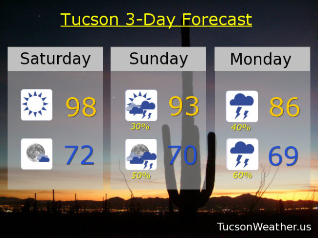
Very refreshing on the patio/deck/roof this morning. Currently 70 at 5:35. Nice! High pressure remains parked over our head for another day with a high today near 98.
The times they are a changin’! A gift from the tropical waters off the Mexican Coast, Hurricane Rosa is making a beeline for SW AZ. Clouds and moisture on the increase through the day tomorrow with a good chance for showers and storms by afternoon/evening. High in the low 90s.
Monday looking cloudy and rainy with embedded thunderstorms, some with locally heavy rainfall, and a high in the mid 80s. The main event should be Monday night into Tuesday as the much weakened circulation from Rosa moves just to the west and then north of Tucson. Numerous showers and storms Monday night and Tuesday along with increasing breezes. Could be fairly windy in the mountains! Monday’s high in the mid 80s. 50% chance for rain Tuesday mid 80s. There is a FLASH FLOOD WATCH in effect for central Pima County and Pinal County Monday morning through late Tuesday night. If Rosa’s path should move just a bit more to the east then forecast, the watch may be updated to include the Metro. Stay tuned.
A trough of low pressure moves through the state Wednesday bringing a slight chance for showers as it moves through. Continued cooler than average to start October. 20% chance for showers Wednesday mid 80s. 10% Thursday mid 80s. Sunny Friday mid 80s. Enjoy!