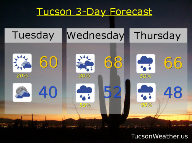
A major Winter storm is forming and will be making a Thanksgiving visit. Always nice to have guests drop by for a festive feast! It’s a cold storm and the main headline will be the massive snow totals above 7,000 feet. Could see 3 feet of snow at Ski Valley!!! Winds gusting 50 to 60 mph in the high country could lead to white out conditions at times. Not to mention falling trees to go with their sideways snow. If it weren’t for Rudolph, Thanksgiving might be cancelled. (sorry. I got ahead of myself there) Honorable mention weather headline goes to Cochise County. Lots of moisture being pulled northward ahead of the system. A cold front approacheth and should move through today. The combination could bring heavy rain east of Tucson. Just be aware if you are heading that way. Today’s aforementioned front will chill us out a bit in Tucson with a high about 10 degrees cooler than yesterday. A few showers out there this morning that should end by 8:00 a.m., so there’s that.
Increasing clouds tonight with a low near 40ish.
Mostly cloudy with a few showers around tomorrow upper 60s. Cloudy tomorrow night and Thanksgiving with a 50% chance for rain. Thursday’s high in the mid 60s.
Prime time for our storm should be Thursday night into Friday morning. A WINTER STORM WATCH for Summerhaven starting at 6:00 p.m. Thursday until Midnight Friday night. Summerhaven could see half a foot to a foot of snow along with those 50-60 mph winds.
Looks like a good soaking for us lowlanders. Blustery Thursday night and Friday with rain, heavy at times, possible. Valley locations looking for an inch to an inch and a half of rain. Amazon Prime is looking good for Black Friday! Nothing like shopping in the comfort of your own home while others hydroplane to Best Buy for that 75″ TV on sale for $400. (wait. Is that a thing?) Friday’s high in the upper 50s.
The rain will mainly be on the wane Saturday becoming mostly sunny with a high in the upper 50s. A slow warming trend Sunday and Monday with sunshine and highs mid to upper 60s respectively. Stay tuned. We’ll keep you updated as the storm gets closer. What else do I have to do at 5:00 in the morning? 🙂