‘Twas the day before Thanksgiving and all through the store, people were shopping for turkeys and more. The guest rooms prepared and beds made with care. All in anticipation of in-laws staying there. The cranberry sauce in the can is the worst. Seriously, I’d much rather have bratwurst! The rhythm of the rain will exceed the cadence of this poem. Heavy at times and maybe a storm. Winter has arrived in time for Thanksgiving! If you like weather it’s a great time for living.
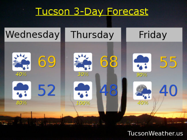
It’s a tale of two storms. Heavy rain and massive mountain snow still expected. Lots of wind as well. If you have hatches, batten them down! One change in the forecast is mainly for today. An upper level low off the Baja California coast is pulling moisture northward. Originally the thinking was that mainly Cochise County would get in on this initial action. It appears now that Tucson may be included. Look for a decent chance for rain today with increasing clouds and a high in the upper 60s.
A better chance for rain tonight with a low in the low 50s.
A bit of a break tomorrow as our second storm appraocheth. Still a few showers around in the morning with mostly cloudy skies all day. Breezes picking up as well gusting to around 25 mph and a high in the upper 60s.
Prime time for our Winter storm is Thanksgiving night into Friday. A FLASH FLOOD WATCH is in effect from 11:00 a.m. Thanksgiving until 5:00 p.m. Friday. Rain, heavy at times, possibly a few thunderstorms, and windy. Winds gusting to near 40 mph. A WIND ADVISORY is in effect from 11:00 p.m. Thursday until 2:00 Friday afternoon. Friday’s high in Tucson a rain soaked 55ish.
The mountains will be hit hard with this storm. Heavy rain changes to heavy snow in Summerhaven Thanksgiving evening and it will be coming down! A FLASH FLOOD WATCH, WINTER STORM WARNING, and WIND ADVISORY all in effect from various times starting tomorrow into Friday. Winds could gust to 55 mph with 15″ to 25″ of snow expected in Summerhaven! Could see 3 feet at Ski Valley!!!
The storm starts to move out Friday night with lingering showers. Clearing out Saturday and cool with a high in the upper 50s. Sunny Sunday upper 60s. Low 70s Monday and Tuesday. Perhaps another storm late next week! But we’ll burn that bridge when we get to it. Stay tuned!