Happy Thanksgiving! I can smell your roasting turkey from here. Amazing! Is it irony or coincidence that turkeys go “gobble gobble gobble”? What time is dinner? 🙂
Our Winter storm approacheth with wind and rain and literally tons of mountain snow. (seriously. If you weigh all the snow it will easily weigh tons) The associated cold front with our approaching storm is currently in western Arizona. It will hang out there through this afternoon before heading east and moving through these parts tonight. Winds and rain chances will increase as it gets closer and moves through. Snow levels are currently around 8,000 feet. Those will slowly sink to 7,000 feet and then down to 5,000 feet by tomorrow morning. 6 inches of snow or so possible above 6,000 feet. 1 to 2 feet perhaps above 7,000. Could see 3 feet or more at Ski Valley! Just epic if it comes true. For Summerhaven a FLASH FLOOD WATCH is in effect from 5:00 tonight until 5:00 tomorrow night. A WIND ADVISORY begins at 11:00 tonight and ends at 2:00 tomorrow afternoon. Be advised, it’s gonna be windy with winds gusting to 60 mph to blow that heavy snow around! A WINTER STORM WARNING is in effect from 11:00 tonight until Noon tomorrow. If I could afford a cabin up there I’d head up today, start a fire in the fireplace, and enjoy the show!
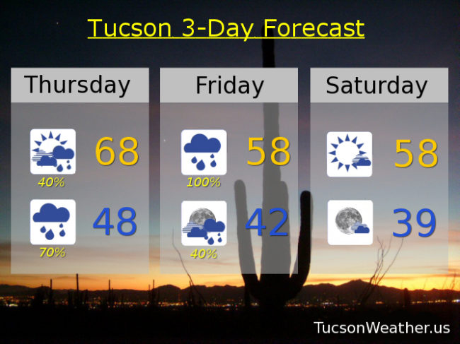
This is Tucson Weather, so let’s go over the 411 for the Old Pueblo. A 40% chance for showers this morning otherwise mostly cloudy today with a high in the upper 60s.
A FLASH FLOOD WATCH begins tonight at 11:00 and lasts until 5:00 p.m. tomorrow. Cloudy tonight with showers likely. A WIND ADVISORY from 11:00 p.m. tonight until 2:00 tomorrow afternoon. Winds tonight out of the south 25-35 mph gusting to 50! Low in the upper 40s.
Heavy rain possible with wind tomorrow. In other words, quite blustery! WSW winds 20-25 mph gusting over 35. The rain should start to taper off by afternoon but still breezy with showers about. High in the upper 50s.
Scattered showers Friday night before midnight becoming partly cloudy by Saturday morning. The Sun returns Saturday with a few clouds and a high in the upper 50s. Sunny Sunday 68ish. Partly sunny Sunday and Monday low 70s. Scattered showers Wednesday as our next storm moves in! High in the upper 60s. Enjoy!