Monthly Archives: October 2017

Forecast for Saturday, October 21, 2017

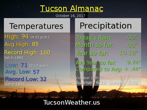
The cooler air has arrived and today will be downright pleasant! Tomorrow morning will be somewhat chilly (mmm chili) as lows dip into the 40s for some in the metro. Don’t get used to it. High pressure re-exerting itself will mean near record highs to start the work week. Some cooling by the end of the week into next weekend, but still above average.

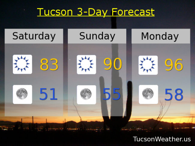
Sunny today with a high near the seasonal average of 83.

Clear and cool tonight with a low near 51.

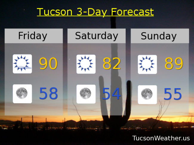
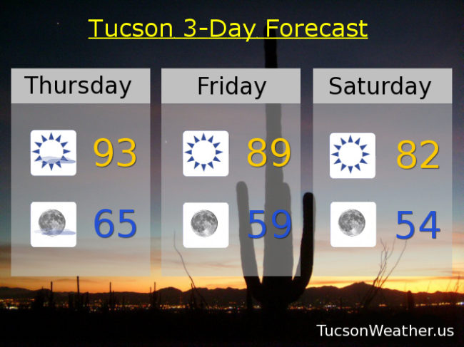
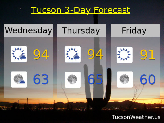
Sunny and warmer tomorrow with a high near 90ish. 96 Monday (record is 94). 96 Tuesday (record is 96). 94 Wednesday (record is 95). Low 90s Thursday. Mid 80s Friday.

Forecast for Friday, October 20, 2017

It’s Friiiiidaaay!!!

Some relief from the heat the next couple three days and then it’s back in the October oven. A system to our north will push our obnoxious high out of the area briefly making for a decent weekend. Tomorrow looks especially nice. Then it’s like a bad Halloween movie where the villain just won’t die. High pressure returns next week to turn up the heat. Near record highs with relentlessly sunny skies. It will cool off for good… eventually. 🙂

Mostly sunny today and a bit breezy with SW winds 5-15 mph gusting over 25 and a high near 90.

Clear skies tonight with winds relaxing. Perfect conditions for enjoying the Orionid Meteor Shower that peaks after midnight! Low near 58.

Sunny and cooler tomorrow with a high actually near the average of 83 with an expected high near 82!

Sunny Sunday near 90. 94 Monday. 96 Tuesday (record is 96). 93 Wednesday. 90ish Thursday.

Forecast for Thursday, October 19, 2017

A weak system moving through the state will give us just a few degrees of cooling today (we’ll take it!) and a few clouds. Otherwise another very warm October day. A system missing us to the north will bring breezes and more cooling tomorrow and Saturday. Saturday’s forecast high is actually a degree or two below average for this time of year! Don’t get used to it. Near record high settles back in early next week with high pressure large and in charge. Stay tuned.

Mostly sunny today with a high near 93.

Mostly clear tonight with a low near 65.

Sunny and a little bit breezy tomorrow with a high near 90. Low 80s Saturday! Near 90 Sunday. Mid 90s Monday, Tuesday and Wednesday.

Tucson International Airport
Forecast / Record
Mon, Oct 23:  95 / 94
Tue, Oct 24:  96 / 96
Wed, Oct 25:  94 / 95

Forecast for Wednesday, October 18, 2017

The forecast stays the same before it gets better before it gets worser. Clouds from a disturbance in Mexico will start to clear today with our highs remaining in the mid 90s today and tomorrow. A storm system missing us to the north will cool us off almost to near average for this time of year by Saturday. Enjoy it because high pressure builds in with a vengeance next week. The National Weather Service says that Tuesday’s expected high of 97 would be the second latest occurrence of 97 in a calendar year with the latest being 97 on October 27th of last year. IF we hit 98 that would be the latest occurrence of 98 in a calendar year. The record high for Tuesday is 96 set in 1959. Lets try to avoid breaking it if that is OK with you 🙂 Stay tuned!

Becoming mostly sunny today with a high near 94.

Mostly clear tonight with a low in the low 60s.

Mostly sunny tomorrow with a high near 94. Sunny Friday low 90s. Mid 80s Saturday! Near 90 Sunday. Mid 90s Monday. Upper 90s Tuesday.

Forecast for Tuesday, October 17, 2017

Make it stop! Mid October and it’s still in the 90s. Some interesting things going on with the forecast however. For example, high clouds streaming our way from the south will give us filtered sunshine today and possible sunset enhancement this evening. That’s always fun! Still hot though. Slightly cooler tomorrow and Wednesday as a weak disturbance moves through the state. Slight chance for a few showers to our north and northeast, but maybe. Another system to our north will bring us some cooling for the weekend with highs in the 80s to near 90. Unfortunately high pressure builds back in and we heat back up next week. Stay tuned!

Some high cloudiness today with a high near 95.

Partly cloudy tonight with a low in the low 60s.

Mostly sunny tomorrow and Thursday with highs in the low 90s. Near 91 Friday. Upper 80s Saturday. Near 90 Sunday. Mid 90s Monday.