
Monthly Archives: November 2017
Forecast for Sunday, November 19, 2017
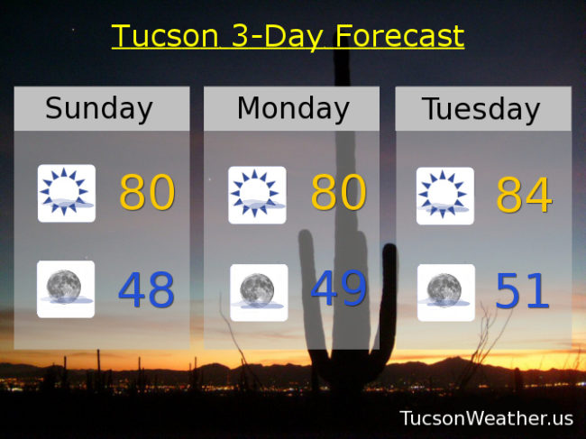
Stop me if you’ve heard this one before. High pressure building back in for a warming trend through Thanksgiving. Pretty nice today and tomorrow with highs near 80, but that is still about 8 degrees above average for this time of year. Mid 80s tomorrow. Upper 80s Wednesday, Thanksgiving and Friday which could be records. Mid 80s Saturday. High clouds from time to time for possible sunrise and sunset enhancement.
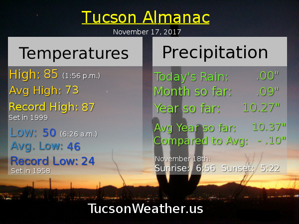
Almanac for Saturday, November 18, 2017

Forecast for Saturday, November 18, 2017
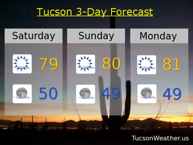
A cool front moving through today will knock our temperatures back about 6 degrees from yesterday’s high of 85. Very pleasant this weekend with highs in the upper 70s to near 80. Still well above the low 70s average for this time of year. A few high clouds from time to time for possible sunrise and sunset enhancement, so there’s that! High pressure building back in next week with near record highs for Thanksgiving and Thanksgiving weekend.
Mostly sunny today with a high near 79.
Mostly clear skies tonight with a low near 50.
Mostly sunny tomorrow near 80. low 80s Monday and Tuesday. Mid 80s Wednesday, Thursday and Friday. Records for Thursday and Friday are 87 and 86 respectively.
Almanac for Friday, November 17, 2017
Forecast for Friday, November 17, 2017
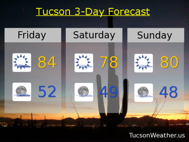
It’s Friiidaaay!
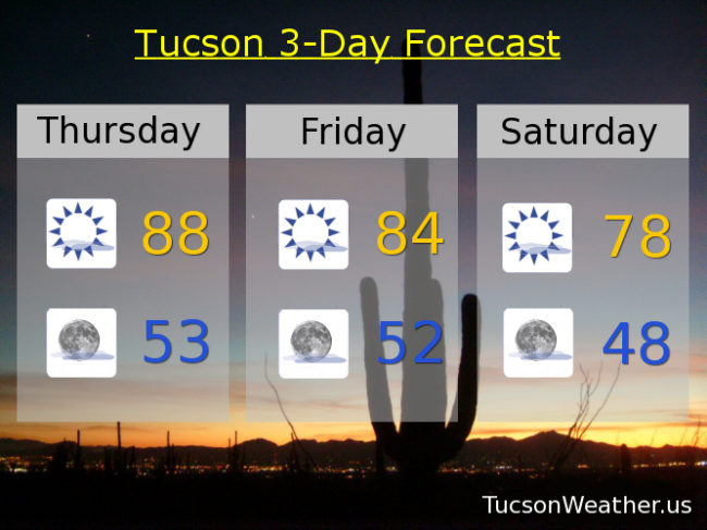
Another record yesterday. We tied the record high of 89. The good news is we didn’t hit 90 and haven’t this month! It’s a psychological victory, but I’ll take it. The other good news is we are fixin’ to cool off quite a bit this weekend. True, we’ll still be 5 or more degrees above average, but much cooler than it’s been. High clouds increasing today and not as warm with a high near 84. As a strong storm to our north moves east we’ll see even cooler air move in this weekend with highs tomorrow in the upper 70s! Nice. Near 80 on Sunday. Monday and Tuesday look very nice with highs near 80 as well. Then high pressure begins to nose back in and we could see record or near record highs for Thanksgiving. Wednesday’s high near 84ish and 85ish for Thanksgiving. Great food coma and football watching weather!
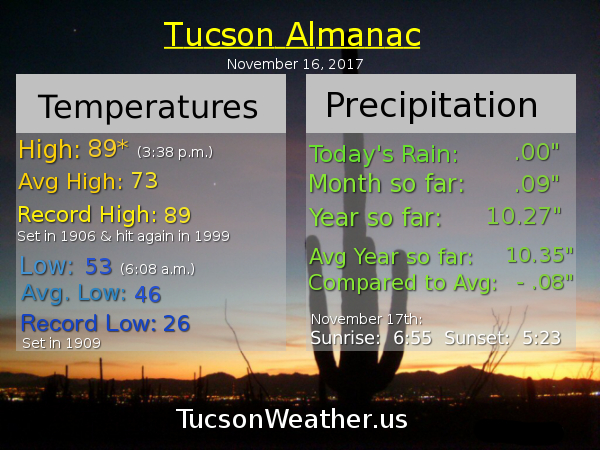
Almanac for Thursday, November 16, 2017
Forecast for Thursday, November 16, 2017
High pressure still in control with near record highs again today. If the forecast come exactly true we will miss the record of 89 set in 1909 and hit again in 1999 by one degree. Then strong storms missing us to our north will cool us off by about ten degrees by Saturday and Sunday morning’s low of 48 will be the first reading in the 40s since May 10th. We’ll warm back up again by Thanksgiving with highs back in the mid 80s! Sorry TEP. I don’t need heat or AC so I’ll keep my money if that’s OK with you.
Mostly sunny today with a high near 88ish.
Mostly clear tonight for the Leonid Meteor Shower and a low in the low 50s.
Mostly sunny Friday 84ish. Upper 70s Saturday and Sunday. Near 80 Monday. Low 80s Tuesday. Mid 80s Wednesday.
Almanac for Wednesday, November 15, 2017

Forecast for Wednesday, November 15, 2017
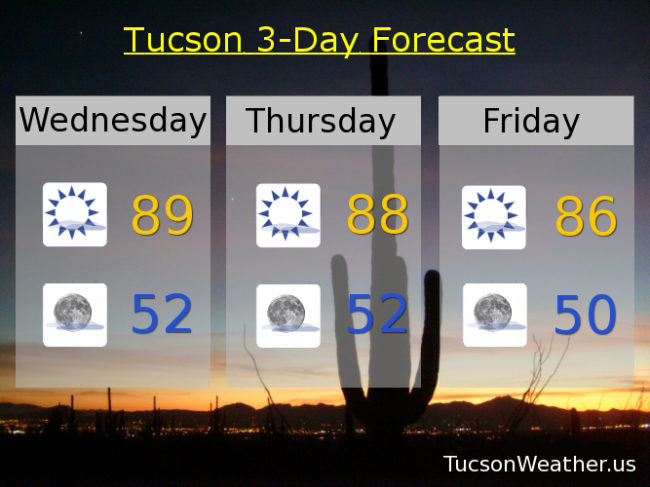
We continue to remain under pressure. High pressure centered over NW Mexico is large and in charge over southern Arizona causing our run of near record highs. Yesterday we hit 89 which was 1 short of the record and also the highest high in the United States. Today we do it again. If the forecast high of 89 is realized we will tie the record last hit last year. Sigh. There is some relief in sight. Strong storms affecting the Pacific Northwest will bring us a few degrees of cooling by this weekend, but we will remain well above the seasonal averages. Our average high and low for this time of year are 74 and 46 respectively. High clouds still in the forecast for possible sunrise and sunset enhancement so keep those cameras and smart phones handy!
Mostly sunny today with a high near 89.
Mostly clear tonight with a low near 52.
Upper 80s tomorrow. Mid 80s Friday. Near 80 Saturday. Low 80s Sunday, Monday and Tuesday.