Monthly Archives: February 2018

Forecast for Sunday, February 18, 2018

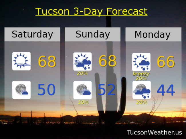
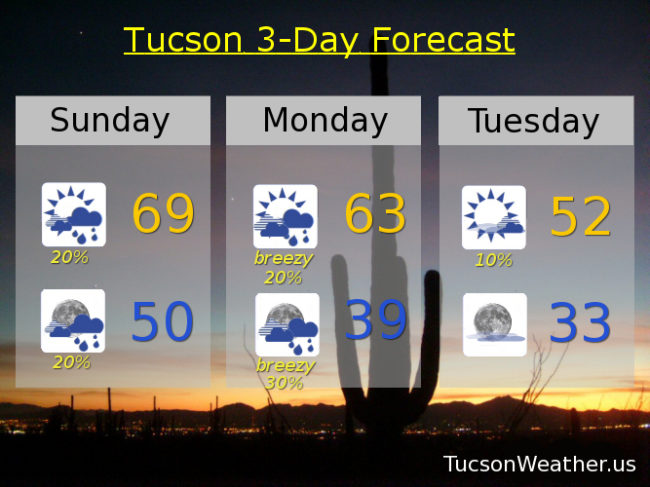
All of a sudden we are in a somewhat active weather pattern! A couple of storms are fixin’ to impact southern Arizona. The first one today is weak, but we have a lot of moisture still in place from last weeks rain. Call it a chance for scattered showers today and tonight with a high in the upper 60s and a low near 50ish.

Our second storm drops down from the north bringing gusty winds and cooler air. Snow levels should drop to near 4,000 feet before we are done, but most of the valley rain and mountain snow will fall before that happens. Still, we could see 1-4 inches of snow in the Catalinas above 5,000 feet. SSW winds 15-25 mph gusting over 35 and a high on Monday in the low 60s. Scattered showers and continued breezy Monday night with a low in the upper 30s.

Slight chance for a lingering shower or two Tuesday morning otherwise becoming mostly sunny and cool with a high in the low 50s.

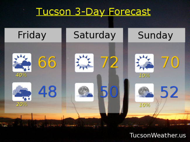
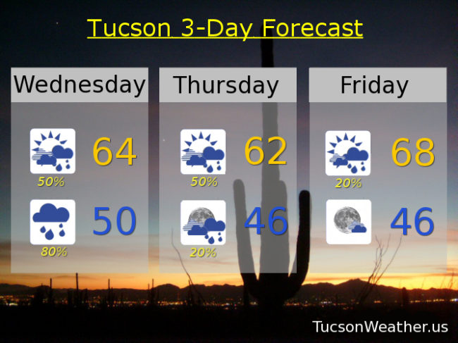
Sunny Wednesday after a near freezing start near 60. Mid 60s Thursday. Low 60s Friday. Mid 60s Saturday.

Forecast for Saturday, February 17, 2018

Add another .25″ to this months rain total yesterday and we now stand .28″ above average for the year! Areas of fog this morning (although it has lifted here in Oro Valley) for a DENSE FOG ADVISORY in effect until 9 a.m. so be advised, there may be some dense fog. The Sun returns today with some high cloudiness for possible sunset enhancement. High this afternoon near 68ish.

Partly cloudy tonight as another system approacheth. Low near 50.

Mostly cloudy tomorrow with a chance for showers and a high in the upper 60s.

Breezy (windy?) Monday with south winds 15-25 mph by afternoon gusting over 30. Chance for showers too with a high in the mid 60s. Slight chance for lingering showers Tuesday with a high near 60, or cooler. We could be down near freezing Wednesday morning. Stay tuned!

Mostly sunny Wednesday mid 60s. Upper 60s Thursday and Friday.

Forecast for Friday, February 16, 2018

It’s FRIIIDAAAY!

Wow, wow, wow, just wow! 1.01″ of rain yesterday at the airport is a new record for February 15th. All of a sudden we are .06″ above average rainfall for the year at 1.47″ 1.45″ of that came in the last two days! I grew up in Oregon (I may have mentioned that). A full day of light to moderate rain and drizzle plus this morning’s fog is making me homesick! I’ve lived here 12 1/2 years and I love it. It’s just nice when Oregon comes to visit me. It doesn’t happen that often.

The hits keep coming. Another disturbance is headed for southern Arizona from the south and that should give us a chance for scattered showers today. The best chance will be to our east but we should get in on some of the action. Nice and cool with a high near 66ish.

Slight chance for showers before midnight tonight and patchy fog tonight into tomorrow morning with a low in the upper 40s.

Patchy fog tomorrow morning then mostly sunny with some high clouds for possible sunset enhancement and a high in the low 70s.

Another system headed our way for a slight chance for showers Sunday near 70. Slight chance for showers Monday upper 60s.

Sunshine returns Tuesday mid 60s. Upper 60s Wednesday. Near 70 Thursday.

The National Weather service is watching another storm possibly bringing us more rain next weekend. We’ll keep you posted as always as we go. Stay tuned!

Forecast for Thursday, February 15, 2018

That worked out well! It has been a steady rain since last night! Almost half an inch of rain fell at the airport by midnight last night and we’ve added nearly another half inch of rain since then and it’s still coming down! We need it. An added bonus for this Oregon boy. I always love it when the weather from the Great Pacific Northwest comes for a visit!

Rain becoming showers by this afternoon and cool with a high near 58.

Mostly cloudy tonight with a few showers and a low in the upper 40s.

Mostly cloudy tomorrow with isolated showers possible and a high in the upper 60s.

Mostly sunny Saturday and Sunday low 70s.

A slight chance for showers Monday and breezy with a high in the upper 60s.

Mostly sunny Tuesday and Wednesday mid 60s.

Forecast for Wednesday, February 14, 2018

“Ohhh, I hear laughter in the rain, walking hand and hand with the one I love. Ohhh how I love a rainy day and the happy way I feel inside…” Happy Valentine’s Day! And what is Valentine’s Day without a little Neil Sedaka?! (hey, don’t judge 🙂 ) Our upper level low is off the southern California coast pulling moisture to the north into Arizona. A disturbance in the moisture fetch (fetching, isn’t it?) should trigger shower activity by this afternoon. Rain showers continue and even increase as we get into this evening and the overnight hours. Rain chances continue tomorrow. The rain starts to wane tomorrow night and Friday with sunshine returning for the weekend. Valley locations still looking at anywhere from a quarter inch to an inch of rain before it is all said and done, at the end of the day, and other trite phrases. Lower amounts more likely as you head west of Tucson. Higher amounts more likely south and east. We need the rain. Pray it’s on the high side!

Cloudy today with scattered showers by this afternoon and a high in the mid 60s.

Showers tonight with a low near 50.

Cloudy tomorrow with scattered showers tomorrow and a high in the low 60s.

Lingering showers possible Friday otherwise becoming partly cloudy with a high in the upper 60s.

Mostly sunny Saturday and Sunday with highs in the low 70s. Upper 60s Monday. Mid 60s Tuesday.