Monthly Archives: July 2018

Forecast for Saturday, July 21, 2018

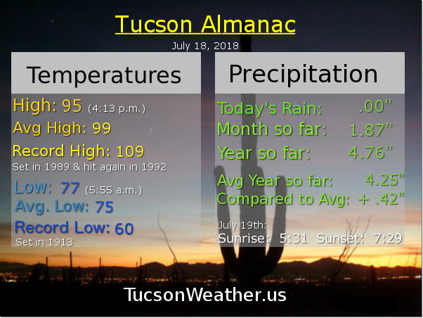
So nice out on the deck this morning! A cool breeze after the overnight rain. It looks like the NW side was the big winner once again. Catalina State Park picked up 1.65″ inches of rain! Oro Valley anywhere from a quarter inch to three-quarters. The east side got in on the action too with up to a half inch of rain. The airport picked up just .02″ which isn’t zero at least. Yesterday afternoon got crazy in Corona de Tucson with a severe storm that dumped 1″ hail and a bunch of rain. Thanx to Tina Wilson for sharing dramatic video on the FB page!

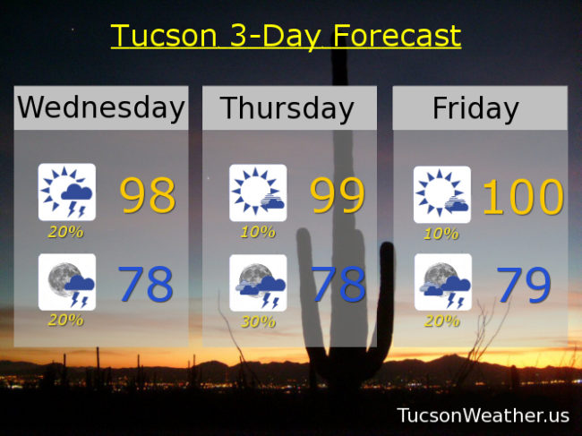
Just a slight chance for rain this afternoon and evening as we look to Monday, Tuesday and Wednesday for some big time heat. The National Weather Service has issued an EXCESSIVE HEAT WARNING for Monday and Tuesday, so be warned, the heat will be excessive! It will probably be expanded into Wednesday, so there’s that. High pressure will move away as next week wears on and we’ll see the return of Monsoon 2018. Until then, gird your loins!

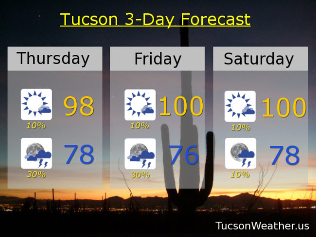
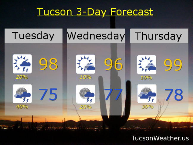
Becoming mostly sunny today with just a 10% chance for showers or a storm and a high in the upper 90s.

A 10% chance tonight with partly cloudy skies and a low in the upper 70s.

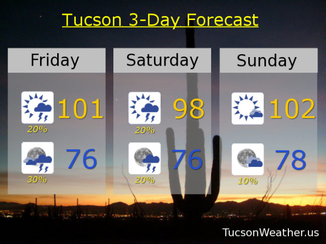
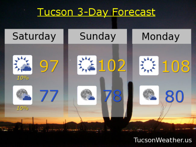
Mostly sunny tomorrow 102ish. Sunny Monday 108. 110 Tuesday! 108 Wednesday. 10% chance Thursday 102. 20% Friday 99.

Forecast for Friday, July 20, 2018

It’s Friiidaaay!!!

OK. I give up trying to predict whether the weather will bring us storms. Not really though, because here we are again. A disturbance in the force combined with a lot of moisture SHOULD give us scattered storms this afternoon and especially this evening. Time will tell. Hot today with a high near 101. Tonight’s low in the mid 70s.

Storm chances lingering into tomorrow with a 20% chance and a high in the upper 90s.

Mostly sunny and hot Sunday with a high near 102ish. Slight chance of evening storms and a low in the upper 70s.

Then. It’s the big hurt. High pressure basically trying to kill us as we start next week. EXCESSIVE HEAT WARNING Monday and Tuesday with highs of 108 and 110 respectively. The EXCESSIVE HEAT WARNING will likely be extended into Wednesday with a high of 108. Yikes! “Cooling” off Thursday to 102. We better get some good rain today and tomorrow, because the rest of the forecast is brutal! Stay tuned.

Forecast for Thursday, July 18, 2018

It’s Friday Eve. Makes the weekend seem closer!

Heating up as we go too. Interesting day and hopefully not too frustrating. Tons of moisture in place with a dewpoint of 70 this morning. As we heat up to the upper 90s this afternoon it will likely feel more like the low 100s thanx to that humidity. So. Will we get sweet relief from scattered storms? Maybe. Drier air above our heads will inhibit storm development some. Storms forming on the mountains no problem, but if storm anvil’s precede the storms themselves we may cut off needed lift to keep storms going. Lots of energy in the atmosphere though, so if we do manage storms, some may be on the strong to severe side! So many possibilities on how this may play out. We’ll go with a slight chance for storms this afternoon and scattered storms this evening with a muggy day in between. Today’s high near 98 feeling like 102.

Breezy tonight with a 30% chance for storms and a low in the upper 70s. ESE winds gusting to around 25 mph.

Isolated storms tomorrow with scattered activity tomorrow evening. High near 100. 10% chance for storms Saturday near 100ish. Mostly sunny Sunday 102. 108 Monday and Tuesday! Yikes! 10% chance Wednesday only 104.

Forecast for Wednesday, July 18, 2018

Monsoon 2018 is off to a terrific start for most of us, although there are some exceptions. A downturn is in our forecast, but not a complete shutdown. Isolated storms possible today and this evening with most of the activity in the mountains, but perhaps one near you too. Today’s high in the upper 90s with a low tomorrow morning in the upper 70s. Still very pleasant on the deck for morning coffee!

Just a 10% chance for afternoon storms tomorrow but that goes up to 30% by evening. High near 99. (99, I’ve been waiting so long. 99, where did we go wrong? Oh 99…. I love you.)

10% chance Friday near 100ish. 10% Saturday 101. Sunny Sunday 103. 106 Monday! 10% Tuesday 106. Moisture coming back mid next week. Stay tuned!

Forecast for Tuesday, July 17, 2018

Showers and storms yesterday evening with Oro Valley once again being the big winner. Storms were moving fast enough that even the heavy rain in the NW part of town was relatively brief. The airport picked up a tenth of an inch, so the Monsoon totals continue to increase almost daily. However. We are fixin’ to apply the breaks. Drier air moving in from the east will limit our storm chances today, although we will end up on the edge of the dry air, so maybe we’ll get storms after all. (how’s that for hedging my bets?) It will be close with the better chances to our west. Today’s high in the upper 90s. A better chance for storms tonight with SW breezes 10-20 mph and gusty and a low in the mid 70s.

Drier tomorrow with just a 10% chance for rain and a high in the mid 90s. 10% chance Thursday with a high in the upper 90s. 10% Friday near 101ish. 20% Saturday 101. Zero% Sunday and Monday with highs near 103 and 105 respectively. Enjoy.