Monthly Archives: August 2018

Forecast for Sunday, August 26, 2018

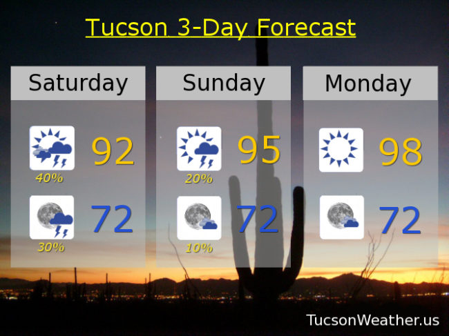
It was a beautiful Saturday! High of only 92. Lots of sunshine. But. The storm chances never became reality, so there’s that. One last chance for Monsoon 2018 to show off before she takes a break. Moisture in place today, but a westerly flow will take over and dry us out starting tonight. Monsoon 2018 may return to us by next weekend if we play our cards right. One cool thing about drier air is cooler mornings! Look at those lows near 70. Pretty perfect.

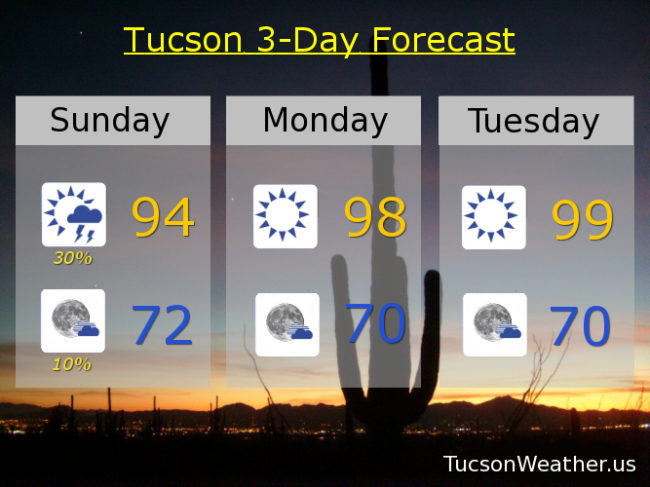
Mostly sunny today with a 30% chance for scattered storms this afternoon and a high in the mid 90s. 10% chance for storms this evening then partly cloudy with a low in the low 70s.

Sunny tomorrow, Tuesday and Wednesday upper 90s. Near 100ish Thursday. 101 Friday. 10% Saturday 100. Enjoy!

Forecast for Saturday, August 25, 2018

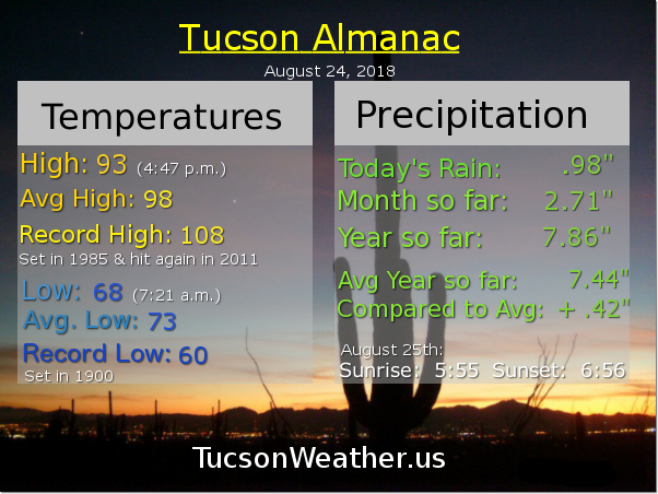
70 degrees and amazing on the deck this morning! That first cup of coffee even more satisfying after an amazing light show last night. Most of the Metro getting much deserved and needed rain with the airport picking up nearly an inch of rain (.98″). A big thanx to all who washed their car and left the patio furniture out yesterday! Moisture hanging around for one more day before we start to dry out. Scattered storms possible this afternoon and evening with locally heavy rain possible as one more disturbance moves our way out of Mexico (thank you Mexico!) Low 90s today and low 70s tonight. Viva Monsoon 2018!

Drier tomorrow but still a chance for an isolated storm or three, hopefully near you, with a high in the mid 90s. A more westerly flow will push out our moisture and bring sunshine and warmer temperatures next week. Upper 90s Monday and Tuesday. 100ish Wednesday and Thursday. 101 Friday.

Forecast for Friday, August 24, 2018

It’s Friiidaaay!!!

A FLASH FLOOD WATCH is in effect today from 11:00 this morning until Midnight tonight. So. Much. Moisture. Plus an inverted trough AND another upper low heading our way all adding up to what should be numerous storms today. Some storms will be capable of dropping 1-2 inches of rain (or more) in a short amount of time. We’ll see. We make fun of the jinx that often happens when the Weather Service issues a Flash Flood Watch. Yesterday was off to a promising start and then storms evaporated in the Metro as soon as the watch was issued! Still, flooding occurred in Nogales, near Sierra Vista, Douglas and more, so they weren’t wrong. Will Tucson see flooding rains today/tonight? It looks like a distinct possibility, so just remember to enjoy Monsoon 2018 responsibly. Don’t drive through running water and you should be good! I know you know that, but it’s worth mentioning because we at Tucson Weather care about you! ❤️ Viva Monsoon 2018!

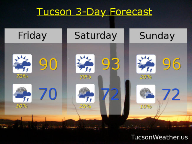
70% chance for storms today, some with heavy rainfall, and a high of only 90! 70 by tomorrow morning with a 50% chance for storms tonight. Again some with heavy rain possible.

Moisture and instability will be with us into tomorrow so a 30% chance for storms and a high near 93.

We start to dry out Sunday as we will be in a more westerly flow. A 20% chance for storms, but a better chance to our east. Sunday’s high in the mid 90s.

Drying out more Monday with a 10% chance upper 90s. Mostly sunny Tuesday and Wednesday near 100ish. Sunny Thursday 101.
Forecast for Thursday, August 23, 2018

Why did the trees cross the road? Microburst. That’s what happened around Old Father and Thornydale yesterday afternoon. Monsoon 2018 was rockin’ it in Marana and Oro Valley with 1 to 3 inches of rain and even some hail. Not everyone got soaked though. It rained at my apartment in southern OV but no where near an inch. The airport picked up .09″. I hope there was rain where you live. Viva Monsoon 2018! Maybe she does love us after all.

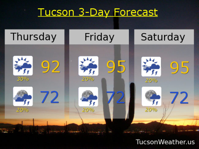
Let’s try it again this afternoon/evening! Lots of moisture still with us. If we can manage enough sunshine this morning we should be off and running this afternoon. Of course not everyone will get storms, but those that do could receive locally heavy rainfall. Low 90s this afternoon and low 70s by tomorrow morning.

Scattered storms continue through the weekend with drying expected next week. 20%/20% tomorrow and Saturday mid 90s. 20%/20% Sunday upper 90s. 10%/10% Monday upper 90s. 10% Tuesday 100ish. Sunny 100 Wednesday.

Forecast for Wednesday, August 22, 2018

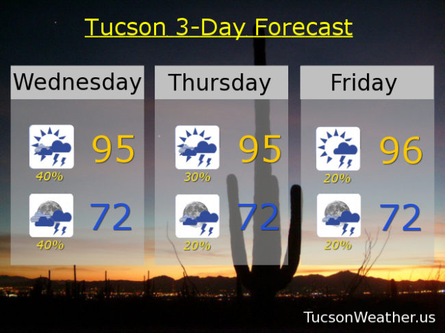
Another disappointing Monsoon 2018 afternoon yesterday as morning showers and clouds put the kibosh on afternoon/evening storms. Today’s the day! (unless it isn’t) Rich moisture and lots of morning Sun should (should) lead to afternoon storms with locally heavy rainfall possible. Hopefully our 40% chance becomes reality near you!

30% chance for storms tomorrow with a high in the mid 90s. 20% Friday mid 90s. 20% Saturday and Sunday upper 90s. 10% Monday upper 90s. 10% Tuesday 100ish.