Monthly Archives: October 2018

Forecast for Sunday, October 21, 2018

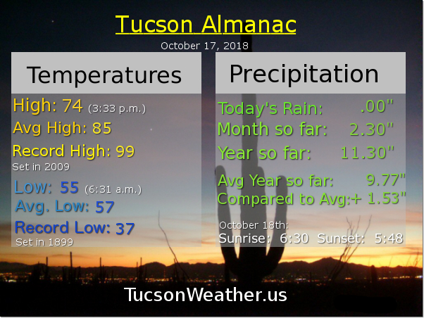
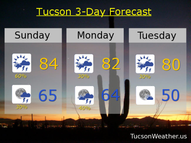
Yesterdays forecast came to pass. 87 and breezy. 3 degrees above average. Today’s average high is 83 and we’ll be very close near 84. The breezes continue out of the ESE 10-20 mph and gusting higher, but not as bad as yesterday. An upper level low is located over the central California coast with disturbances in the force rotating around it. One of those now located in SE CA is increasing the moisture and instability from Tucson west. We should see an increase in shower and thunderstorm activity as we go through the day. Scattered storms continue tonight with a low in the mid 60s.

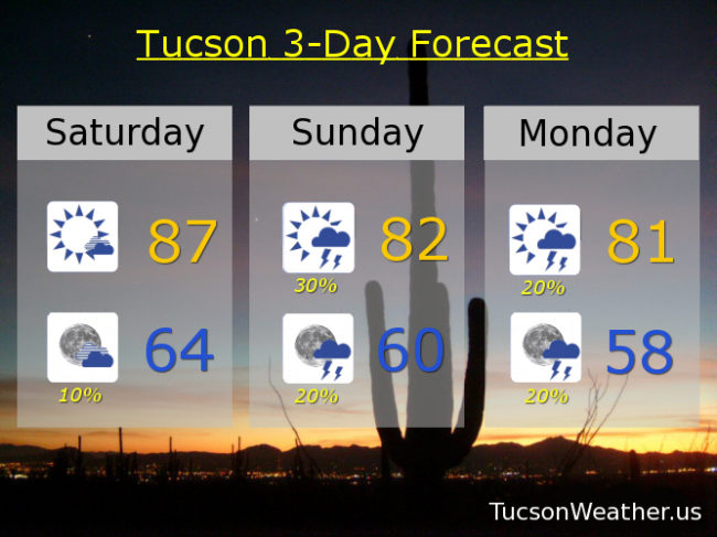
Our low continues to weaken and move our way giving as a chance for showers and storms through Tuesday. Winds will lighten up (Lighten up Frances! (Bill Murray in “Stripes”)) as we go. 30%/40% tomorrow/tomorrow night low 80s. 30% Tuesday near 80ish.

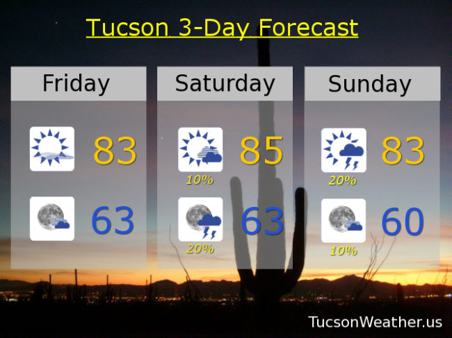
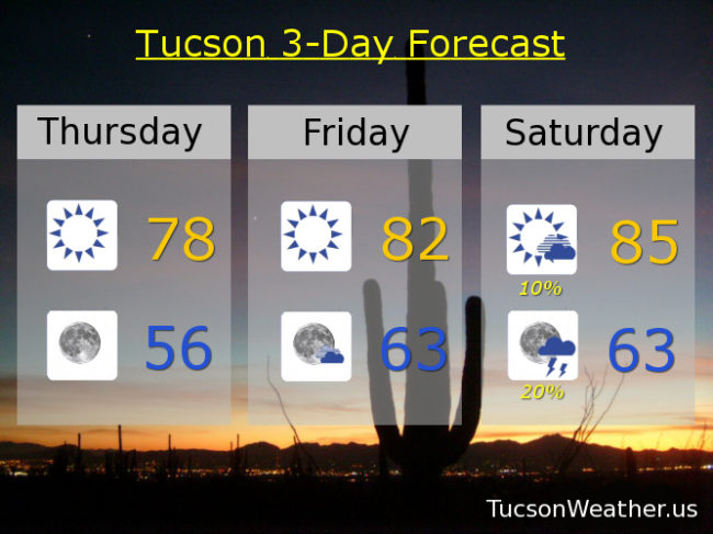
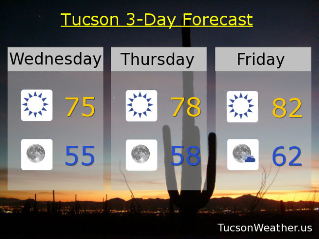
Trough gets out of here by Tuesday night leaving us with a drier NW flow. Temperatures right around average or a couple three degrees above as we go through the rest of the week. Sunny Wednesday 80. Low 80s Thursday and Friday. Mid 80s Saturday. Enjoy!

Forecast for Saturday, October 20, 2018

Welcome to the weekend! We haven’t seen this all October, but today will actually be above average! And while it’s true to a large extent that life is what you make it, as far as the high temperature is concerned we will end up 3 degrees above average for October 20th if the forecast comes exactly true. Part of the reason it’ll be so warm is the wind out of the ESE 15-25 mph gusting to near 40! Not considered pleasant by most. As the east winds run downhill the air compresses and warms, so… Also we are starting out relatively warm this morning. Again you can blame that on the wind (or give it credit. Either works). Breezy still tonight with ESE winds 15-25 mph gusting to near 35 with a 10% chance for a storm and a low in the mid 60s.

The main weather player through Tuesday is a low currently located along the California coast. That is kicking up our wind which is also importing more moisture. As disturbances in the force rotate around the low and through the area we should see some showers and storms. The low clears out by Tuesday night.

30% chance for storms tomorrow and still breezy with ESE winds 15-25 mph gusting over 30 and a high in the low 80s. 20% Monday low 80s. 20% Tuesday near 80ish. Sunny Wednesday and Thursday 80. Low 80s Friday. Enjoy!

Forecast for Friday, October 19, 2018

It’s Friiidaaay!!!

Pretty nice yesterday especially after the breezes calmed down. Today will be stellar! And not just because it’s Friiidaaay!!! Our closest star (Sol) will be obstructed only be a few high clouds today and the east southeast breezes will only be 5-15 or so. Today’s high pretty close to the average for this time of year of 84. All is well!

Well. A storm is brewing (forming really, but brewing sounds more dramatic! It’s the TV training) near southern California and the SE winds will be increasing and bringing more moisture with it. As the storm approacheth this weekend we’ll see more instability to help form some storms, hopefully near you! The winds will be kickin’ up though, so hang on to your hats, put rocks in your pocket, and perhaps we should issue a skirt alert. Everything moves east by Tuesday night drying us out and clearing us up (or drying us up and clearing us out? Either way I guess). Here are how the numbers look:

Mostly sunny tomorrow and breezy with ESE winds 15-25 mph gusting over 30. A 10% chance for a storm or two, hopefully near you, and a high in the mid 80s. Breezy tomorrow night with a 20% chance for storms with a low in the low 60s. 20% Sunday with ESE winds gusting over 25 and a high in the low 80s. 20% Monday low 80s. 10% Tuesday near 80ish. Sunny Wednesday 80. Upper 70s Thursday. Enjoy!

Forecast for Thursday, October 18, 2018

Happy Friday Eve! It makes the weekend seem closer! (trust me. It’s true)

Warming up! But still below average for this time of year. A bit of an east breeze persists as well. Sunny today upper 70s. That is about as pleasant as it gets. Clear skies tonight mid 50s. Sunshine and low 80s tomorrow.

Then. An upper level low approacheth. Actually, it is forecast to form over southern California out of nothing! The result? An increase in moisture and instability which should lead to a few showers and maybe even a thunderstorm or two. 10% Saturday mid 80s. 20% Sunday low 80s.

Then it’s back to the sunshine. low 80s Monday and Tuesday. Near 80 Wednesday. Enjoy!

Forecast for Wednesday, October 17, 2018

It’s a good old fashioned warming trend (as opposed to an Old Fashioned Love Song)! Mid 70s today with sunshine. I love the 70s. Three Dog Night. The Eagles. Linda Ronstadt. The Bee Gees. All good stuff. The 70s continue tomorrow after starting in the mid 50s. Tomorrow’s high near 78ish.

Then the 80s return! Madonna. Tears for Fears. Whitney Houston. Duran Duran. Low 80s Friday ahead of our next system. We’ll keep the 80s around Saturday with a 10% chance for showers and high in the mid 80s. Breezy too. Low 80s Sunday with a 30% chance for showers. 10% Monday low 80s. Sunny near 80 Tuesday. Enjoy! And crank it up!!!