Monthly Archives: December 2019

Forecast for Saturday, December 14, 2019

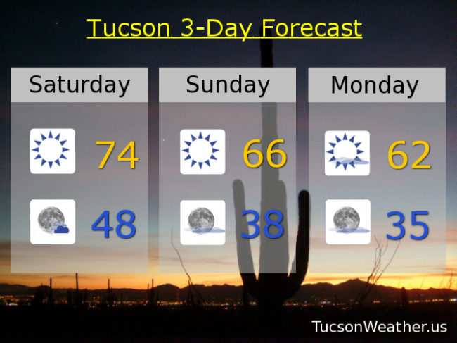
A beautiful 75 degrees yesterday and we do it again today with tons o’ Sun! Don’t get used to it. A cool down is on the way. It’s cool to be cool. (so I’ve heard) A storm missing us to the north will usher in a bit of a chill as it exits stage east by tomorrow. Could see some freezing temperatures in the metro near the washes and other colder prone areas Tuesday morning. Yeppers. Serving up some chilly! (mmm chili) A few high clouds for possible sunrise and sunset enhancement as well. A storm late in the week will miss us to the north keeping us from warming up too much. No rain or mountain snow expected. Let’s detail the details…

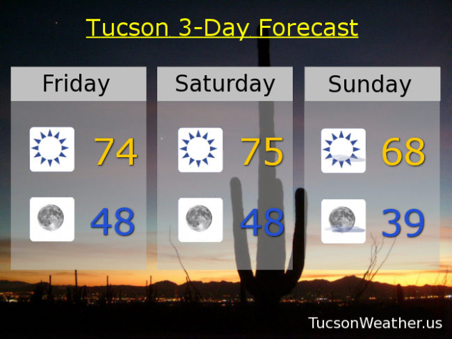
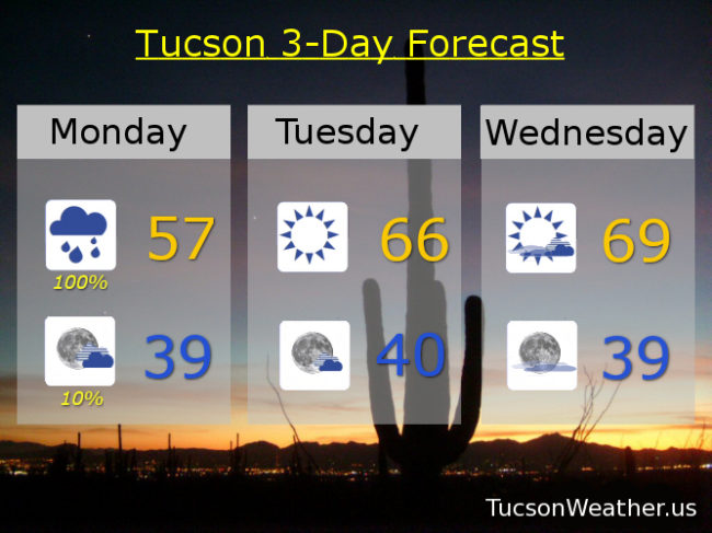
Sunny mid 70s today. Partly cloudy tonight upper 40s.

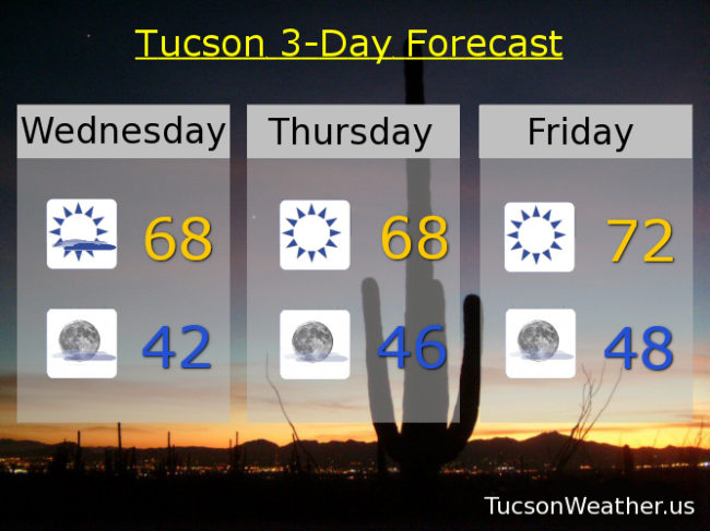
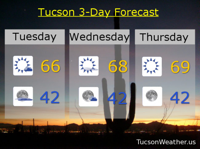
Cooler tomorrow mid 60s. Upper 30s tomorrow night. Mostly sunny low 60s Monday. Mid 30s (officially) Tuesday morning. Low 60s Tuesday and Wednesday. Mid 60s Thursday. Upper 60s Friday. Enjoy!

Forecast for Friday, December 13, 2019

It’s Friiidaaay!!! the 13th. Friday the 13th. No worries. Remember, Monday the 13th is MUCH worser! At least we don’t have giant spiders wondering around at night like in Minecraft! That would be terrifying. Don’t even get me started on Creepers, but I digress. Back to the Tucson Weather…

Nice warm up into the weekend before we cool off next week. Let’s take a look, shall we? We shall.

Sunny today and tomorrow with highs in the mid 70s! Lows in the upper 40s. Mostly sunny Sunday upper 60s.

A storm to our north and very cold air spilling into the Plains will filter colder air into Arizona. East winds kicking up a bit next week as well. Chilly (mmm chili) in the mornings and cool days. Another system headed our way late in the week.

Sunny Monday low 60s. Mid to upper 30s Tuesday morning. Sunny Tuesday low 60s. Mostly cloudy low 60s Wednesday. Mostly cloudy mid 60s Thursday. Will we see rain and mountain snow Thursday into next weekend? Maybe, but right now the National Weather Service is taking a wait and see how things develop as we get closer attitude. Stay tuned!

Forecast for Wednesday, December 11, 2019

Mike Mike Mike Mike Mike. What day is it Mike? Only 13 shopping days until Christmas! While you are hustling and bustling, the weather is chill. Not chilly (mmm chilli), but rather relaxed. A bit warmer as we head into the weekend and then some breezes along with a cool down next week. A few high clouds from time to time for possible sunrise and sunset enhancement. Here are the somewhat boring particulars…

Mostly cloudy this morning becoming mostly sunny this afternoon with gradual clearing and a high in the upper 60s.

Mostly clear tonight with a low (OK, kinda chilly) in the low 40s.

Sunny tomorrow upper 60s. Low 70s Friday. Mid 70s Saturday! Mostly sunny Sunday upper 60s. Sunny low 60s Monday. Mostly sunny mid 60s Tuesday. Enjoy!

Forecast for Tuesday, December 10, 2019

It’s Twofer Tuesday! Pretty much on every Classic Rock Station in America. Speaking of rock (and I think we were) Some pretty rockin’ storms shaking things up yesterday morning! The definition of rude awakening for some I suppose. The airport picked up a half inch of rain. We are now 2:02″ above average for the year! After some fog this morning we dry out and warm up for the next few days. The weekend looks amazing! A storm missing us to the north will cool us off early next week, but we will stay dry. Now the particulars…

A DENSE FOG ADVISORY until 9:00 this morning. Be advised. There will be some patchy dense fog. Otherwise sunny today with a high in the mid 60s.

Increasing clouds tonight with a low in the low 40s.

Decreasing clouds tomorrow becoming sunny with a high in the upper 60s. Sunny upper 60s Thursday. Low 70s Friday and Saturday. Mostly sunny upper 60s Sunday. Low 60s Monday. Enjoy!

Forecast for Monday, December 9, 2019

Rainy dayz and Mondays never get me down! I mean, yeah, it’s Monday, but rain makes it all better. An upper level low currently off the California coast is approachething. As it draws neigh showers and perhaps a few thunderstorms will continue off and on into the afternoon. Snow levels currently way up there above 8,000 feet. They will be coming down to about 7,000 this morning. So. The National Weather Service has issued a WINTER WEATHER ADVISORY above 7,000 feet until 5:00 this evening. Be advised. There will be Winter weather. 2 to 4 maybe more inches of snow for Summerhaven. The low should be to our south and east by tonight with rain on the wane.

Cloudy today with showers and maybe a few storms. Heavy rain possible at times for some. High in the upper 50s.

Clearing skies tonight with perhaps a lingering shower. Chilly (mmm chili) by morning with a low in the upper 30s.

Sunshine returns tomorrow with a high in the mid 60s. Partly sunny Wednesday upper 60s to near 70ish. Sunny Thursday upper 60s. Low 70s Friday and Saturday. Near 70 Sunday. Enjoy!